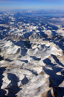
The Sierra Nevada is a mountain range in the Western United States, between the Central Valley of California and the Great Basin. The vast majority of the range lies in the state of California, although the Carson Range spur lies primarily in Nevada. The Sierra Nevada is part of the American Cordillera, a chain of mountain ranges that consists of an almost continuous sequence of such ranges that form the western "backbone" of North America, Central America, South America and Antarctica.

Loganville is a city in Walton and Gwinnett counties, Georgia, United States. The population was 10,458 at the 2010 census, up from 5,435 in 2000.

Monroe is a city in Walton County, Georgia, United States. It is located both 1 hour east of Atlanta via US-78 and GA-138 to I-20 westbound and east of Hartsfield Jackson Int'l Airport and is part of the exurban cities in the Atlanta metropolitan area. Monroe is also a city known for its accessibility to Conyers just 20 minutes away and Lawrenceville 35 minutes away. The population was 13,234 at the 2010 census and 13,858 at the 2016 census.

Loganville is a village in Sauk County, Wisconsin, United States. The population was 300 at the 2010 census. The village was named for Chauncey P. Logan who built the first house in 1853.

Mount Whitney is the tallest mountain in California, as well as the highest summit in the contiguous United States and the Sierra Nevada—with an elevation of 14,505 feet (4,421 m). It is in Central California, on the boundary between California's Inyo and Tulare counties, 84.6 miles (136.2 km) west-northwest of the lowest point in North America at Badwater Basin in Death Valley National Park at 282 ft (86 m) below sea level. The west slope of the mountain is in Sequoia National Park and the summit is the southern terminus of the John Muir Trail which runs 211.9 mi (341.0 km) from Happy Isles in Yosemite Valley. The east slope is in the Inyo National Forest in Inyo County.
Loganville is the name of several places in the United States of America:

The Inyo Mountains are a short mountain range east of the Sierra Nevada mountains in eastern California in the United States. The range separates the Owens Valley to the west from Saline Valley to the east, extending for approximately 70 mi (130 km) SSE from the southern end of the White Mountains, from which they are separated by Westgard Pass, to east of Owens Lake.

Mount Ritter is the highest mountain in Madera County, California, in the Western United States, at an elevation of 13,149 feet (4,008 m). It is also the highest and most prominent peak of its namesake, the Ritter Range, a subrange of the Sierra Nevada in the Ansel Adams Wilderness of the Inyo and Sierra National Forests. Mount Ritter is the 15th highest mountain peak in California with at least 500 meters of topographic prominence.

Junipero Serra Peak is the highest mountain in the Santa Lucia Mountains of California. It is also the highest peak in Monterey County. It is named after Franciscan Friar Junípero Serra, founder of the California Missions.

Mount Humphreys is a mountain peak in the Sierra Nevada on the Fresno-Inyo county line in the U.S. state of California. It is the 14th highest peak in California, and the highest peak in the Bishop area. The mountain was named by the California Geological Survey of 1873 for Andrew A. Humphreys, the chief engineer of the United States Army at the time.

Mount Darwin is a flat-topped mountain in the Sierra Nevada, on the border of between Fresno and Inyo counties in Kings Canyon National Park and the John Muir Wilderness of California.

Tamarack, formerly known as Camp Tamarack, is an unincorporated community in Calaveras County, California, in the United States. It was founded in the 1920s. A nearby weather station, located across the Alpine County line, has been the site of several United States meteorological records.

The Dinkey Lakes Wilderness is a federally designated wilderness area located 45 miles (72 km) northeast of Fresno, in the state of California, USA. It comprises 30,000 acres (12,141 ha) within the Sierra National Forest and was added to the National Wilderness Preservation System by the California Wilderness Act of 1984.

Mount Morgan is a mountain located in northwestern Inyo County, California, in the John Muir Wilderness of the Inyo National Forest.

The Pines is an unincorporated community in Butte County, California, United States.

Mono Hot Springs is a summer resort, campground, unincorporated community, and a group of hot springs in Fresno County, central California. It is located within the Sierra National Forest, 70 miles (110 km) northeast of Fresno via California State Route 168.

Andrade Corner is an unincorporated community in the Sierra Pelona Mountains, Los Angeles County, California.

Hill Point, also known as Hillpoint, is an unincorporated community in Sauk County, Wisconsin, United States. Hill Point is located on Wisconsin Highway 154 west of Loganville, in the town of Washington. Hill Point has a post office with ZIP code 53937. The community was formerly known as Tuckerville, after one William Tucker.

The “Boiling Point” was a section of road along Sierra Highway located in the Antelope Valley of the Mojave Desert, in northern Los Angeles County, California. It was so named because the steep grade there caused car radiators to overheat. The Boiling Point Garage, owned by Tex Miller and his wife, and the Boiling Point Café were located there.

Mount Gabb is in the central Sierra Nevada in the U.S. state of California. Mount Gabb is in the John Muir Wilderness of Sierra National Forest and is named after William More Gabb, a paleontologist and member of the Whitney Survey.


