
An earthquake – also called a quake, tremor, or temblor – is the shaking of the surface of Earth resulting from a sudden release of energy in the lithosphere that creates seismic waves. Earthquakes can range in intensity, from those that are so weak that they cannot be felt, to those violent enough to propel objects and people into the air, damage critical infrastructure, and wreak destruction across entire cities. The seismic activity of an area is the frequency, type, and size of earthquakes experienced over a particular time. The seismicity at a particular location in the Earth is the average rate of seismic energy release per unit volume. The word tremor is also used for non-earthquake seismic rumbling.
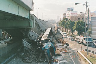
The Great Hanshin Earthquake occurred on January 17, 1995, at 05:46:53 JST in the southern part of Hyōgo Prefecture, Japan, including the region known as Hanshin. It measured 6.9 on the moment magnitude scale and had a maximum intensity of 7 on the JMA Seismic Intensity Scale. The tremors lasted for approximately 20 seconds. The focus of the earthquake was located 17 km beneath its epicenter, on the northern end of Awaji Island, 20 km away from the center of the city of Kobe.

A tuned mass damper (TMD), also known as a harmonic absorber or seismic damper, is a device mounted in structures to reduce mechanical vibrations, consisting of a mass mounted on one or more damped springs. Its oscillation frequency is tuned to be similar to the resonant frequency of the object it is mounted to, and reduces the object's maximum amplitude while weighing much less than it.

The Japan Meteorological Agency (JMA) Seismic Intensity Scale is a seismic intensity scale used in Japan to categorize the intensity of local ground shaking caused by earthquakes.

A response spectrum is a plot of the peak or steady-state response of a series of oscillators of varying natural frequency, that are forced into motion by the same base vibration or shock. The resulting plot can then be used to pick off the response of any linear system, given its natural frequency of oscillation. One such use is in assessing the peak response of buildings to earthquakes. The science of strong ground motion may use some values from the ground response spectrum for correlation with seismic damage.
Seismic analysis is a subset of structural analysis and is the calculation of the response of a building structure to earthquakes. It is part of the process of structural design, earthquake engineering or structural assessment and retrofit in regions where earthquakes are prevalent.
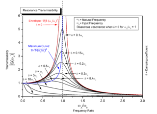
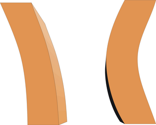
Mechanical resonance is the tendency of a mechanical system to respond at greater amplitude when the frequency of its oscillations matches the system's natural frequency of vibration closer than it does other frequencies. It may cause violent swaying motions and potentially catastrophic failure in improperly constructed structures including bridges, buildings and airplanes. This is a phenomenon known as resonance disaster.

The Indian subcontinent has a history of devastating earthquakes. The major reason for the high frequency and intensity of the earthquakes is that the Indian plate is driving into Asia at a rate of approximately 47 mm/year. Geographical statistics of India show that almost 58% of the land is vulnerable to earthquakes. A World Bank and United Nations report shows estimates that around 200 million city dwellers in India will be exposed to storms and earthquakes by 2050. The latest version of seismic zoning map of India given in the earthquake resistant design code of India [IS 1893 2002] assigns four levels of seismicity for India in terms of zone factors. In other words, the earthquake zoning map of India divides India into 4 seismic zones unlike its previous version, which consisted of five or six zones for the country. According to the present zoning map, Zone 5 expects the highest level of seismicity whereas Zone 2 is associated with the lowest level of seismicity.

Prediction of volcanic activity, or volcanic eruption forecasting, is an interdisciplinary monitoring and research effort to predict the time and severity of a volcano's eruption. Of particular importance is the prediction of hazardous eruptions that could lead to catastrophic loss of life, property, and disruption of human activities.
Seismic magnitude scales are used to describe the overall strength or "size" of an earthquake. These are distinguished from seismic intensity scales that categorize the intensity or severity of ground shaking (quaking) caused by an earthquake at a given location. Magnitudes are usually determined from measurements of an earthquake's seismic waves as recorded on a seismogram. Magnitude scales vary on what aspect of the seismic waves are measured and how they are measured. Different magnitude scales are necessary because of differences in earthquakes, the information available, and the purposes for which the magnitudes are used.
A slow earthquake is a discontinuous, earthquake-like event that releases energy over a period of hours to months, rather than the seconds to minutes characteristic of a typical earthquake. First detected using long term strain measurements, most slow earthquakes now appear to be accompanied by fluid flow and related tremor, which can be detected and approximately located using seismometer data filtered appropriately. That is, they are quiet compared to a regular earthquake, but not "silent" as described in the past.
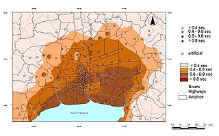
Seismic microzonation is defined as the process of subdividing a potential seismic or earthquake prone area into zones with respect to some geological and geophysical characteristics of the sites such as ground shaking, liquefaction susceptibility, landslide and rock fall hazard, earthquake-related flooding, so that seismic hazards at different locations within the area can correctly be identified. Microzonation provides the basis for site-specific risk analysis, which can assist in the mitigation of earthquake damage. In most general terms, seismic microzonation is the process of estimating the response of soil layers under earthquake excitations and thus the variation of earthquake characteristics on the ground surface.
Ground–structure interaction (SSI) consists of the interaction between soil (ground) and a structure built upon it. It is primarily an exchange of mutual stress, whereby the movement of the ground-structure system is influenced by both the type of ground and the type of structure. This is especially applicable to areas of seismic activity. Various combinations of soil and structure can either amplify or diminish movement and subsequent damage. A building on stiff ground rather than deformable ground will tend to suffer greater damage. A second interaction effect, tied to mechanical properties of soil, is the sinking of foundations, worsened by a seismic event. This phenomenon is called soil liquefaction.
The Richter scale, also called the Richter magnitude scale, Richter's magnitude scale, and the Gutenberg–Richter scale, is a measure of the strength of earthquakes, developed by Charles Francis Richter in collaboration with Beno Gutenberg, and presented in Richter's landmark 1935 paper, where he called it the "magnitude scale". This was later revised and renamed the local magnitude scale, denoted as ML or ML .
In geophysics, geology, civil engineering, and related disciplines, seismic noise is a generic name for a relatively persistent vibration of the ground, due to a multitude of causes, that is often a non-interpretable or unwanted component of signals recorded by seismometers.
Recent advances are improving the speed and accuracy of loss estimates immediately after earthquakes so that injured people may be rescued more efficiently. "Casualties" are defined as fatalities and injured people, which are due to damage to occupied buildings. After major and large earthquakes, rescue agencies and civil defense managers rapidly need quantitative estimates of the extent of the potential disaster, at a time when information from the affected area may not yet have reached the outside world. For the injured below the rubble every minute counts. To rapidly provide estimates of the extent of an earthquake disaster is much less of a problem in industrialized than in developing countries. This article focuses on how one can estimate earthquake losses in developing countries in real time.
The 1979 Imperial Valley earthquake occurred at 16:16 Pacific Daylight Time on 15 October just south of the Mexico–United States border. It affected Imperial Valley in Southern California and Mexicali Valley in northern Baja California. The earthquake had a relatively shallow hypocenter and caused property damage in the United States estimated at US$30 million. The irrigation systems in the Imperial Valley were badly affected, but no deaths occurred. It was the largest earthquake to occur in the contiguous United States since the 1971 San Fernando earthquake eight years earlier.

Earthquake environmental effects are the effects caused by an earthquake, including surface faulting, tsunamis, soil liquefactions, ground resonance, landslides and ground failure, either directly linked to the earthquake source or provoked by the ground shaking. These are common features produced both in the near and far fields, routinely recorded and surveyed in recent events, very often remembered in historical accounts and preserved in the stratigraphic record. Both surface deformation and faulting and shaking-related geological effects not only leave permanent imprints in the environment, but also dramatically affect human structures. Moreover, underwater fault ruptures and seismically-triggered landslides can generate tsunami waves.
Seismic risk in Malta is considered to be low with little historic damage noted and no known victims. The archipelago is however in a potentially significant seismic zone and the risk to the population is probably undervalued.
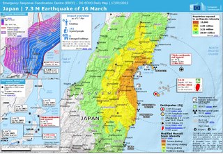
On March 16, 2022, at 23:36 JST, a strong earthquake struck off the coast of Fukushima, Japan. The earthquake had a magnitude of 7.4 according to the Japanese Meteorological Agency (JMA), while the United States Geological Survey (USGS) gave an estimate of 7.3. Immediately after the event a 30‑cm tsunami was reported. The event is known in Japanese as Fukushima-ken Oki Jishin. As a result of this natural disaster, three people died and 247 were injured.