Lost Wilson Mountain

Last updated
Lost Wilson Mountain
Lost Wilson Mountain.jpg
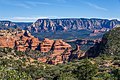
West aspect (from Bear Mountain)
Highest point
Elevation 6,762 ft (2,061 m) [1]
Prominence 342 ft (104 m) [1]
Parent peak Wilson Mountain (7,122 ft) [1]
Isolation 1.79 mi (2.88 km) [1]
Coordinates 34°55′44″N111°46′46″W / 34.9288998°N 111.7793138°W / 34.9288998; -111.7793138 [2]
Naming
Etymology Richard Wilson
Geography
USA Arizona relief location map.svg
Red triangle with thick white border.svg
Lost Wilson Mountain
Location in Arizona
Usa edcp relief location map.png
Red triangle with thick white border.svg
Lost Wilson Mountain
Lost Wilson Mountain (the United States)
CountryUnited States
State Arizona
County Yavapai
Protected area Red Rock-Secret Mountain Wilderness
Parent range Colorado Plateau [3]
Topo map USGS Wilson Mountain AZ
Geology
Rock age Permian
Rock type Basalt
Coconino Sandstone
Schnebly Hill Formation

Lost Wilson Mountain is a 6,762-foot-elevation (2,061-meter) summit in Yavapai County, Arizona, United States.

Contents

Description

Wilson Mountain is located four miles north of Sedona in the Red Rock-Secret Mountain Wilderness, on land managed by Coconino National Forest. It is the third-highest peak in the wilderness. [1] The summit lies within Yavapai County, whereas the eastern half of this landform is within Coconino County. [2] Precipitation runoff from this mountain drains into the Oak Creek watershed. Topographic relief is significant as the summit rises 1,760 feet (536 meters) above Sterling Canyon in 0.6 mile (1 km). The nearest higher neighbor is Wilson Mountain, 1.79 miles (2.88 km) to the southeast. [3] The mountain's toponym has been officially adopted by the United States Board on Geographic Names. [2]

Climate

According to the Köppen climate classification system, Lost Wilson Mountain is located in a temperate semi-arid climate zone. [4] Climbers can expect afternoon rain and lightning from the seasonal monsoon in late July and August.

See also

Related Research Articles

<span class="mw-page-title-main">Humphreys Peak</span> Highest mountain in Arizona

Humphreys Peak is the highest natural point and the second most prominent peak after Mount Graham in the U.S. state of Arizona, with an elevation of 12,633 feet (3,851 m) and is located within the Kachina Peaks Wilderness in the Coconino National Forest, about 11 miles (17.7 km) north of Flagstaff, Arizona. Humphreys Peak is the highest of a group of dormant volcanic peaks known as the San Francisco Peaks.

<span class="mw-page-title-main">Brahma Temple (Grand Canyon)</span> Landform in the Grand Canyon, Arizona

Brahma Temple is a 7,551-foot-elevation summit located in the Grand Canyon, in Coconino County of Arizona, US. It is situated six miles (9.7 km) north-northeast of the Yavapai Point overlook on the canyon's South Rim, and 4.5 miles south of the North Rim's Bright Angel Point. It towers 5,000 feet above Phantom Ranch in Bright Angel Canyon. Its nearest higher neighbor is Oza Butte, four miles to the north-northwest. Other neighbors include Zoroaster Temple one mile to the south, and Deva Temple, 1.5 miles to the north. Brahma Temple is named for Brahma, the Hindu creator of the universe. This name was applied by Clarence Dutton who began the tradition of naming geographical features in the Grand Canyon after mythological deities. This geographical feature's name was officially adopted in 1906 by the U.S. Board on Geographic Names.

<span class="mw-page-title-main">O'Neill Butte</span> Landform in the Grand Canyon, Arizona

O'Neill Butte is a 6,071-foot (1,850 m)-elevation summit located in the Grand Canyon, in Coconino County of northern Arizona, United States. It is situated 2.5 miles (4.0 km) east-northeast of Grand Canyon Village, one mile (1.6 km) northeast of Mather Point, and one mile immediately northwest of Yaki Point. Cedar Ridge connects O'Neill Butte with Yaki Point on the South Rim. Topographic relief is significant as O'Neill Butte rises 3,600 feet (1,100 m) above the Colorado River in two miles (3.2 km). Access to this prominence is via the South Kaibab Trail which traverses the east slope of the peak. According to the Köppen climate classification system, O'Neill Butte is located in a cold semi-arid climate zone.

<span class="mw-page-title-main">Mount Hilgard</span> Mountain in California, United States

Mount Hilgard is a 13,361-foot-elevation (4,072 meter) mountain summit located west of the crest of the Sierra Nevada mountain range in Fresno County of northern California, United States. It is situated in the John Muir Wilderness on land managed by Sierra National Forest, approximately eight miles east-southeast of Lake Thomas A Edison, and immediately above the west end of Lake Italy. The nearest higher neighbor is Mount Gabb, 1.75 miles (2.82 km) to the northeast, and Recess Peak is 2.2 miles (3.5 km) to the northwest. The John Muir Trail follows Bear Creek to the west of this remote peak, providing an approach. Mt. Hilgard ranks as the 82nd highest summit in California.

<span class="mw-page-title-main">Parker Peak (California)</span> Mountain in the American state of California

Parker Peak is a 12,861-foot-elevation (3,920-meter) mountain summit located in the Sierra Nevada mountain range, in Mono County of northern California, United States. It is situated in the Ansel Adams Wilderness, on land managed by Inyo National Forest. It is approximately 7.0 miles (11.3 km) northwest of the community of June Lake, 1.2 miles (1.9 km) east of Yosemite National Park's eastern boundary, and 1.0 mile (1.6 km) east of Koip Peak, the nearest higher neighbor. The mountain is visible from the June Lake Loop, and from the nearby June Mountain ski area. Topographic relief is significant as it rises over 5,700 feet above Grant Lake in four miles. The peak's name is derived from Parker Creek, which in turn was named after an early settler of Mono County. This geographical feature's name has been officially adopted by the U.S. Board on Geographic Names. The first ascent of the summit was made in 1914 by Norman Clyde.

<span class="mw-page-title-main">Cirque Peak (California)</span> Mountain summit in California

Cirque Peak is a 12,900-foot-elevation (3,900-meter) mountain summit located on the crest of the Sierra Nevada mountain range in California. It is situated on the common border of Tulare County with Inyo County, as well as the shared boundary of Golden Trout Wilderness and John Muir Wilderness, on land managed by Inyo National Forest. It is 14 miles (23 km) southwest of the community of Lone Pine, 7.7 miles (12.4 km) south-southeast of Mount Whitney, and 3.2 miles (5.1 km) south of Mount Langley, the nearest higher neighbor. Cirque Peak is the highest point of the Golden Trout Wilderness, and ranks as the 175th highest peak in California. Topographic relief is significant as it rises 1,800 feet above Cirque Lake in approximately one mile. The Pacific Crest Trail traverses the southwest slope of this mountain, providing an approach option. The mountain was apparently named in 1890 by Joseph Nisbet LeConte and companions who noted the remarkable cirque on the north aspect.

<span class="mw-page-title-main">Mount Bago</span> Mountain in the state of California

Mount Bago is an 11,870-foot-elevation (3,620-meter) mountain summit located west of the crest of the Sierra Nevada mountain range, in the southeast corner of Fresno County, in northern California. It is situated in Kings Canyon National Park, 14 miles (23 km) west of the community of Independence, 2.3 miles west of the Kearsarge Pinnacles, and 2.4 miles southwest of Mount Rixford. Topographic relief is significant as the south aspect rises 3,675 feet above Junction Meadow in one mile. The John Muir Trail passes to the northeast of this remote geographical feature. The first ascent of the summit was made July 11, 1896, by Joseph Nisbet LeConte and Wilson S. Gould.

<span class="mw-page-title-main">Mount Lamarck</span> Mountain in the state of California

Mount Lamarck is a 13,417-foot-elevation (4,090-meter) mountain summit located on the crest of the Sierra Nevada mountain range in northern California, United States. It is situated on the shared boundary of Kings Canyon National Park with John Muir Wilderness, and along the common border of Fresno County with Inyo County. It is 20 miles (32 km) southwest of the community of Bishop, and 1.9 miles (3.1 km) north of Mount Darwin. Subsidiary peak Mount Lamarck North (13,464 feet ranks as the 67th highest summit in California, and the sixth highest in the Evolution Region. Topographic relief is significant as the east aspect rises 4,290 feet above Lake Sabrina in three miles, and the west aspect rises 3,600 feet above Evolution Valley in three miles.

<span class="mw-page-title-main">Goodale Mountain</span> Mountain in the American state of California

Goodale Mountain is a 12,772-foot-elevation (3,893-meter) mountain summit located one mile east of the crest of the Sierra Nevada mountain range, in Inyo County of northern California. It is situated less than two miles southeast of Taboose Pass in the John Muir Wilderness, on land managed by Inyo National Forest. It is also 16.5 miles (26.6 km) northwest of the community of Independence, and one mile northeast of Striped Mountain, the nearest higher neighbor. Topographic relief is significant as the east aspect rises 7,200 feet above Owens Valley in 3.5 miles. It ranks as the 218th highest peak in California.

<span class="mw-page-title-main">Highland Peak (California)</span> Mountain in the American state of California

Highland Peak is a prominent 10,936-foot-elevation (3,333-meter) mountain summit located in the Sierra Nevada mountain range, in Alpine County of northern California, United States. It is situated 3.5 miles east of Ebbetts Pass in the Carson-Iceberg Wilderness, on land managed by Humboldt–Toiyabe National Forest. Although it ranks as the 680th-highest summit in California, it ranks 36th-highest of those with at least 500 meters of topographic prominence. Also, there is no higher peak than Highland Peak to the north within the Sierra Nevada. Highland Peak has a subsidiary South Peak, with one-half mile separation between summits. The Pacific Crest Trail traverses the western foot of this mountain, providing an approach option. Precipitation runoff from this mountain drains into tributaries of the East Fork Carson River.. Topographic relief is significant as the summit rises over 2,900 feet above Noble Canyon in 1.6 mile (2.6 km).

<span class="mw-page-title-main">Engineer Mountain</span> Mountain in Colorado, United States

Engineer Mountain is a 12,968-foot-elevation (3,953-meter) mountain summit located in San Juan County, Colorado, United States. It is part of the San Juan Mountains range which is a subset of the Rocky Mountains, and is west of the Continental Divide. Engineer Mountain is a prominent landmark set 1.5 mile immediately west of Coal Bank Pass, and is visible from multiple viewpoints along Highway 550, making it one of the most photographed mountains in the San Juans. It is situated 11 miles southwest of the community of Silverton, on land managed by San Juan National Forest. Topographic relief is significant as the southwest aspect rises 3,800 feet above Cascade Creek in approximately two miles. Neighbors include Snowdon Peak seven miles to the east, and Twilight Peak, five miles to the southeast.

<span class="mw-page-title-main">Pilot Knob (Fresno County, California)</span> Mountain in the state of California

Pilot Knob is a 12,245-foot-elevation (3,732 meter) mountain summit located in Fresno County in the Sierra Nevada mountain range in northern California, United States. It is situated at the intersection of Piute Canyon and French Canyon, in the John Muir Wilderness, on land managed by Sierra National Forest. It is set 2.5 miles (4.0 km) south of Merriam Peak and three miles north of the Matthes Glaciers. Pilot Knob is the 360th-highest peak in California, and topographic relief is significant as the west aspect rises 2,800 feet above Hutchinson Meadow in approximately one mile. This mountain was likely named by the USGS during the 1907–09 survey for the Mt. Goddard Quadrangle, and the toponym has been officially adopted by the U.S. Board on Geographic Names.

<span class="mw-page-title-main">Graveyard Peak</span> Mountain in the American state of California

Graveyard Peak is an 11,539-foot-elevation (3,517 meter) mountain summit located in the Sierra Nevada mountain range in Fresno County of northern California, United States. It is situated in the John Muir Wilderness, on land managed by Sierra National Forest. Graveyard Peak ranks as the 535th-highest summit in California, and topographic relief is significant as the south aspect rises over 2,300 feet above Devils Bathtub in approximately one mile. It is two miles southeast of Silver Peak, five miles north of Lake Thomas A Edison, and approximately 13 miles (21 km) south of the community of Mammoth Lakes. The peak is set on Silver Divide, so precipitation runoff from the north side of this mountain drains into Fish Creek which is a tributary of the San Joaquin River, and from the south slope to Lake Thomas A Edison. The peak is most easily reached out of Lake Thomas Edison.

<span class="mw-page-title-main">Rincon Peak</span> Mountain in Arizona, United States

Rincon Peak is an 8,482-foot-elevation (2,585-meter) mountain summit in Pima County, Arizona, United States.

<span class="mw-page-title-main">Capitol Butte</span> Summit in Arizona, United States

Capitol Butte is a 6,355-foot-elevation (1,937-meter) summit in Yavapai County, Arizona, United States.

<span class="mw-page-title-main">Wilson Mountain (Arizona)</span> Mountain in Arizona, United States

Wilson Mountain is a 7,122-foot-elevation (2,171-meter) summit in Coconino County, Arizona, United States.

<span class="mw-page-title-main">Bear Mountain (Loy Butte, Arizona)</span> Mountain in Arizona, United States

Bear Mountain is a 6,572-foot-elevation (2,003-meter) summit in Yavapai County, Arizona, United States.

<span class="mw-page-title-main">East Pocket Knob</span> Mountain in Arizona, United States

East Pocket Knob is a 7,196-foot-elevation (2,193-meter) summit in Coconino County, Arizona, United States.

<span class="mw-page-title-main">Josephine Peak</span> Mountain in California, United States

Josephine Peak is a 5,561-foot-elevation (1,695 meter) mountain summit located in the San Gabriel Mountains, in Los Angeles County, California, United States.

<span class="mw-page-title-main">Two Nuns</span> Summit in Arizona, United States

Two Nuns are 5,140-foot-elevation (1,567-meter) summits in Coconino County, Arizona, United States.

References

  1. 1 2 3 4 5 "Lost Wilson Mountain - 6,762' AZ". listsofjohn.com. Retrieved 2024-05-12.
  2. 1 2 3 "Lost Wilson Mountain". Geographic Names Information System . United States Geological Survey, United States Department of the Interior . Retrieved 2024-05-12.
  3. 1 2 "Lost Wilson Mountain, Arizona". Peakbagger.com. Retrieved 2024-05-12.
  4. Peel, M. C.; Finlayson, B. L.; McMahon, T. A. (2007). "Updated world map of the Köppen−Geiger climate classification". Hydrol. Earth Syst. Sci. 11. ISSN   1027-5606.