Lucien, Oklahoma | |
|---|---|
 Lucien, Oklahoma  Lucien, Oklahoma | |
| Coordinates: 36°16′29″N97°27′18″W / 36.27472°N 97.45500°W | |
| Country | United States |
| State | Oklahoma |
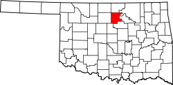
| County | Noble |
| Area | |
• Total | 0.55 sq mi (1.42 km2) |
| • Land | 0.55 sq mi (1.42 km2) |
| • Water | 0 sq mi (0.00 km2) |
| Elevation | 1,119 ft (341 m) |
| Population (2020) | |
• Total | 66 |
| • Density | 120.7/sq mi (46.61/km2) |
| Time zone | UTC-6 (Central (CST)) |
| • Summer (DST) | UTC-5 (CDT) |
| ZIP code | 73757 [3] |
| Area code | 580 |
| GNIS feature ID | 2629930 [2] |
Lucien is a census-designated place (CDP) and unincorporated community in Noble County, Oklahoma, United States. Its population was 88 as of the 2010 census. [4]