Lupton, Michigan

Last updated
Lupton, Michigan
Lupton, Michigan (CDP).jpg
Looking north along Main Street
Lupton (CDP), MI location.png
Location within Ogemaw County
USA Michigan location map.svg
Red pog.svg
Lupton
Location within the state of Michigan
Usa edcp location map.svg
Red pog.svg
Lupton
Location within the United States
Coordinates: 44°25′52″N84°01′33″W / 44.43111°N 84.02583°W / 44.43111; -84.02583 Coordinates: 44°25′52″N84°01′33″W / 44.43111°N 84.02583°W / 44.43111; -84.02583
CountryUnited States
State Michigan
County Ogemaw
Townships Cumming and Rose
Settled1880
Area
[1]
  Total3.26 sq mi (8.45 km2)
  Land3.23 sq mi (8.37 km2)
  Water0.03 sq mi (0.08 km2)
Elevation
922 ft (281 m)
Population
 (2020)
  Total318
  Density98.39/sq mi (37.99/km2)
Time zone UTC-5 (Eastern (EST))
  Summer (DST) UTC-4 (EDT)
ZIP code(s)
48635
Area code(s) 989
GNIS feature ID1620647 [2]

Lupton is an unincorporated community and census-designated place (CDP) in Ogemaw County in the U.S. state of Michigan. At the 2010 census, it had a population of 348. Lupton is located mostly within Rose Township with a small portion extending south into Cumming Township. [3]

Contents

History

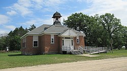
Rose Township District No. 5 School Rose Township Fractional District No 5 School.jpg
Rose Township District No. 5 School

Lupton was settled as early as 1880 by several Quaker families from Ohio, including that of Emmor Lupton. The community was first known as Lane Heights and given a post office under the name Lane on April 11, 1881. A depot on the Detroit, Bay City and Alpena Railroad was opened in January 1893. The post office was renamed Lupton in June 1893. [4] The post office name changed to Lupton on June 8, 1893. [5]

The Lupton Schoolhouse was constructed from 1903–1904 and served Lupton as the Rose Township District No. 5 School. The two-room schoolhouse remained in operation until 1963. The site was dedicated as a Michigan State Historic Site on April 20, 1995. [6]

The community of Lupton was listed as a newly-organized census-designated place for the 2010 census, meaning it now has officially defined boundaries and population statistics for the first time. [7]

The post office remained in operation until it was discontinued on November 5, 2011. Although the community contains no post office, the Lupton 48635 ZIP Code remains active is now served by the Rose City post office. [8] [9]

Geography

According to the U.S. Census Bureau, the community has an area of 3.26 square miles (8.44 km2), of which 3.23 square miles (8.37 km2) is land and 0.03 square miles (0.08 km2) (0.92%) is water. [3]

The Rifle River flows through Lupton, and the Rifle River State Recreation Area is just to the south and use the Lupton ZIP Code.

Demographics

Historical population
CensusPop.
2020 318
U.S. Decennial Census [10]

Related Research Articles

Berrien Township, Michigan Civil township in Michigan, United States

Berrien Township is a civil township of Berrien County in the U.S. state of Michigan. As of the 2010 census, the township population was 5,084.

Volinia Township, Michigan Civil township in Michigan, United States

Volinia Township is a civil township of Cass County in the U.S. state of Michigan. The population was 1,112 at the 2010 census. When the township was organized in 1833, it was at first named Volhynia, after the province in Poland. It is believed to have been given to honor General Tadeusz Kościuszko, the Polish patriot who helped the United States during the American Revolutionary War. The name was altered first to "Volenia" and then by 1901 or earlier to "Volinia".

Somerset Township, Michigan Civil township in Michigan, United States

Somerset Township is a civil township of Hillsdale County in the U.S. state of Michigan. The population was 4,623 at the 2010 census. The Grand River, Michigan's longest river, begins at natural springs within the township.

Maybee, Michigan Village in Michigan, United States

Maybee is a village in Monroe County in the U.S. state of Michigan. The population was 562 at the 2010 census. The village is located within Exeter Township. Maybee was established in 1873 and incorporated as a village in 1899.

Goodar Township, Michigan Civil township in Michigan, United States

Goodar Township is a civil township of Ogemaw County in the U.S. state of Michigan. As of the 2010 census, the township population was 493.

Gilford Township is a civil township of Tuscola County in the U.S. state of Michigan. The population was 741 at the 2010 Census.

River Rouge, Michigan City in Michigan, United States

River Rouge is a city in Wayne County in the U.S. state of Michigan. The population was 7,224 at the 2020 census.

Attica is an unincorporated community and census-designated place in Attica Township, Lapeer County, Michigan, United States. Its population was 994 as of the 2010 census. Attica has a post office with ZIP code 48412.

Arcadia is an unincorporated community and census-designated place in Arcadia Township, Manistee County, Michigan, United States. Its population was 291 as of the 2010 census. The community is located along M-22 and the Lake Michigan shore. Arcadia has a post office with ZIP code 49613.

Bay Port, Michigan Census-designated place & unincorporated community in Michigan, United States

Bay Port is an unincorporated community and census-designated place (CDP) in Huron County in the U.S. state of Michigan. The population was 477 at the 2010 census. As an unincorporated community, Bay Port has no legal autonomy of its own but does have its own post office with the 48720 ZIP Code.

Bay Shore, Michigan Census-designated place & unincorporated community in Michigan, United States

Bay Shore is an unincorporated community and census-designated place located on the boundary between Charlevoix and Emmet counties in the U.S. state of Michigan. As of the 2010 census it had a population of 754.

Brethren is an unincorporated community and census-designated place in Dickson Township, Manistee County, Michigan, United States. Its population was 410 as of the 2010 census. The community is located in the Manistee National Forest roughly 15 miles (24 km) east of Manistee. Brethren has a post office with ZIP code 49619.

Wellston is an unincorporated community and census-designated place in Norman Township, Manistee County, Michigan, United States. Its population was 246 as of the 2020 census. The community is in the Manistee National Forest just south of M-55, about 20 miles east of Manistee and about 25 miles west of Cadillac. Wellston has a post office with ZIP code 49689.

Cedar, Michigan Census-designated place & unincorporated community in Michigan, United States

Cedar is an unincorporated community and census-designated place in Leelanau County in the U.S. State of Michigan. The CDP had a population of 93 at the 2010 census. Cedar is located within Solon Township.

Glen Arbor, Michigan Census-designated place & unincorporated community in Michigan, United States

Glen Arbor is an unincorporated community and census-designated place in Glen Arbor Township, Leelanau County, Michigan, United States. Its population was 229 as of the 2010 census. The community is located along M-22 and the Lake Michigan shore. Glen Arbor has a post office with ZIP code 49636.

South Boardman, Michigan Census-designated place & unincorporated community in Michigan, United States

South Boardman is an unincorporated community and census-designated place (CDP) in Kalkaska County in the U.S. state of Michigan. At the 2010 census, the CDP had a population of 536. South Boardman is located within Boardman Township.

Fostoria is an unincorporated community and census-designated place in Watertown Township, Tuscola County, Michigan, United States. Its population was 694 as of the 2010 census. Fostoria has a post office with ZIP code 48435.

Snover is an unincorporated community and census-designated place in Moore Township, Sanilac County, Michigan, United States. Its population was 448 as of the 2010 census. Snover has a post office with ZIP code 48472. The community was named for Horace G. Snover, who represented the area in Congress from 1895 to 1898.

Filer City is an unincorporated community and census-designated place in Filer Charter Township, Manistee County, Michigan, United States. Its population was 116 as of the 2010 census. The community is located on Manistee Lake just south of Manistee. Filer City has a post office with ZIP code 49634. The post office opened March 10, 1868, was discontinued on April 12, 1871, and reopened on July 13, 1883.

Stronach is an unincorporated community and census-designated place in Stronach Township, Manistee County, Michigan, United States. Its population was 162 as of the 2010 census. The community is located at the southeast end of Lake Manistee.

References

  1. "2020 U.S. Gazetteer Files". United States Census Bureau. Retrieved May 21, 2022.
  2. "Lupton". Geographic Names Information System . United States Geological Survey.
  3. 1 2 "Michigan: 2010 Population and Housing Unit Counts 2010 Census of Population and Housing" (PDF). 2010 United States Census . United States Census Bureau. September 2012. p. 37–38 Michigan. Retrieved August 17, 2021.
  4. Romig, Walter (1986) [1973]. Michigan Place Names. Detroit, Michigan: Wayne State University Press. ISBN   0-8143-1838-X.
  5. U.S. Geological Survey Geographic Names Information System: Lupton Post Office
  6. MichMarkers.com (2021). "Rose Township District No. 5 School: Registered Site L1933" . Retrieved August 22, 2021.
  7. "Michigan: 2010 Population and Housing Unit Counts 2010 Census of Population and Housing" (PDF). 2010 United States Census . United States Census Bureau. September 2012. p. III-7. Retrieved August 8, 2016.
  8. United States Postal Service. "USPS - Look Up a ZIP Code" . Retrieved May 13, 2018.
  9. "Postmaster Finder - Post Offices by ZIP Code". United States Postal Service . Retrieved May 13, 2018.
  10. "Census of Population and Housing". Census.gov. Retrieved June 4, 2016.