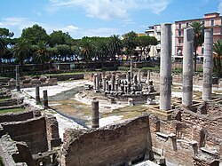
Macellum of Pozzuoli

Last updated
Frontispiece of Charles Lyell's Principles of Geology of 1830, "carefully reduced from that given by the Canonico Andrea de Jorio in his Ricerche sul Tempio di Serapide, in Puzzuoli. Napoli, 1820, which had been based on a drawing by John Izard Middleton. Charles Lyell - Pillars of Pozzuoli.jpg
Frontispiece of Charles Lyell's Principles of Geology of 1830, "carefully reduced from that given by the Canonico Andrea de Jorio in his Ricerche sul Tempio di Serapide, in Puzzuoli. Napoli, 1820, which had been based on a drawing by John Izard Middleton.

The Macellum of Pozzuoli (Italian : Macellum di Pozzuoli) was the macellum or market building of the Roman colony of Puteoli, now the city of Pozzuoli in southern Italy. When first excavated in the 18th century, the discovery of a statue of Serapis led to the building being misidentified as the city's serapeum or Temple of Serapis.

Contents

A band of borings or Gastrochaenolites left by marine Lithophaga bivalve molluscs on three standing marble columns indicated that these columns had remained upright over centuries while the site sank below sea level, then re-emerged. This puzzling feature was the subject of debate in early geology, and eventually led to the identification of bradyseism in the area, showing that the Earth's crust could be subject to gradual movement without destructive earthquakes.

Roman origins

The city of Dicearchia, founded by Greek refugees escaping dictatorship on Samos, was integrated into the Roman Empire as the city of Puteoli in 194 BC. [2] The macellum or food market was built between the late first and early second century AD, and restored during the third century AD under the Severan dynasty. [3]

The building was in the form of an arcaded square courtyard, surrounded by two-storey buildings. Shops lined the marble floored colonnade forming an arcade with 34 grey granite columns. The main entrance and vestibule were positioned on a main axis, which lined up across a tholos in the centre of the square to the exedra for worship which had a portico formed by four large cipollino marble columns. The exedra had three niches for statues of divinities giving protection to the market, including the sculpture of Serapis. The tholos in the centre of the square was a circular building standing on a podium reached by four symmetrically placed access stairways, with sixteen African marble columns supporting a domed vault. Marine animals decorated friezes around the base of the tholos. The courtyard had four secondary entrances on its longer sides, with latrines in the corners of the colonnade and four (probable) tabernae with their own external entrances as well as access from the arcade. [4]

Excavation and influence on geology

The macellum in 2004 Serapeum (Pozzuoli) -2.jpg
The macellum in 2004

King Charles of Naples had excavations carried out between 1750 and 1756, exposing the three large cipollino marble columns which gave the site its name of the "three column vineyard". [3] It attracted visits from antiquarians, among them William Hamilton whose Campi Phlegraei of 1776 showed a distant view of the buildings dry above sea level, [5] and John Soane who "Went to the Temple of Jupiter Serapis" on 1 January 1779 and made rough sketches, as well as a plan of the complex, possibly copied from another drawing. [6]

In 1798 Scipione Breislak described his fieldwork at the site in his Topografia fisica della Campania, and theorised about changes in sea level around that coast. He argued that the evidence did not support the suggestion of falling sea levels worldwide, but thought seismic explanations were inadequate as earthquakes notoriously shook buildings until they collapsed, and the columns were still standing. He concluded that there must have been undetectable movement of the crust of the Earth, but recognised that this was unsatisfactory as the cause could not be seen. [5] In 1802 John Playfair, in his Illustrations of the Huttonian Theory of the Earth, used Breislak's descriptions to support James Hutton's ideas of slow changes, attributing the differing heights of water around the columns to "oscillations" in the level of the land. [7]

Lithophaga molluscs bore into rocks or corals, forming shallow holes called Gastrochaenolites. Lithophaga.JPG
Lithophaga molluscs bore into rocks or corals, forming shallow holes called Gastrochaenolites .
View across the marketplace to two of the columns, showing the bands of mollusc holes. Pozzuoli 2010-by-RaBoe-15.jpg
View across the marketplace to two of the columns, showing the bands of mollusc holes.

Between 1806 and 1818 further excavations exposed the whole of the "Serapeum" or "Temple of Serapis". [3] The excavations lost stratigraphic information in the deposits which had buried the building, but the band of borings or Gastrochaenolites left by marine Lithophaga bivalves on the three standing marble columns provided a good record of relative sea level variation. [8]

The antiquarian Andrea di Jorio studied the ruins, and in 1817 published a guidebook to the Phlegraean Fields, with a map of the area which had many hot springs and volcanic craters as well as antiquarian sites including the supposed Temple. By this time the pavement was flooded by the sea, indicating a slight lowering of the land level. In 1820, he published a study of his Ricerche sul Tempio di Serapide, in Puzzuoli, including an illustration based on a drawing by John Izard Middleton showing the three columns with the bands affected by molluscs. [1] [5]

In 1819 Giovanni Battista Brocchi proposed that the columns below the bands had been protected from the molluscs by being buried in silt or volcanic ash. The first volume of Veränderungen der Erdoberfläche by Karl Ernst Adolf von Hoff, published in 1822, included an account of the ruins as demonstrating relative changes in land and sea level. Hoff's second volume of 1824 reviewed how earthquakes might have caused this, and mentioned Jorio's study. Hoff's account motivated Johann Wolfgang von Goethe to publish his own idea, coined when he visited the site in 1787. In Goethe's 1823 Architektonisch-naturhistorisches Problem, he suggested that silt or ash had partially buried the columns and at the same time held back water forming a lagoon above sea level. Robert Jameson had this paper translated for his Edinburgh journal, to oppose Playfair's views. Other naturalists thought this unlikely, as the fresh water lagoon would not have supported marine molluscs, and the sea was by then higher than at the time of Goethe's visit. [5]

In his 1826 book A Description of Active and Extinct Volcanoes, Charles Daubeny dismissed the implied sinking of the land by 30 feet (9.1 m) followed by almost as great a rise as unlikely, since "it is probable that not a single pillar of the temple would now retain its erect posture to attest the reality of these convulsions". Daubeny also doubted changing sea levels, so concluded that the bands of holes bored by molluscs must be due to local damming of water around the buildings. [9]

Fort of Sindree before the earthquake. PSM V02 D538 Fort of sindree.jpg
Fort of Sindree before the earthquake.

Charles Lyell's Principles of Geology of 1830 featured as its frontispiece a replication of di Jorio's illustration of the columns (shown above), [1] and a detailed section discussing their significance. [11] He strongly contested Daubeny's argument, and instead proposed slow and steady geological forces. Lyell wrote "That buildings should have been submerged, and afterwards upheaved, without being entirely reduced to a heap of ruins, will appear no anomaly, when we recollect that in the year 1819, when the delta of the Indus sank down, the houses within the fort of Sindree subsided beneath the waves without being overthrown." In 1832 the young Charles Darwin used Lyell's methods at the first landfall of the Beagle survey voyage, while considering evidence of land rising up at St. Jago. In his journal, Darwin dismissed Daubeny's argument, and wrote that he felt "sure at St Jago in some places a town might have been raised without injuring a house." [7]

Charles Babbage carried out a detailed survey of the ruins in 1828 and his Observations on the Temple of Serapis at Pozzuoli, near Naples were published in 1847. In some of the rooms of the macellum Babbage found a dark brownish encrustation of salts, and a thicker encrustation up to a height of about 9 feet (2.7 m) from floor level. These have been interpreted as showing that as the building lowered, a little lake formed and allowed water to enter the building without there being a direct connection to the sea, then at a later stage the land subsided to the point where sea water came in, and the Lithophaga started drilling holes in the masonry up to 19 feet (5.8 m) from floor level. [8]

The identification of the building as a macellum or marketplace rather than a temple was made by Charles Dubois, who published a detailed account of the ruins of Pozzuoli in his Pouzzoles antiques. Histoire et topographie of 1907. [3] [12]

Modern investigations

More recent investigations of the vertical movements have shown that the site is near the centre of the Campi Flegrei (Phlegraean Fields) caldera and has been subject to repeated "slow earthquakes" or bradyseism of this shallow caldera resulting in relatively slow subsidence over long periods, drowning the ruin, punctuated by periods of relatively rapid uplift that caused it to re-emerge. After a long subsidence through Roman times, there was a period of uplift in the Middle Ages around AD 700 to 800, then after more subsidence the land rose again from around 1500 up to the last eruption in 1538. The land again subsided gradually, then between 1969 and 1973 the land rose by about 1.7 metres (5.6 ft). Over the following decade there was a little subsidence, then between 1982 and 1994 there was uplift of almost 2 metres (6.6 ft). Concerns about risks of earthquake damage and possible eruption led to temporary evacuation of the city of Pozzuoli. Detailed measurements indicated that the caldera deformation formed a nearly circular lens centred near Pozzuoli. Various models have been produced to find mechanisms explaining this pattern. [13]

Ancient Roman market place and Serapis temple panorama - Pozzuoli - Campania - Italy - July 11th 2013.jpg
Panorama of the macellum

Related Research Articles

Priene Ancient Greek city of Ionia

Priene was an ancient Greek city of Ionia located at the base of an escarpment of Mycale, about 6 kilometres (3.7 mi) north of what was then the course of the Maeander River. It was 67 kilometres (42 mi) from ancient Anthea, 15 kilometres (9.3 mi) from ancient Aneon and 25 kilometres (16 mi) from ancient Miletus. The city was built on the sea coast, overlooking the former Latmian Gulf of the Aegean. It was developed on steep slopes and terraces extending from sea level to a height of 380 metres (1,250 ft) above sea level at the top of the escarpment. Because of siltation from the river filling the bay over several centuries, the city is now an inland site. It is located at a short distance west of the modern village Güllübahçe Turun in the Söke district of Aydın Province, Turkey.

Cumae Ancient Roman city near Naples, Italy

Cumae was the first ancient Greek colony on the mainland of Italy, founded by settlers from Euboea in the 8th century BC and soon becoming one of the strongest colonies. It later became a rich Roman city, the remains of which lie near the modern village of Cuma, a frazione of the comune Bacoli and Pozzuoli in the Metropolitan City of Naples, Campania, Italy.

Subsidence

Subsidence is a general term for downward vertical movement of the Earth's surface, which can be caused by both natural processes and human activities. Subsidence involves little or no horizontal movement, which distinguishes it from slope movement.

Bradyseism Motion of Earths surface caused by volcanic activity

Bradyseism is the gradual uplift or descent of part of the Earth's surface caused by the filling or emptying of an underground magma chamber or hydrothermal activity, particularly in volcanic calderas. It can persist for millennia in between eruptions and each uplift event is normally accompanied by thousands of small to moderate earthquakes. The word derives from the ancient Greek words βραδύς bradús, meaning "slow", and σεισμός seismós meaning "movement", and was coined by Arturo Issel in 1883.

Serapeum Temple dedicated to Serapis

A serapeum is a temple or other religious institution dedicated to the syncretic Greco-Egyptian deity Serapis, who combined aspects of Osiris and Apis in a humanized form that was accepted by the Ptolemaic Greeks of Alexandria. There were several such religious centers, each of which was a serapeion or, in its Latinized form, a serapeum. An Egyptian name for the temple of Osiris-Apis was Pr-Wsỉr-Ḥp "House of Osiris-Apis".

Pozzuoli City and comune of the Metropolitan City of Naples, in the Italian region of Campania

Pozzuoli is a city and comune of the Metropolitan City of Naples, in the Italian region of Campania. It is the main city of the Phlegrean Peninsula.

Phlegraean Fields A supervolcano located west of Naples, Italy

The Phlegraean Fields is a large volcano situated to the west of Naples, Italy. It was declared a regional park in 2003. The area of the caldera consists of 24 craters and volcanic edifices; most of them lie under water. Hydrothermal activity can be observed at Lucrino, Agnano and the town of Pozzuoli. There are also effusive gaseous manifestations in the Solfatara crater, the mythological home of the Roman god of fire, Vulcan. This area is monitored by the Vesuvius Observatory.

Sabratha city in Libya

Sabratha, in the Zawiya District of Libya, was the westernmost of the ancient "three cities" of Roman Tripolis, alongside Oea and Leptis Magna. From 2001 to 2007 it was the capital of the former Sabratha wa Sorman District. It lies on the Mediterranean coast about 70 km (43 mi) west of modern Tripoli. The extant archaeological site was inscribed as a UNESCO World Heritage Site in 1982.

Canopus, Egypt

Canopus, also known as Canobus, was an ancient Egyptian coastal town, located in the Nile Delta. Its site is in the eastern outskirts of modern-day Alexandria, around 25 kilometers (16 mi) from the center of that city. Canopus was located on the western bank at the mouth of the westernmost branch of the Delta – known as the Canopic or Heracleotic branch. It belonged to the seventh Egyptian Nome, known as Menelaites, and later as Canopites, after it. It was the principal port in Egypt for Greek trade before the foundation of Alexandria, along with Naucratis and Heracleion. Its ruins lie near the present Egyptian town of Abu Qir.

Macellum

A macellum is an ancient Roman indoor market building that sold mostly provisions. The building normally sat alongside the forum and basilica, providing a place in which a market could be held. Each macellum sold different kinds of produce, depending on local availability, but it was not uncommon to import these comestibles, especially at ports like Pompeii.

Licola, Pozzuoli Frazione in Campania, Italy

Licola is an area in the province of Naples which takes its name from Lago dei Follicoli, a lake which formerly occupied most of the area. The current population of Licola ranges between 4,000 and 5,000. Licola is a strip of land facing the sea, and is roughly three kilometers by ten kilometers in size. It begins at the foot of Mount Cuma and ends in Marina di Varcaturo.

<i>The Structure and Distribution of Coral Reefs</i> Book published in 1842 by Charles Darwin

The Structure and Distribution of Coral Reefs, Being the first part of the geology of the voyage of the Beagle, under the command of Capt. Fitzroy, R.N. during the years 1832 to 1836, was published in 1842 as Charles Darwin's first monograph, and set out his theory of the formation of coral reefs and atolls. He conceived of the idea during the voyage of the Beagle while still in South America, before he had seen a coral island, and wrote it out as HMS Beagle crossed the Pacific Ocean, completing his draft by November 1835. At the time there was great scientific interest in the way that coral reefs formed, and Captain Robert FitzRoy's orders from the Admiralty included the investigation of an atoll as an important scientific aim of the voyage. FitzRoy chose to survey the Keeling Islands in the Indian Ocean. The results supported Darwin's theory that the various types of coral reefs and atolls could be explained by uplift and subsidence of vast areas of the Earth's crust under the oceans.

Macellum of Pompeii Mall at the forum of Pompeii

The Macellum of Pompeii was located on the Forum and as the provision market of Pompeii was one of the focal points of the ancient city. The building was constructed in several phases. When the earthquake of 62 CE destroyed large parts of Pompeii, the Macellum was also damaged. Archeological excavations in the modern era have revealed a building that had still not been fully repaired by the time of the eruption of 79 CE.

1692 Jamaica earthquake 1692 earthquake and tsunami centered on Port Royal, British Jamaica

The 1692 Jamaica earthquake struck Port Royal, Jamaica, on 7 June. A stopped pocket watch found in the harbor during a 1959 excavation indicated that it occurred around 11:43 AM local time.

Aizanoi

Aizanoi, Latinized as Aezani, was an Ancient Greek city in western Anatolia. Located in what is now Çavdarhisar, near Kütahya, its ruins are situated astride the River Penkalas, some 1,000 m (3,300 ft) above sea level. The city was an important political and economic centre in Roman times; surviving remains from the period include a well-preserved Temple of Zeus, unusual combined theatre-stadium complex, and macellum inscribed with the Price Edict of Diocletian. The city fell into decline in Late Antiquity. Later serving as a citadel, in 2012 the site was submitted for inscription on the UNESCO World Heritage List.

1303 Hongdong earthquake earthquake in northern China (25 September 1303)

The 1303 Hongdong earthquake occurred in Yuan China of the Mongol Empire, on September 25. The shock was estimated to have a moment magnitude of 7.6 and it had a maximum Mercalli intensity of XI (Extreme). With catastrophic damage, it was one of the deadliest recorded earthquakes of all time.

Temple of Athena Pronaia

The Temple of Athena Pronaia was a temple at the ancient site of Delphi, in the Sanctuary of Athena Pronaia, a group of buildings comprising temples and treasuries as well as the famous Tholos of Delphi. There were in fact three successive temples built at the site. The earlier temples (38°28′49″N22°30′30″E), referred to as A and B, were built in the 7th and 6th centuries BC respectively and were made of porous stone; a third temple (38°28′49″N22°30′28″E) was built of limestone in the 4th century BC, although it is not certain that it actually was dedicated to Athena this time.

Campanian Ignimbrite eruption VEI 7.7-7.8 Volcanic eruption around 40,000 years BP

The Campanian Ignimbrite eruption was a major volcanic eruption in the Mediterranean during the late Quaternary, classified 7 on the Volcanic Explosivity Index (VEI). The event has been attributed to the Archiflegreo volcano, the 13-kilometre-wide (8.1 mi) caldera of the Phlegraean Fields, located 20 km (12 mi) west of Mount Vesuvius under the western outskirts of the city of Naples and the Gulf of Pozzuoli, Italy. Estimates of the date and magnitude of the eruption(s), and the amount of ejected material have varied considerably during several centuries the site has been studied. This applies to most significant volcanic events that originated in the Campanian Plain, as it is one of the most complex volcanic structures in the world. However, continued research, advancing methods, and accumulation of volcanological, geochronological, and geochemical data have improved the dates' accuracy.

Pozzuoli Cathedral

Pozzuoli Cathedral or the Basilica of San Procolo martire is the main Roman Catholic church in Pozzuoli and the seat of the Diocese of Pozzuoli. It sits at the top of the Rione Terra and is built around an ancient Roman temple.

References

  1. 1 2 3 Lyell 1830 , pp.  ii , xiv
  2. "Pozzuoli", Campania, In Italy today.
  3. 1 2 3 4 "Temple of Serapis -- History". Cultura Campania. RAI. Retrieved 9 July 2011.[ permanent dead link ]
  4. "Temple of Serapis -- Percorsi". Cultura Campania. RAI. Retrieved 9 July 2011.[ permanent dead link ]
  5. 1 2 3 4 Rudwick, MJS (2010). Worlds before Adam: the reconstruction of geohistory in the age of reform. Chicago: University of Chicago Press. pp. 106–13, 117. ISBN   978-0-226-73129-2.
  6. "Soane Drawings — Copy of a measured drawing". UK: Soane. Archived from the original on 26 March 2012. Retrieved 9 July 2011.
  7. 1 2 Herbert 2005 , pp. 152–5
  8. 1 2 Liber, Lucio; Paola Petrosino; Valentina Armiero (2010). "Il Serapeo ed i Granai Imperiali di Pozzuoli = The Serapis Temple and the Imperial Granaries of Pozzuoli". Italian Journal of Geosciences. 129 (2): 237–50. Retrieved 2011-07-09.
  9. Herbert 1991 , pp.  169–71
  10. "Popular Science Monthly, Earthquake Phenomena, Volume 02, March 1873" . Retrieved 21 December 2012.
  11. Lyell 1830 , pp.  449–60
  12. "Short Notices". The English Historical Review. Oxford University Press. 26 (102): 410–32. Apr 1911. JSTOR   550521.
  13. De Natale, G; Troise, C; Pingue, F; Mastrolorenzo G; Pappalardo L; Battaglia M; Boschi E (2006). "The Campi Flegrei caldera: unrest mechanisms and hazards". In Troise C, De Natale G & Kilburn CRJ (ed.). Mechanisms of activity and unrest at large calderas. Special Publications. Vol. 269. London: Geological Society. pp. 26–7. ISBN   978-1-86239-211-3 . Retrieved 14 July 2011.

Sources

Coordinates: 40°49′34″N14°07′14″E / 40.82611°N 14.12056°E / 40.82611; 14.12056