Clarion Municipal Airport is a city-owned public-use airport located one nautical mile (1.85 km) northwest of the central business district of Clarion, a city in Wright County, Iowa, United States. This airport is included in the FAA's National Plan of Integrated Airport Systems for 2009–2013, which categorized it as a general aviation facility.
Springdale Municipal Airport is a public use airport in Washington County, Arkansas, United States. It is owned by the City of Springdale and located one nautical mile (2 km) southeast of its central business district. This airport is included in the National Plan of Integrated Airport Systems for 2011–2015, which categorized it as a general aviation facility.
Columbus County Municipal Airport is a county-owned, public-use airport in Columbus County, North Carolina, United States. It is located three nautical miles (6 km) south of the central business district of Whiteville, North Carolina. This airport is included in the National Plan of Integrated Airport Systems for 2011–2015, which categorized it as a general aviation facility.
Mercer County Regional Airport is a public use airport in Mercer County, North Dakota, United States. It is located two nautical miles (4 km) east of the central business district of Hazen, North Dakota. The airport is owned by Mercer County and the cities of Hazen, Golden Valley, Pick City, Stanton and Zap. It is included in the National Plan of Integrated Airport Systems for 2011–2015, which categorized it as a general aviation facility.
Mena Intermountain Municipal Airport is a city-owned, public-use airport located two nautical miles (4 km) southeast of the central business district of Mena, a city in Polk County, Arkansas, United States. It is included in the National Plan of Integrated Airport Systems for 2011–2015, which categorized it as a general aviation facility.

Tillamook Airport is a public use airport located 3 miles (4.8 km) south of the central business district of Tillamook, a city in Tillamook County, Oregon, United States. It is owned by the Port of Tillamook Bay. According to the FAA's National Plan of Integrated Airport Systems for 2009–2013, it is categorized as a general aviation facility.
Atlantic Municipal Airport, is a city-owned public-use airport located two miles (3 km) west of the central business district of Atlantic, a city in Cass County, Iowa, United States. The airport has a runway opened in 2006 capable of handling light business jets.
Philadelphia Municipal Airport is a public use airport in Neshoba County, Mississippi, United States. It is owned by the City of Philadelphia and located two nautical miles (4 km) northwest of its central business district. This airport is included in the National Plan of Integrated Airport Systems for 2011–2015, which categorized it as a general aviation facility.
Shelbyville Municipal Airport is a public use airport located four nautical miles (7 km) northwest of the central business district of Shelbyville, in Shelby County, Indiana, United States. The airport is owned by the city of Shelbyville and is controlled by the mayor and an appointed Board of Commissioners. According to the FAA's National Plan of Integrated Airport Systems for 2009–2013, it was classified as a general aviation airport.
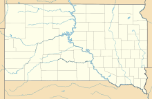
Britton Municipal Airport is a city-owned, public-use airport located two nautical miles northeast of the central business district of Britton, a city in Marshall County, South Dakota, United States. According to the FAA's National Plan of Integrated Airport Systems for 2009–2013, it is categorized as a general aviation airport.
Hot Springs Municipal Airport is a city-owned public-use airport located five nautical miles southeast of the central business district of Hot Springs, a city in Fall River County, South Dakota, United States. According to the FAA's National Plan of Integrated Airport Systems for 2009–2013, it is categorized as a general aviation facility.
Orange City Municipal Airport was a city-owned public-use airport located one nautical mile (1.85 km) south of the central business district of Orange City, a city in Sioux County, Iowa, United States. This airport was included in the FAA's National Plan of Integrated Airport Systems for 2009–2013, which categorized it as a general aviation facility.
Southland Field is a public-use airport located five nautical miles (9 km) south of the central business district of Sulphur, a city in Calcasieu Parish, Louisiana, United States. It is owned by the West Calcasieu Airport Managing Board and is also known as West Calcasieu Airport.
Monroe Municipal Airport is a city owned public use airport located three nautical miles (6 km) northeast of the central business district of Monroe, a city in Green County, Wisconsin, United States. It is included in the Federal Aviation Administration (FAA) National Plan of Integrated Airport Systems for 2021–2025, in which it is categorized as a local general aviation facility.
Baker Municipal Airport is a public-use airport located one nautical mile southeast of the central business district of Baker, a city in Fallon County, Montana, United States. The airport is owned by Baker City and Fallon County. It is included in the FAA's National Plan of Integrated Airport Systems for 2011–2015, which categorized it as a general aviation facility.

Blytheville Municipal Airport is a public use airport located three nautical miles east of the central business district of Blytheville, in Mississippi County, Arkansas, United States. It is owned by the City of Blytheville.
Rugby Municipal Airport is a public use airport located two nautical miles (4 km) northwest of the central business district of Rugby, a city in Pierce County, North Dakota, United States. It is owned by the Rugby Airport Authority. This airport is included in the National Plan of Integrated Airport Systems for 2011–2015, which categorized it as a general aviation facility.
Pauls Valley Municipal Airport is a city-owned, public-use airport located two nautical miles (4 km) south of the central business district of Pauls Valley, a city in Garvin County, Oklahoma, United States. It is included in the National Plan of Integrated Airport Systems for 2011–2015, which categorized it as a general aviation facility.
Tahlequah Municipal Airport is a city-owned, public-use airport located two nautical miles (4 km) northwest of the central business district of Tahlequah, a city in Cherokee County, Oklahoma, United States. It is included in the National Plan of Integrated Airport Systems for 2011–2015, which categorized it as a general aviation facility.
Miller Municipal Airport is a city-owned, public-use airport located two nautical miles (4 km) east of the central business district of Miller, a city in Hand County, South Dakota, United States. It is included in the National Plan of Integrated Airport Systems for 2011–2015, which categorized it as a general aviation facility.