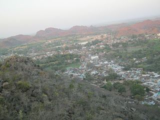
Ajaigarh or Adjygurh is a town and a nagar panchayat in the Panna District of Madhya Pradesh state in central India.
Bundelkhand is a geographical and cultural region and also a mountain range in central & North India. The hilly region is now divided between the states of Uttar Pradesh and Madhya Pradesh, with the larger portion lying in the latter state.

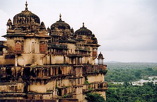
Orchha is a town in Niwari district of Madhya Pradesh state, India. The town was established by Rudra Pratap Singh some time after 1501, as the seat of an eponymous former princely state of covering parts of central & north India, in the Bundelkhand region. Orchha lies on the Betwa River, 80 km from Tikamgarh & 15 km from Jhansi in Uttar Pradesh.

Chhatarpur is a city and a municipality in Chhatarpur district in the state of Madhya Pradesh, India. It is the administrative headquarters of Chhatarpur District.
Panna is a city and a municipality in Panna district in the Indian state of Madhya Pradesh. It is famous for its diamond mines. It is the administrative center of Panna District.
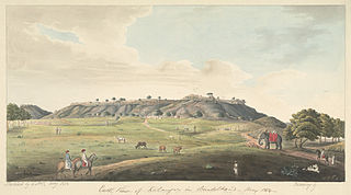
{{Infobox | title = Kalinjar Fort Precincts | image = [[File:'Henumaan Ka
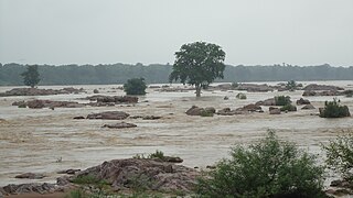
The Ken River, is one of the major rivers of the Bundelkhand region of central India, and flows through two states, Madhya Pradesh and Uttar Pradesh. It is a tributary of the Yamuna.
Satna is a city in the Indian state of Madhya Pradesh. It serves as the headquarters of Satna district and is the 8th most populous city of the state. The city is 500 km east of the state capital of Bhopal. The city is distributed over a land area of 111.9 square kilometres.

The Bundelas are a Rajput clan of central India. The families belonging to this clan ruled several small states in the Bundelkhand region from the 16th century.

Kulpahar is a city in Mahoba district in the Indian state of Uttar Pradesh. It is a historical town in the Bundelkhand region. Before 11 Feb 1995 Kulpahar was a Tehsil of Hamirpur District. On 11 Feb 1995 Mahoba District was carved out of Hamirpur, and Kulpahar is now a part of the Mahoba District. Kulpahar is the largest Subdivision of Uttar Pradesh. Kulpahar is known for its closeness to Khajuraho and other historic places like Mahoba, Charkhari, Kalinjar Rath, Orchha, and Jhansi. This town holds relics of temples and man-made water bodies of the Chandela Dynasty
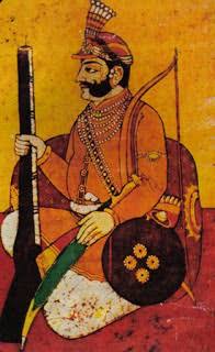
Maharaja Chhatrasal was a medieval Indian warrior from the Bundela Rajput clan who fought against the Mughal Empire, and established his own kingdom in Bundelkhand.
Bada Malhera, is a town in the Chhatarpur district of the state of Madhya Pradesh, India.
Pawai is a town and a nagar panchayat in the Panna district of Madhya Pradesh state in central India. It is mostly surrounded by rocky area.

Rajnagar is a city/town and Nagar Panchayat in Chhatarpur district in the Indian state of Madhya Pradesh,it is 6 km from Khajuraho,5 km from khajwa town and 35 km from district headquarters Chhatarpur.

Maharaja Chhatrasal Museum is a museum located in an old palace at Dhubela, on the Chhatarpur-Jhansi highway, in Chhatarpur District, Madhya Pradesh, India. This museum was established in September, 1955 in a palace built by Chhatrasal. Presently, the museum comprises 8 galleries, of which two galleries display inscriptions, copper plates, Sati pillars, lingas and inscribed images of the Gupta and Kalachuri period. The museum houses a wide range of sculptures of the Shakti cult. It has also a significant collection of Jaina images. It also displays the garments, weapons and paintings of the Bundela kings.
Nowgong is a city of Chhatarpur district of Madhya Pradesh. The town had a population of 11,507 in 1952. Vindhya Pradesh was merged into Madhya Pradesh on 1 November 1956. Nowgaon was declared capital of Madhya Pradesh, but after six month Bhopal became the capital of Madhya Pradesh.
Lavkushnagar, formerly known as Laundi, is a town/city/tehshil and a nagar panchayat in Chhatarpur district in the Indian state of Madhya Pradesh. It is about 55 km away from Chhatarpur and 37 km from the temple town Khajuraho. The Urmil and Kail Rivers flow through this town. The Civil Airport Khajuraho and Dumra, Harpalpur, and Khajuraho Railway Station are located nearby, and links it to some major towns and cities of Madhya Pradesh. It also has a Civil Court, a Sub Jail, and a police station.

Khajuraho railway station is located in Chhatarpur district of Madhya Pradesh and serves as an entry point for the Khajuraho Group of Monuments, medieval Hindu famous for their erotic sculptures. Between 950 and 1150, the Chandela monarchs built these temples.

Chhatarpur was one of the princely states of India during the period of the British Raj. The state was founded in 1785 and its capital was located in Chhatarpur, Madhya Pradesh.

Jigni State was a princely state of the Bundelkhand Agency of the British Raj. It was a small Sanad state of about 82.87 km2 with a population of 4,297 inhabitants in 1901. The state was surrounded by the Hamirpur and Jhansi districts of the United Provinces.