
Dhule is a city located in the Dhule District in the northwestern part of Maharashtra state, India known as West Khandesh. Situated on the banks of Panzara River, Dhule is the regional headquarters of MIDC, RTO, and MTDC.

Nandurbar district is an administrative district in the northwest corner of Maharashtra state in India. On 1 July 1998 Dhule was bifurcated as two separate districts now known as Dhule and Nandurbar. Nandurbar is a tribal-dominated district, The district headquarters are located at Nandurbar city. The district occupies an area of 5,955 square kilometres (2,299 sq mi) and has a population of 1,648,295 of which 16.71% were urban.

Shahada is a town in Nandurbar district of the Indian state of Maharashtra. It is a Municipal council. It is the second biggest town and the biggest Tehsil in Nandurbar district
Dhule district is a district of Maharashtra, India. The city of Dhule is the administrative headquarters of the district. It is part of North Maharashtra.
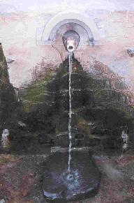
Unapdev is in Shahada, Dist. Nandurbar, Maharashtra tahsil located near the village Dara. It has a permanent natural hot water source.
Shirpur is a town and taluka in Dhule district of Nashik Division, Maharashtra, India. It is located on National Highway 3, which runs from Agra in Uttar Pradesh to Mumbai, Maharashtra. The Arunavati River and Tapi river flows through the city. Shirpur is 50 km from the city of Dhule. It houses Asia's largest and India's first gold refinery. Narsee Monjee Institute of Management Studies has a campus in Shirpur. Ahead of Shirpur there is a small private airport at Village Tande.
Shindkheda is a taluka in the Dhule district of Khandesh region of Maharashtra state in India. The city is situated on the west side of the Burai River.
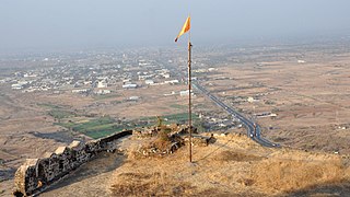
Toranmal is a Hill Station in the municipal council of the Nandurbar district in the Indian state of Maharashtra. One can reach through Shahada. It is a hill station located in the Satpura Range. Its Gorakhnath Temple is the site of a Yatra attended by thousands of devotees on Mahashivratri. On that occasion pilgrims walk barefoot for days from surrounding areas in the Nandurbar district but also from Maharashtra, Madhya Pradesh and Gujarat. Toranmal is the prominent hill station of Khandesh region.
State Highway 10, commonly referred to as MH SH 10, is a normal state highway that runs south through Pune, Ahmednagar, Nashik and Dhule districts in the state of Maharashtra, India. This state highway touches the cities of Dondaicha, Shevade, Mehergaon, Kusumbe, Malegaon, Manmad, Yeola, Kopargaon, Shirdi Rahata, Rahuri, Ahmednagar, Kashti, and Daund.
Maharashtra State Highway 151, commonly referred to as SH 151, is a state highway that runs south through Solapur district in the state of Maharashtra. This state highway touches the cities of Barshi – Vairag – Solapur – Akkalkot and then proceeds south towards Maharashtra-Karnataka state border.
Sarangkheda is a village in Shahada taluka in Nandurbar district of Maharashtra state in India. Sarangkheda village is situated around 15 km South of Shahada on the bank of Tapti River.
Savalde is a village in Shahada taluka in Nandurbar district of Maharashtra state in India. Savalde village is situated around 5 km South-west of Shahada, situated on the bank of river Tapti(Tapi) and on state border of states of Maharashtra and Gujarat.
Maharashtra State Highway 1, commonly referred to as MH SH 1, is a normal state highway that runs south through Nandurbar, Dhule and Jalgaon districts in the state of Maharashtra. This state highway touches numerous cities and villages VIZ. Shahada, Sangvi, Lasur and Amalner.
Maharashtra State Highway 2,, is a state highway in northern Maharashtra. This nomenclature is adopted for a short 55-kilometer state highway; the route is as follows : Mhasavad – Islampur – Lakkadkot – Ranipur – Nagziri – Toranmal. It connects the above-mentioned villages to the tehsil headquarter at Shahada. The traffic on the route being limited, it's designed for light two-way traffic only.
Kukarmunda is one of the seven Talukas that form the Tapi district of Gujarat and Administrative Headquarter of Kukarmunda Taluka. It is located by the Tapi river basin, south of the Satpura hill range.
Nizar (Nijhar) is one of the 7 tehsils in Tapi district in the Indian state of Gujarat. Nizar was separated from Surat district in 2007 while Tapi district was formed. Nizar is located in the South Gujarat, about 172 km from Surat bordering Nandurbar district of Maharashtra.The official language is Gujarati.
Manjrod is a village in a Shirpur Taluka of Dhule district, Maharashtra. It is located on bank of Tapi river. Manjrod is 70 km from the city of Dhule. The major occupation of the people is agriculture with cotton as the major product.
'Sagbara is a Town in Sagbara Taluka in Narmada District of Gujarat State, India. It is located 55 KM towards South from District head quarters Rajpipla. It is a Taluka head quarter.. Its location is at NH-753B Ankleshwar-Valia-Netrang-Dediapada-Sagbara up to State Border to Akkalkuva in Maharashtra
Maharashtra Major State Highway 9 also MSH 9 is a Major State Highway that runs south through Nagpur, and Chandrapur districts in the state of Maharashtra. This state highway touches numerous cities and villages VIZ. Nagpur, Umred, Nagbhid, Mul and Chandrapur. Tadoba Andhari Tiger Project and Umred Karhandla Wildlife Sanctuary are along with this highway.
Maharashtra Major State Highway 10, commonly referred to as MH or MSH-10, is a major state highway that runs north east through Amravati districts in the state of Maharashtra. This state highway touches numerous cities and villages Viz. Nandgoan, Morshi, Warud and then proceeds north-west towards Maharashtra-Madhya Pradesh state border. This highway enters in Madhya Pradesh State near Bangoan village which is on border of Amravati district of Maharashtra and Chhindwara district of Madhya Pradesh and ends at Bangoan village which is just 15 km East of Pandhurna in Madhya Pradesh.
