State Highway 42 (Maharashtra)

Last updated

State Highway 42 (Maharashtra).svg
State Highway 42
ghodbunder road thane
State Highway 42 (Maharashtra)
Thane ghodbunder road marked in Red on Thane area map
Ghodbunder Road (SH 42) (2319282008).jpg
Aerial view of Ghodbunder Road near Gaimukh
Route information
Maintained by MSRDC
Major junctions
From Kapurbawdi, Thane
Major intersections National Highway 3
National Highway 8
To Ghodbunder, Thane
Location
Country India
State Maharashtra
Districts Thane
Highway system
State Highways in Maharashtra

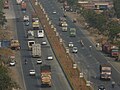
Maharashtra State Highway 42, commonly referred to as Ghodbunder Road or G.B. Road, runs entirely through the district of Thane. It is one of the major roads leading out of Thane city and connects to the Eastern Express Highway coming from south at Kapurbawdi, which joins National Highway 3 at this junction from North-East. It also connects to the Western Express Highway coming from south at Ghodbunder village, which later joins National Highway 8 at this junction traveling Northwards towards Gujarat.

Contents

General information

Maharashtra State Highway 42 is approximately 20 km long and links the two main arterial roads of Mumbai, the Eastern Express Highway and the Western Express Highway. It connects to Eastern Express Highway at Kapurbawdi village and Western Express Highway at Ghodbunder village. The Kapurbawdi bridge has been constructed to ease the traffic congestion. [1] This highway is tolled by the MSRDC. [2] This road skirts the northern boundary of Salsette Island providing scenic views of the Yeoor hills and the Thane creek.

Ghodbunder fort ruins Ghodbunder Fort.jpg
Ghodbunder fort ruins

Ghodbunder Road cuts across dense forests which form part of the Sanjay Gandhi National Park. It also skirts the Vasai Creek for most of its route and overlooks the forest from across the creek. In spite of development encroaching on the forest, much of flora and fauna continue to survive and prosper. Ghodbunder Road is lined with numerous historical monuments like the Ghodbunder Fort. Naglakot, Gaimukh Gadi and Firangkot, which although damaged now, unfolds stories of the 1500 century era reign of the Portuguese. [3]

This road once played a crucial role in Indo-Arab trade and later the Portuguese used it to monopolise sea routes in the Arabian Sea, at one point acted as a bridge between distant cultures. Several empires fought wars to control it. The Persian horses that came from the Arab countries used to land in the port (bunder) at the west end of this road. Hence, it initially came to be known as Ghodegaon (horse village). Around the time of Chhatrapati Shivaji, the road was renamed as Ghodbunder Road after the port. [4]

Locals say that till 1950, it was only a dirt road with residents of centuries old villages like Waghbil, Majhiwada, Patlipada, Ghodbunder, Kolshet and Kasarwadavli using bullock carts for transport. The surrounding forests had considerable plants like cashew, mangoes that were brought in by the Portuguese. The area was very rich in flora and fauna. [4]

Mumbai Metro Line 4 (Upcoming)

Green Line 4 of the Mumbai Metro, currently under construction, is part of the metro system for the city of Mumbai, India and is being developed by MMRDA and a consortium of international companies. [5]

The 32.32 km (20.08 mi) line is planned to be fully elevated, and is expected to consist of 32 stations from Wadala, Mumbai to Kasarvadavali via Ghatkopar, Mulund. It is estimated to cost 14,549 crore (US$1.8 billion) (₹145.49 billion). [6] Its construction was expected to begin by June 2018.

It is expected to be completed in 2022 and is expected to provide interconnectivity among the existing Eastern Express Highway, Central Railway, Mono Rail, the ongoing Metro Line 2B (D N Nagar to Mandale), and the proposed Metro Line 5 (Thane to Kalyan), Metro Line 6 (Swami Samarth Nagar to Vikhroli) and Metro Line 11 (Wadala to CSMT). It will provide rail based access to the commercial, government bodies and geographical landmarks in Mumbai. It will reduce the current travel time by between 50% and 75% depending on road conditions.

Major junctions

The following roads either emanate from it or are crossed by it. This list has been separated by district and talukas for easy reading.

TalukaDistanceLocation of JunctionJunction
Thane District
Thane0 km (0 mi)Majiwada [7] NH3-IN.svg National Highway 3
104 km (65 mi)Ghodbunder [7] NH8-IN.svg National Highway 8

See also

Related Research Articles

<span class="mw-page-title-main">Thane</span> City in Maharashtra, India

Thane is a metropolitan city located on the northwestern side of the state of Maharashtra in India. It is an immediate neighbour of Mumbai city proper, and a part of the Mumbai Metropolitan Region. It is situated in the north-eastern portion of the Salsette Island.

Mulund is a suburb in the north-east of Mumbai, Maharashtra, India. It comes under zone railway station on the Central Railway line of the Mumbai Suburban Railway. It was first railway station of Mumbai Suburban district on the central railway line. Next station is, Thane railway station comes under Thane district. It is nestled alongside the foothills of the Sanjay Gandhi National Park with easy access to the Eastern Express Highway and Navi Mumbai through the Mulund-Airoli Bridge. Mulund marks the end of Mumbai city.

<span class="mw-page-title-main">Mumbai Metro</span> Rapid transit system in Mumbai, India

The Mumbai Metro is a rapid transit (MRT) system serving the city of Mumbai and the wider Mumbai Metropolitan Region in Maharashtra, India.

<span class="mw-page-title-main">Thane Creek</span> Neighbourhood in Mumbai, Maharashtra, India

Thane Creek is an inlet in the shoreline of the Arabian Sea that isolates the city of Mumbai from the Konkan region of the Indian mainland. It comprises the area between Mumbra Retibunder and the Mankhurd-Vashi Bridge. The creek is divided into two parts. The first part lies between Ghodbunder and Thane (Thana), a section from where the Ulhas river flows from the north of Mumbai Island to meet the Arabian Sea on the west. The second part of the waterway lies between the city of Thane and the Arabian Sea at Trombay / Uran, before the Gharapuri islands.

<span class="mw-page-title-main">Bandra Kurla Complex</span> Business district in Mumbai, India

The Bandra Kurla Complex is a business and residential district in the city of Mumbai, India. It is a prominent upscale commercial hub which commands some of the highest property rates in the country. According to MMRDA, the complex is the first of a series of "growth centres" created to "arrest further concentration" of offices and commercial activities in eastern parts of Mumbai. It has aided to decongest the CBD in South Mumbai while seeding new areas of planned commercial real estate in the metropolitan region.

Andheri ([ən̪d̪ʱeɾiː]) is a suburb in the western part of the city of Mumbai in India.

<span class="mw-page-title-main">Hiranandani Estate</span> Township in Maharashtra, India

Hiranandani Estate is an upmarket condominium-style township built by the Hiranandani Group in the city of Thane, a part of the Mumbai Metropolitan Area in Maharashtra. It is accessible via Ghodbunder Road which connects the Eastern Express Highway to the western suburbs of Borivali, Kandivali, and Mira Road.

<span class="mw-page-title-main">Western Express Highway</span> Motorway in Mumbai

The Western Express Highway, abbreviated to WEH, is a major north–south 8-10 lane arterial road in Mumbai, India, stretching from the suburb of Mira Road to Bandra. The 25.33 km (15.74 mi) highway begins near the Mahim Creek and extends to the Kashimira in the northern limit of the city till it connects National Highway 48 at Ghodbunder village. The road connects the city of Mumbai to its suburbs, including the Chhatrapati Shivaji Maharaj International Airport.

<span class="mw-page-title-main">Mumbai Monorail</span> Monorail system in India

MMRDA Mumbai Monorail is a monorail system in the city of Mumbai, Maharashtra, India, built as part of a major expansion of public transport in the city. The project is operated by the Mumbai Metropolitan Region Development Authority (MMRDA). In March 2023, after an uptick in ridership, the MMRDA ordered 10 new trains for the route.

<span class="mw-page-title-main">Mumbai Trans Harbour Link</span> Sea bridge in India

The Mumbai Trans Harbour Link, officially named as Shri Atal Bihari Vajpayee Trans Harbour Link and also known as Sewri–Nhava Sheva Trans Harbour Link and colloquially as Atal Setu, is a 21.8 km (13.5 mi) 6-lane elevated highway bridge, which connects Mumbai with Navi Mumbai, its satellite city. It is the longest sea bridge in India, and the world's 12th longest sea bridge. The bridge begins in Sewri, South Mumbai, crosses Thane Creek north of Elephanta Island, and terminates at Chirle near Nhava Sheva in Uran taluka, Navi Mumbai. The road is linked to the Mumbai–Pune Expressway in the east and to the under-construction Coastal Road in the west. The 6-lane highway is 27 meters in width, in addition to two emergency exit lanes, two edge strips, parallel crash barriers and noise barriers on both sides. The project costs a total of 17,843 crore (US$2.2 billion). The bridge has a capacity to handle 70,000 vehicles per day. Construction on the bridge began in April 2018, and was inaugurated by Prime Minister Narendra Modi on 12 January 2024.

The Mumbai Metropolitan Region Development Authority (MMRDA) is a body of the Government of Maharashtra that is responsible for preparation of Regional Plan for MMR and the infrastructure development of the Mumbai Metropolitan Region. The MMRDA was created on 26 January 1975 under the Mumbai Metropolitan Region Development Authority Act, 1974 Government of Maharashtra. The agency is responsible for planning and coordination of development activities in the Region.

Kannamwar Nagar is a locality situated in Vikhroli east, on eastern express highway. Kannamwar Nagar is on the eastern side of the Vikhroli railway station and is known for buildings built by MHADA. It is considered as one of the biggest housing colonies in India and one of the biggest workers housing colonies in Asia.

Kolshet is a locality in Thane.

<span class="mw-page-title-main">Jogeshwari–Vikhroli Link Road</span> Road in Mumbai

The Jogeshwari–Vikhroli Link Road (JVLR), is a 10.6-kilometre-long (6.6 mi) 6-lane road with a central median in Mumbai which connects the Western Express Highway and Eastern Express Highway providing speedier access from Jogeshwari in the Western Suburbs to Vikhroli in the Eastern Suburbs. It was opened to traffic in 1994, and widened from two to six lanes in 2012 at a cost of 221.45 crore. The under-construction Line 6 of the Mumbai Metro is being constructed on this link road.

<span class="mw-page-title-main">Line 2 (Mumbai Metro)</span> Metro line of the Mumbai Metro

Line 2 (Yellow Line) of the Mumbai Metro is a rapid transit metro line in the city of Mumbai, Maharashtra, India. The line connects Dahisar in the northwest with Mandale in Mankhurd via Andheri, BKC and Chembur in the east. Phase One of Line 2A was partially opened on 2 April 2022 from Dahisar East to Dahanukarwadi.

<span class="mw-page-title-main">Line 4 (Mumbai Metro)</span> Indian rail transit line under construction

Line 4 (Green Line) of the Mumbai Metro is an unfinished rapid transit line in Mumbai, Maharashtra, India.

<span class="mw-page-title-main">Line 9 (Mumbai Metro)</span> Metro line in Mumbai, India

Red Line 9 (extension) of the Mumbai Metro is part of the metro system for the city of Mumbai, India. Metro Line 9 is an extension of the Red Line from Andheri to CSMIA and Dahisar to Mira Road. This line will be unique from the other metro lines because it will run on a double-decker bridge. There will be a flyover on the first deck and the metro will run on the second deck. The flyover will start near the proposed Shivaji Chowk metro station and will end in Bhayander (West) via Mira Bhayander Road. It shall provide interconnectivity among the Western Express Highway, the Western Line, and the Mumbai Metro.

<span class="mw-page-title-main">Line 5 (Mumbai Metro)</span> Metro line in Mumbai, India

Line 5 (Orange Line) of the Mumbai Metro is a rapid transit metro line in the city of Mumbai, Maharashtra, India. When completed, the 24.9 km (15.5 mi) line will connect Thane with Kalyan via Bhiwandi, with 17 stations. The line will be fully elevated except for a 3 km underground section in Bhiwandi.

<span class="mw-page-title-main">Line 6 (Mumbai Metro)</span> Metro line in Mumbai, India

Line 6 (Pink Line) of the Mumbai Metro is a rapid transit metro line in the city of Mumbai, Maharashtra, India. The 14.477 km (8.996 mi) elevated line will connect Lokhandwala Complex with Vikhroli and will have 13 stations.

References

  1. "dna exclusive: 767-metre-long Kapurbawdi flyover opening on Nov 15 in Mumbai". dna. 26 October 2013. Retrieved 21 January 2019.
  2. Tripathi, Vedika (10 November 2008). "Ghodbunder Road toll naka gives chocolates, not change". Mid-Day . Mumbai. Retrieved 24 May 2015.
  3. "Ghodbunder Road Development Plan". hiranandani.com. 1 January 2017.
  4. 1 2 "Ever busy Ghodbunder Road in Thane was once a route for Arabian horses". indianexpress.com. 11 January 2018.
  5. "Mumbai Metro line 4 - current status". www.mmrda.maharashtra.gov.in/. MMRDA official website. Retrieved 15 November 2018.
  6. "Everything you need to know about Metro 2B and Metro 4 | Free Press Journal". Free Press Journal. Retrieved 12 February 2017.
  7. 1 2 "National Highway 3 intersection with State Highway 10 at Malegaon Taluka". Mahapwd.com. Retrieved 22 October 2012.[ dead link ]