Makikihi

Last updated

Makikihi
Mākikihi
Rural settlement
Makikihi
Coordinates: 44°37′52″S171°08′31″E / 44.631°S 171.142°E / -44.631; 171.142
Country New Zealand
Region Canterbury
Territorial authority Waimate District
WardPareora-Otaio-Makikihi Ward
Electorates
Government
  Territorial authority Waimate District Council
  Regional council Environment Canterbury
   Mayor of Waimate Craig Rowley
   Waitaki MP Miles Anderson
   Te Tai Tonga MP Tākuta Ferris
Area
[1]
  Total0.33 km2 (0.13 sq mi)
Population
 (June 2023) [2]
  Total90
  Density270/km2 (710/sq mi)
Time zone UTC+12 (New Zealand Standard Time)
  Summer (DST) UTC+13 (New Zealand Daylight Time)
Area code 03

Makikihi is a small town in the Waimate District of south Canterbury region of New Zealand's South Island. It is located on State Highway 1 12.2 kilometres south of Saint Andrews, Canterbury, and 15.5 kilometres northeast of Waimate. It is close to the mouth of Makikihi River. [3]

Contents

Demographics

Makikihi is described as a rural settlement by Statistics New Zealand, and covers 0.33 km2 (0.13 sq mi). [1] It had an estimated population of 90 as of June 2023, [2] with a population density of 273 people per km2. The settlement is part of the larger Makikihi-Willowbridge statistical area.

Historical population for Makikihi
YearPop.±% p.a.
200672    
201372+0.00%
201884+3.13%
Source: [4]

Makikihi had a population of 84 at the 2018 New Zealand census, an increase of 12 people (16.7%) since the 2013 census, and an increase of 12 people (16.7%) since the 2006 census. There were 30 households, comprising 45 males and 36 females, giving a sex ratio of 1.25 males per female. The median age was 47.7 years (compared with 37.4 years nationally), with 9 people (10.7%) aged under 15 years, 12 (14.3%) aged 15 to 29, 39 (46.4%) aged 30 to 64, and 21 (25.0%) aged 65 or older.

Ethnicities were 85.7% European/Pākehā, 10.7% Māori, 3.6% Pasifika, and 10.7% other ethnicities. People may identify with more than one ethnicity.

Although some people chose not to answer the census's question about religious affiliation, 50.0% had no religion, and 32.1% were Christian.

Of those at least 15 years old, 3 (4.0%) people had a bachelor's or higher degree, and 21 (28.0%) people had no formal qualifications. The median income was $21,400, compared with $31,800 nationally. 3 people (4.0%) earned over $70,000 compared to 17.2% nationally. The employment status of those at least 15 was that 36 (48.0%) people were employed full-time, 9 (12.0%) were part-time, and 3 (4.0%) were unemployed. [4]

Makikihi-Willowbridge statistical area

The Makikihi-Willowbridge statistical area includes Hook and Studholme, and extends to Waimate but does not include it. It covers 295.03 km2 (113.91 sq mi) [1] and had an estimated population of 1,090 as of June 2023, [5] with a population density of 3.7 people per km2.

Historical population for Makikihi-Willowbridge
YearPop.±% p.a.
2006984    
2013993+0.13%
20181,008+0.30%
Source: [6]

Makikihi-Willowbridge had a population of 1,008 at the 2018 New Zealand census, an increase of 15 people (1.5%) since the 2013 census, and an increase of 24 people (2.4%) since the 2006 census. There were 396 households, comprising 543 males and 465 females, giving a sex ratio of 1.17 males per female. The median age was 46.5 years (compared with 37.4 years nationally), with 171 people (17.0%) aged under 15 years, 150 (14.9%) aged 15 to 29, 498 (49.4%) aged 30 to 64, and 189 (18.8%) aged 65 or older.

Ethnicities were 89.9% European/Pākehā, 6.8% Māori, 1.5% Pasifika, 5.1% Asian, and 1.8% other ethnicities. People may identify with more than one ethnicity.

The percentage of people born overseas was 16.4, compared with 27.1% nationally.

Although some people chose not to answer the census's question about religious affiliation, 49.1% had no religion, 41.4% were Christian, 0.3% were Buddhist and 0.6% had other religions.

Of those at least 15 years old, 99 (11.8%) people had a bachelor's or higher degree, and 198 (23.7%) people had no formal qualifications. The median income was $31,800, compared with $31,800 nationally. 138 people (16.5%) earned over $70,000 compared to 17.2% nationally. The employment status of those at least 15 was that 450 (53.8%) people were employed full-time, 144 (17.2%) were part-time, and 21 (2.5%) were unemployed. [6]

Education

Makikihi School is a full primary school serving years 1 to 8, [7] with a roll of 27 students as of February 2024. [8] The school opened in 1881. [9]

Related Research Articles

<span class="mw-page-title-main">Waitomo District</span> Territorial authority district in Waikato region, New Zealand

Waitomo District is a territorial authority, located in the Waikato region, at the north of the King Country area in the North Island of New Zealand. A small part of the district, the locality of Tiroa, however, lies in the Manawatū-Whanganui region.

<span class="mw-page-title-main">Central Hawke's Bay District</span> Territorial authority district in Hawkes Bay, New Zealand

Central Hawke's Bay District is in the Hawke's Bay Region in the North Island of New Zealand. Formed in 1989, it covers an area of 3,333 square kilometres, from Pukehou in the north to Takapau in the south, and from the western Ruahine Range to the Pacific coast in the east. It has a population of 16,000, up from 14,142 in the 2018 census and 12,717 in the 2013 census.

<span class="mw-page-title-main">Kingston, New Zealand</span> Rural settlement in Otago, New Zealand

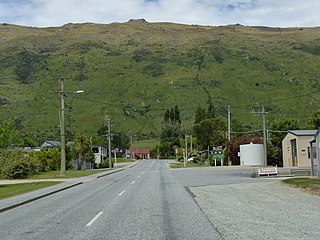
Kingston is a small town at the southernmost end of Lake Wakatipu, just north of the border of Otago and Southland, in New Zealand's South Island. It is 47 kilometres south of Queenstown by a road, "The Devil's Staircase", which winds between the lake to the west and The Remarkables mountains to the east. It is 70 kilometres north of Lumsden, and close to the headwaters of the Mataura River.

<span class="mw-page-title-main">Pauanui</span> Place in Waikato, New Zealand

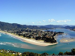
The town of Pauanui is on the east coast of the Coromandel Peninsula in the North Island of New Zealand. It lies at the mouth of the Tairua River on its south bank, directly opposite the larger town of Tairua.

<span class="mw-page-title-main">South Taranaki District</span> Territorial authority district in Taranaki, New Zealand

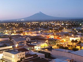
South Taranaki is a territorial authority on the west coast of New Zealand's North Island that contains the towns of Hāwera, Manaia, Ōpunake, Patea, Eltham, and Waverley. The District has a land area of 3,575.46 km2 and a population of 29,600. It is part of the greater Taranaki Region.

<span class="mw-page-title-main">Purau</span> Settlement in Canterbury, New Zealand

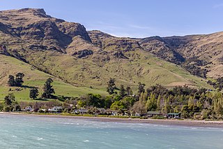
Purau is a small town in Canterbury, New Zealand, facing Lyttelton Harbour.

<span class="mw-page-title-main">Hawarden, New Zealand</span> Town in Canterbury, New Zealand

Hawarden is a small town in the Canterbury region of New Zealand's South Island. It is located near Waikari, just off State Highway 7.

<span class="mw-page-title-main">Rotherham, New Zealand</span> Town in Canterbury, New Zealand

Rotherham is a small village in the Hurunui District of the Canterbury region in New Zealand's South Island. It is between Culverden and Waiau on the Inland Kaikōura Road, on the northernmost part of the Amuri Plain. It lies near the south bank of the Waiau Uwha River, a popular location for trout and salmon fishing.

<span class="mw-page-title-main">Ōhaeawai</span> Place in Northland Region, New Zealand

Ōhaeawai is a small village at the junction of State Highway 1 and State Highway 12 in the Far North District of New Zealand, some 250 km (160 mi) from Auckland. The town of Kaikohe is 10.4 km (6.5 mi) to the west, and the Bay of Islands is a short drive to the east.

Waipapa is a small town in the Bay of Islands, Northland, New Zealand. It is located on State Highway 10, approximately 10 minutes drive from Kerikeri, the nearest urban centre. Waipapa itself has no school with most pupils travelling to Kerikeri on a daily basis. It is governed by the Far North District council.

<span class="mw-page-title-main">Tuamarina</span> Town in Marlborough, New Zealand

Tuamarina is a small town in Marlborough, New Zealand. State Highway 1 runs through the area. The Tuamarina River joins the Wairau River just south of the settlement. Picton is about 18 km to the north, and Blenheim is about 10 km to the south.

<span class="mw-page-title-main">Luggate</span> Town in the South Island of New Zealand

Luggate is a small town in the South Island of New Zealand. It is located on State Highway 6 between Wānaka and Cromwell, near the junction with State Highway 8A, approximately 15 km from the Wānaka township, just past Wānaka Airport.

<span class="mw-page-title-main">Saint Andrews, Canterbury</span> Rural settlement in Canterbury, New Zealand

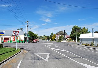
St Andrews is a small town in the south Canterbury region of New Zealand's South Island. It is located on State Highway 1 five kilometres south of Pareora and 17 kilometres south of Timaru. It was linked to Timaru by rail in 1876, and grew after the subdivision of the Pareora Run. It remains a rural service town.

<span class="mw-page-title-main">Waimate District</span> Territorial authority district in Canterbury Region, New Zealand

Waimate District is a territorial authority district located in the Canterbury Region of the South Island of New Zealand. The main town is Waimate, while there are many smaller rural communities dispersed throughout the area. Its boundary to the south is the Waitaki River, to the west Lake Benmore and to the north-east the Pareora River.

<span class="mw-page-title-main">Sandspit, New Zealand</span> Suburb in Auckland, New Zealand

Sandspit is a settlement in the Auckland Region of New Zealand. It is on the Mahurangi Peninsula, about 65 kilometres north of the city centre. It has experienced substantial increases in property values during the first two decades of the 21st century.

<span class="mw-page-title-main">Algies Bay</span> Suburb in Auckland Council, New Zealand

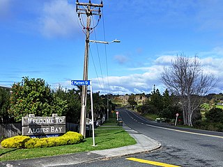
Algies Bay is a northern coastal suburb of Auckland, in New Zealand. It is on the Mahurangi Peninsula about 68 kilometres north of the city centre.

<span class="mw-page-title-main">Tanners Point</span> Rural settlement in the Bay of Plenty, New Zealand

Tanners Point is a rural settlement in the Western Bay of Plenty District and Bay of Plenty Region of New Zealand's North Island. It is on a headland on the eastern side of Tauranga Harbour, opposite Katikati Entrance.

Hiwinui is a settlement in Manawatū District, in the Manawatū-Whanganui region in New Zealand's central North Island.

Marlborough Ridge is a subdivision of Fairhall in Marlborough, New Zealand. It is located directly west of Marlborough Golf Course, and was developed from the late 1990s. Marlborough Ridge Reserve is a small park in the subdivision.

<span class="mw-page-title-main">Rainbows End, New Zealand</span> Place in Auckland Region, New Zealand

Rainbows End is a rural settlement at the end of Green Road between the Oak River and Matakana River in Auckland Region. Matakana is 4.5 km (2.8 mi) to the north. Sandspit is across the Oak River directly south.

References

  1. 1 2 3 "ArcGIS Web Application". statsnz.maps.arcgis.com. Retrieved 29 January 2024.
  2. 1 2 "Subnational population estimates (RC, SA2), by age and sex, at 30 June 1996-2023 (2023 boundaries)". Statistics New Zealand . Retrieved 25 October 2023. (regional councils); "Subnational population estimates (TA, SA2), by age and sex, at 30 June 1996-2023 (2023 boundaries)". Statistics New Zealand . Retrieved 25 October 2023. (territorial authorities); "Subnational population estimates (urban rural), by age and sex, at 30 June 1996-2023 (2023 boundaries)". Statistics New Zealand . Retrieved 25 October 2023. (urban areas)
  3. Harriss, Gavin (July 2021). "NZ Topo Map" (Map). Makikihi, Canterbury.
  4. 1 2 "Statistical area 1 dataset for 2018 Census". Statistics New Zealand. March 2020. 7027601.
  5. "Population estimate tables - NZ.Stat". Statistics New Zealand . Retrieved 25 October 2023.
  6. 1 2 "Statistical area 1 dataset for 2018 Census". Statistics New Zealand. March 2020. Makikihi-Willowbridge (342400). 2018 Census place summary: Makikihi-Willowbridge
  7. Education Counts: Makikihi School
  8. "New Zealand Schools Directory". New Zealand Ministry of Education. Retrieved 14 March 2024.
  9. "Home". Makikihi School. Retrieved 25 November 2021.