Makiš (Serbian : Макиш) is a forest and an urban neighborhood of Belgrade, the capital of Serbia. It is located in Belgrade's municipality of Čukarica.
Makiš is bordered by the Sava river and Sava Lake to the west and north, Čukarica and Čukarička Padina to the northeast, Julino Brdo, Žarkovo, Bele Vode and Rupčine to the east, Železnik to the south and Ostružnica to the southwest. [1]
For the most part, Makiš is a marshy forest, crossed by many small streams and canals, most notably the Marevica. Northern part is known as Jedek, western as Aščinica and central as Veliko Okno. [2] [3] Part of the Sava's alluvial plane, the main section of the area, which covers several hundreds of hectares, is covered with gravel and sand which are 10,000 years old. In time, a plentiful water source formed. [4] As the Sava river reaches the bend at Makiš, some water continues in the straight direction, penetrating the ground in the fan-shaped manner, without reaching the surface. Through the "flake" system of dispersion, the water filters itself through the non-organic wall, made of gravel, sand and other silicate minerals, before reaching the reservoirs. [5] The natural underground reservoirs spread over several hundreds of hectares, at the depth of 8 to 25 m (26 to 82 ft). The water is drained by the Ranney collectors. [6]
In the early 19th century, the area was covered in thick forest. [7] Until the 20th century, Makiš was known for plentiful pastures used by the farmers from the nearby Žarkovo for their livestock. [8]
In total, Makiš forest spreads on 4 km2 (1.5 sq mi). [9]
Year | Pop. | ±% |
---|---|---|
1981 | 946 | — |
1991 | 953 | +0.7% |
2002 | 1,379 | +44.7% |
2011 | 1,217 | −11.7% |
Source: [10] [11] [12] [13] |
Makiš is for the most part non-residential (it had a population of only 1,217 in 2011), but important for the city industry and transportation. Major roads of Sava motorway and Old Obrenovac road cross through the area, marking western and eastern borders of the neighborhood. The railway also passes on the eastern border were the Makiš marshalling yard, largest one in south-east Europe, is located. The central facilities (including the water factory) of the Belgrade waterworks are located in Makiš, so as many gravel digging and cement plant on the bank of the Sava river.
First waterworks which supplied Belgrade from Makiš was finished in 1892, and the system was ceremonially opened on 12 July 1892, at Terazije. At the time, it was one of the most modern such facilities in Southeast Europe, projected by engineer Oskar Smrekar (1854-1935). For the first time in Belgrade, the underground water was used by the water supply system, instead of water springs. Original capacity was 2.800 m3 (98.9 cu ft) per day, for 80.000 citizens. By 1914, the production grew to 8.000 m3 (282.5 cu ft) daily. As Belgrade grew in the decades to come, the first water treatment facility ("water factory" Makiš 1) became operational in April 1987. It treats water from the Sava river. Another treatment facility, Makiš 2, was built from 2004 to September 2014, which should cover Belgrade's need for water until 2035. [4] [14]
During the Interbellum, the waterworks company built the residential complex for its workers in Makiš, which originally consisted of two buildings within the industrial facility. [15] Makiš Stadium is located in the northern section of Makiš.
The "Čavlina and Sladoljev" company from Zagreb drafted the project of connecting two banks of the Sava by the cable car in 1922. The project never realized. Engineer and CEO of the institute for urbanism and dwelling "Juginus", Mirko Radovanac, revived the idea in the 1990s. After extensive surveys (traffic analysis, interviews with the commuters, climatic, geological, urban and other research), they presented the project in 1993. They proposed the terminuses should be at the Sports Center Košutnjak and Block 44 in the neighborhood of Savski Blokovi in New Belgrade, across the Sava. Stops in between would include the major public transportation roundabout in Banovo Brdo, Makiš and Ada Ciganlija, five in total. They called it the "ideal route". The plan also included construction of commercial areas around the terminuses, which would cover 2,000 m2 (22,000 sq ft), helping the profitability of the project. Apart from being ecological and an attraction, it was estimated that it would shorten the trip for 45 minutes. [16]
City government later included the project into the city's General Urban Plan, which envisioned the construction in phases, the first being a 1,000 m (3,300 ft) long section Block 44-Ada Ciganlija. It would lay on 8 steel pillars, 35 m (115 ft) above the ground and the trip would last for 3 minutes. The cabins were projected to receive not just the commuters, but also the bicycles, skateboards, sledges and skis, as the cableway was planned to work year-round. There would be a total of 27 pillars, it would be 5 km (3.1 mi) long which would be travelled in 15 minutes by 2,000 commuters per hour. [16]
Despite the project being publicly revived by the mayors Dragan Đilas (2008–2013) and Siniša Mali (2013–2018), it remained on hold. The idea was included in the Belgrade's General Regulatory Plan again in December 2021, including two phases: New Belgrade-Ada Ciganlija-Makiš, and Makiš-Banovo Brdo-Košutnjak. [17] After announcing relocation of the zoo to Ada Ciganlija, mayor Aleksandar Šapić announced execution of the project, [18] announcing also reactivation of the publicly unknown city project from 2009. [19]
Eastern section, across the Sava motorway is called Makiš Field (Serbian : Макишко поље, romanized: Makiško polje). In the south and south-western section the Makiš marshalling yard and the neighborhood of Železnik are located.
After several plans for the Belgrade Metro since the 1960s, a new plan was announced on 3 July 2017, which envisions first two lines as the 22 km (14 mi) long Makiš-Mirijevo (via Sava Amphitheatre and Karaburma) and the 19.8 km (12.3 mi) long Zemun-Ustanička. The construction should start in the end of 2019 or the beginning of 2020 and should be finished in 3 to 4 years. [20] The project differs from all the previous ones as it sets the crossing of the major lines under the Belgrade Waterfront on the Sava bank, a highly controversial pet project of President of Serbia Aleksandar Vučić and mayor Mali, instead under the central city squares of Terazije or Republic Square as planned in the previous decades. Mayor of Belgrade Siniša Mali also announced that the first line is actually going to be Makiš Field-Mirijevo (that is, Višnjičko Polje) instead of Zemun-Ustanička which was planned as the first for decades. [21]
Architects and engineers reacted negatively, especially since both terminuses are at the moment nothing more than still un-urbanized heaths, though mayor Mali said that this line will connect the future projects which will "with the development of metro, bring billions of euros in investments and millions of square meters of the new business areas". Dr Ratomir Vračarević, traffic engineer and professor at the University of Belgrade's Faculty of Technical Sciences said how the surveys showed that this direction has a very low number of potential commuters, well below the profitability level. Architect Branislav Jovin, who authored the 1970s subway project, said that he believes Makiš was chosen because of the announced project of Tesla Grad ("Tesla City") by Bogoljub Karić, Karić, a tycoon who fled the country so that he wouldn't be trialed for financial schemes, returned after the change of government. [21] Three weeks later, city indeed announced that Karić's company "BK Group" won the competition for the project of "Tesla Grad" in Makiš Field with Mali personally giving advice what should be built in the complex. On the very day when this was announced, Karić stated that he already finalized everything at the meeting with Mali and city architect Milutin Folić and that the project is just one step away from realization. [22]
Preparatory works for the metero's depot in Makiš began on 22 November 2021. Protesters gathered at the location, though not preventing workers. Despite calling this date a historic one in Belgrade's history, none of the state or city officials was present when works began. [23] Massive filling of the vast area with earth and sand ensued. In November 2023 mayor Aleksandar Šapić said that when works were finished, "we will get a town within a town", and that entire cental- and north-eastern sections of Makiš will be urbanized, with new major thoroughfare above the projected route, and business and residential buildings around it, while the Obrenovac Road will be transformed into the highway. According to Šapić, this section of Makiš will become the "new urban part of the town, which was completely unused so far". [24]
A residential-business complex, an "ambitiously envisioned international business center for fun and trade", was announced on 21 July 2017. The project covers an area of 680 m (2,230 ft), with 4,000,000 m2 (43,000,000 sq ft) of space, though site of the "BK Group" mentions only half of that. It is planned for 31,000 inhabitants. The starting point of the new settlement, from the city direction, will be a residential and commercial complex (apartments, shops, elementary schools, kindergartens, ambulances, cultural and sport venues, hotels) surrounding the 25-storeys high skyscraper. Lush vegetation is planned between the blocks, while cars will be parked in underground garages on the edges of the blocks. A main street through the settlement, in the entire north-south direction is also planned with the commercial zone around it. It will be parallel to the Sava motorway, with the green belt and avenues. Above the marshaling yard large salons for selling cars, ceramics, furniture, etc. are planned. The lots along the Belgrade bypass and Ostružnica Bridge are projected for the large hypermarkets and similar venues. Mayor Mali added that the national stadium might be built in this section, too. [22]
The main concern at the moment, is the fact that Makiš is Belgrade's main water source. In order to accommodate such a big project and make it possible, city government actually reduced the buffer zones by half around the water sources. This way, a construction is allowed close to the, and even though city authorities claim it is still enough to preserve the purity of the water, though some experts disagree. [6] [21] [22] They urged not to destroy the water sources and to preserve it for the future generations which may apply other solutions for water supply, like the use of the underground water sources from the valleys of the Sava and Drina rivers which yield more water of higher quality, but are distant from the city. [4] Geology engineer Branislav Božović said that building of such a major urban project on this location, beside the danger to the water sources, will also affect the micro climate of New Belgrade and Sava amphitheater and will cause the shutting off of the natural ventilation along the valleys of the rivers Topčiderska Reka, Železnička Reka and Ostružnička Reka. [25] [26]
In September 2017 it was announced that the National Stadium will probably not be built within the scopes of Tesla Grad as there are complicated issues concerning the ownership of the land in Makiš. [27] Later, another location, across the river and close to Surčin was chosen. The entire Tesla Grad in general has been described as "even greater misfortune than Belgrade Waterfront". [26]
In December 2020, city assembly organized public session to discuss the project, now enlarged to 4,500,000 m2 (48,000,000 sq ft), for 36,500 residents, but citing coronavirus outbreak, and with the use of security guards and police, city prevented public to attend. This became a common thing in 2020, so the activists asked from city administration not to organize public inspections like this during the pandemic, but the city refused citing they already strictly follow measures instituted by the government, which means that only one member of the public can attend the inspection. [28] City also claimed that the urbanization of Makiš was already planned in 1974 and that 2015 study by the Institute "Jaroslav Černi" which was used to reduce the buffer zones, was ordered in 2009. [29] "Jaroslav Černi" refused to comment publicly claiming they are understaffed due to the pandemic, [6] but later issued a statement that there is no ecological concern. Public, citizens' and activists' groups, ecologists, opposition parties and a group of Belgrade University professors protested and urged the city government not to adopt the plan, with professors calling the study faulty. [6] [28] [29] [30] [31] On 30 December 2020, amidst protests and minor physical confrontation with the security guards, city assembly adopted the plan for the urbanization of Makiš. [32] [33]
On 25 January 2021, vice-president of the "BK Group" Dragomir Karić said they are withdrawing from the Tesla Grad project. He claimed they planned to build cheap apartments which pose no threat to the water sources, but after talking with the local residents and various organizations, they backed off as they met with lack of understanding. [34]
Košutnjak is a park-forest and urban neighborhood of Belgrade, the capital of Serbia. It is divided between in the municipalities of Čukarica and Rakovica. With the adjoining Topčider, it is colloquially styled "Belgrade's oxygen factory". The 1923 Belgrade's general plan, in which one of the main projects regarding the green areas was forestation of the area between Topčider and the city, envisioned a continuous green area Senjak – Topčidersko Brdo – Hajd Park – Topčider – Košutnjak, which was formed by the 1930s. This continual forested area makes the largest "green massif" in the immediate vicinity of Belgrade's urban tissue.
Ada Ciganlija, colloquially shortened to Ada, is a river island that has artificially been turned into a peninsula, located in the Sava River's course through central Belgrade, Serbia. The name can also refer to the adjoining artificial Lake Sava and its beach. To take advantage of its central location, over the past few decades, it was turned into an immensely popular recreational zone, most notable for its beaches and sports facilities, which, during summer seasons, can have over 100,000 visitors daily and up to 300,000 visitors over the weekend. Owing to this popularity, Ada Ciganlija has been commonly nicknamed "More Beograda", which was officially accepted as an advertising slogan in 2008, stylised as More BeogrADA.
Great War Island is a river island in Belgrade, capital of Serbia. It is located at the confluence of the Sava and Danube rivers. Though uninhabited, the island is part of the Belgrade City proper, and belongs to the city municipality of Zemun.
Slavija Square is a major commercial junction between the intersections of Kralja Milana, Beogradska, Makenzijeva, Svetosavska, Bulevar oslobođenja, Deligradska and Nemanjina streets in Belgrade. The square was previously named Dimitrije Tucović Square after the prominent Serbian socialist.
Ada Huja is an urban neighborhood of Belgrade, the capital of Serbia. It is located in Belgrade's municipality of Palilula.
Blokovi or Novobeogradski blokovi is the semi-formal plural name for a group of urban neighborhoods in Belgrade's municipality of New Belgrade.
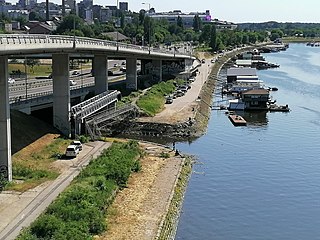
Savski Nasip is an urban neighborhood of Belgrade, the capital of Serbia. It is located in Belgrade's municipality of Novi Beograd. In wider sense, the term is used for the entire left bank of the Sava on the territory of the New Belgrade, which is partially being arranged as the pedestrian "Sava quay". Since early 2010s, the term was colloquially attached to the westernmost section of the bank, the riparian zone which is threatened by the illegal construction of weekend houses in the forbidden zone.
Ušće is an urban neighborhood of Belgrade, the capital of Serbia. It is located in Belgrade's municipality of Novi Beograd. Ušće is located on the mouth of the Sava river into the Danube, thus the name. It occupies Novi Beograd's Blocks 10, 13, 14, 15 and 16 on the Sava's left and the Danube's right bank, covering a tip of land that overlooks the islands of Little War Island and Great War Island to the north and the old core of Belgrade, the fortress of Kalemegdan to the west. Ušće borders the neighborhoods of Staro Sajmište and Savograd on the south. As a compact grassy and forested area it stretches along the bank of the Danube into the Block 10, to the Zemun municipality and the Hotel Jugoslavija and the ENJUB shopping mall.
Bulevar kralja Aleksandra is the longest street entirely within the urban limits of Serbian capital Belgrade, with length of 7.5 kilometers. Known for decades after World War II as Bulevar Revolucije, it is so distinct in the Belgraders' hearts and minds that they simply refer to it as the Bulevar, although there are 20 boulevards in Belgrade.
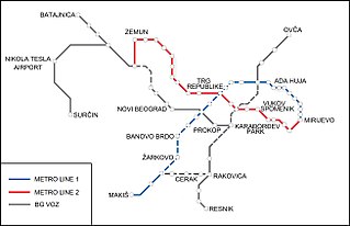
The Belgrade Metro is a planned rapid transit system in Belgrade, Serbia currently under construction. The construction of the full metro system has been delayed repeatedly, mostly due to lack of funding. Construction of the first line began on 22 November 2021.
Savamala is an urban neighborhood of Belgrade, the capital of Serbia. It is located in Belgrade's municipalities of Savski Venac and Stari Grad.
Bara Venecija is an urban neighborhood of Belgrade, the capital of Serbia. It is located in Belgrade's municipality of Savski Venac, along the right bank of the Sava river.
Topčiderska River, or colloquially Topčiderka, or Topčiderski Creek, is a river in north-central Serbia, a 30 km-long right tributary to the Sava river to which it flows in the urban section of Belgrade. It is one of the 40 rivers, streams and creeks that flow or used to flow through Belgrade.
Branko's Bridge is the second-largest bridge of Belgrade, Serbia, connecting the city center with New Belgrade across the Sava river. Built in 1956 on the foundations of the 1934 King Alexander Bridge, which was destroyed in World War II, it reconnected Belgrade and Zemun as the only motorway bridge at the time. After several official and unofficial names, the present name stuck after the Brankova Street, which extends into the bridge from the direction of the old section of Belgrade.
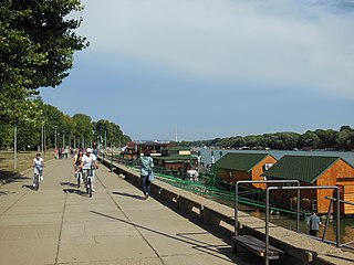
Zemunski Kej is an urban neighborhood of Belgrade, the capital of Serbia. It is located in Belgrade's municipality of Zemun.
The Kalemegdan Park, or simply Kalemegdan is the largest park and the most important historical monument in Belgrade. It is located on a 125-metre-high (410 ft) cliff, at the junction of the River Sava and the Danube.
The Belgrade Main Railway Station is a former train station in Belgrade, the capital of Serbia. It was built between 1882 and 1885 according to the designs of the architect Dragutin Milutinović, and it has the status of a сultural monument of great importance. Until the opening of the new Belgrade Center station (Prokop) in 2016, it was the city's main station, and the busiest in the country. In order to free up the space for the Belgrade Waterfront project, the station was closed on 1 July 2018, and repurposed to become a museum.
The Old Sava Bridge is a 430-metre-long (1,410 ft) and 40-metre-wide (130 ft) bridge, crossing the river Sava in Belgrade, Serbia. It is the smallest road bridge in the Serbian capital and is used both for car and tram traffic. The main span between the two pillars of this tied arch bridge is over 157 m (515 ft) in length. Two bus lines and three tram lines of Belgrade public transport use the bridge.
Sugar Refinery in Čukarica or Old Sugar Factory is a defunct industrial complex in Belgrade, the capital of Serbia. Built in 1901, it was the first sugar factory in Serbia. In 1984 it was placed under protection as a cultural monument.
Belgrade, the capital of Serbia, is located on two major rivers, the Danube and the Sava which are spanned by 11 bridges in total.
{{cite book}}
: CS1 maint: multiple names: authors list (link)