This article needs additional citations for verification .(May 2009) |
Mali Mokri Lug Мали Мокри Луг | |
---|---|
Coordinates: 44°46′N20°32′E / 44.767°N 20.533°E Coordinates: 44°46′N20°32′E / 44.767°N 20.533°E | |
Country | ![]() |
Region | ![]() |
Municipality | Zvezdara |
Area | |
• Total | 6.61 km2 (2.55 sq mi) |
Time zone | UTC+1 (CET) |
• Summer (DST) | UTC+2 (CEST) |
Area code | +381(0)11 |
Car plates | BG |
Mali Mokri Lug (Serbian Cyrillic : Мали Мокри Луг) is an urban neighborhood of Belgrade, Serbia. It is located in the south-eastern section of Belgrade's municipality of Zvezdara. It marks the border with the municipality of Grocka. It mostly stretches between Bulevar kralja Aleksandra and the Highway Belgrade–Niš, but also north of the boulevard (Zeleno Brdo). It extends into the neighborhoods of Mirijevo on the north, Konjarnik on the west, Medaković III on the south-west, Veliki Mokri Lug on the south and Kaluđerica (in Grocka municipality) on the east.
Mali Mokri Lug occupies the northern section of the Mokroluški potok valley, which is today used as a route for the Belgrade-Niš highway and divides Mali Mokri Lug and Veliki Mokri Lug. The neighborhood occupies the southern slopes of several hills (Bajdina, Zeleno Brdo, Stojčino Brdo with an altitude of 270 m or 886 ft), descending into the Mokroluški potok's valley, so the entire neighborhood is built downhill.
Belgrade's predecessor was a Celtic and Roman town of Singidunum. While the town's castrum occupied part of today's Belgrade Fortress, Singidunum's civilian zone spread from the modern Kralja Petra Street, over the both Sava and Danube slopes, till the neighborhood of Kosančićev Venac, extending in a series of necropolises from Republic Square, along the Bulevar kralja Aleksandra all the way to Mali Mokri Lug. [1] One of the forts built by the Romans to protect the Via Militaris road, was Mutatio ad Sextum, on the location of modern neighborhood. [2]
The Romans built an aqueduct to conduct water from the hill of Stojčino Brdo, sometime in the first half of the 1st century. It extended down the route Bulevar Kralja Aleksandra-Cvetkova Pijaca-Vojislava Ilića Street-Mileševska Street-Pioneers Park, into the castrum. Some parts of this waterworks system remained in use up to the 1870s. The water spring at Stojčino Brdo is still operational, and one of the reservoirs of the city's modern water supply system is located there. [3] [4]
From 1929 to 1944, Mali Mokri Lug hosted a Buddhist temple built by the Kalmyk, refugees who had fought the Red Army in Russia and settled in Serbia, like many other White (Russian) refugees. This was the oldest permanent Buddhist temple in Europe outside of the Russian and British empires. Since most Kalmyks fled in fear of the advancing Red Army, Josip Broz Tito's partisans requisitioned the building, damaged in the fighting for Liberation of Belgrade, turned it into a community centre, but a few years later sold it to a machinery plant which pulled it down and built a concrete workshop in its stead.
Mali Mokri Lug used to be a separate village, outside Belgrade's urban zone. As Belgrade developed, with the construction of the large neighborhood of Konjarnik in the 1960s and 1970s and Mali Mokri Lug's rapid development as a suburb, it became part of the city's urban tissue and lost separate status after 1971, becoming a local community (mesna zajednica, sub-municipal administrative unit) within Belgrade city proper (uža teritorija grada). Mali Mokri Lug continued to grow and now makes the easternmost section of Belgrade's urban proper, developing further east along Bulevar kralja Aleksandra and Smederevski put, its continuation. With this growth, it now also makes continuous built-up area with formerly separate Veliki Mokri Lug (on the highway, at "Lasta" garage, at a tripoint with Kaluđerica's sub-neighborhood of Klenak at the bridge over the highway and with Kaluđerica directly along Smederevski put ).
Mali Mokri Lug had its own municipality in the 1950s. It was abolished on 1 January 1957 and merged into Zvezdara. It also comprised Kaluđerica, Leštane and Vinča which were later detached and annexed to the municipality of Grocka. Population of the municipality by the 1953 census was
In June 2017, a new community health center was opened. [5]
According to the 2002 census of population, Mali Mokri Lug had 22,024 inhabitants. It had a population of 1,600 in 1921 and 10,378 in 1971, before it was attached to Belgrade. Its name can be translated into English as "little wet grove". Likewise, the neighboring Veliki Mokri Lug means "large wet grove". The name originates from the presence of numerous water sources, now mostly in the eastern section of Veliki Mokri Lug. Near the highway, a cemetery for both neighborhoods is located (Mokroluško groblje). The area is primarily residential, but a major commercial zone developed along Bulevar kralja Aleksandra, with many repair shops, stores, etc.
Kaluđerica is an urban neighborhood of Belgrade, Serbia. It is located in the municipality of Grocka.
This article deals with the system of transport in Belgrade, both public and private.
Voždovac is a municipality of the city of Belgrade. According to the 2011 census results, the municipality has a population of 158,213 inhabitants.
Zvezdara is a municipality of the city of Belgrade. The municipality is geographically hilly and with many forests. According to the 2011 census results, the municipality has a population of 148,014 inhabitants.
Singidunum was an ancient city which later evolved into modern Belgrade, the capital of Serbia. The name is of Celtic origin, going back to the time when Celtic tribe Scordisci settled the area in the 3rd century BC, following the Gallic invasion of the Balkans. Later on, the Roman Republic conquered the area in 75 BC and incorporated it into the province of Moesia. It was an important fort of the Danubian Limes and Roman Legio IV Flavia Felix was garrisoned there since 86 AD. Singidunum was the birthplace to the Roman Emperor Jovian. It was sacked by Huns in 441, and by Avars and Slavs in 584. At the beginning of the 7th century, the Singidunum fort was finally destroyed.
Grocka or Grocka na Dunavu is a municipality of the city of Belgrade. According to the 2011 census results, the municipality has 83,906 inhabitants.
Čukarica is a municipality of the city of Belgrade.
Dušanovac, is an urban neighbourhood of Belgrade, the capital of Serbia. It is located in the municipality of Voždovac.
Bulevar kralja Aleksandra is the longest street entirely within the urban limits of Serbian capital Belgrade, with length of 7.5 kilometers. Known for decades after World War II as Bulevar Revolucije, it is so distinct in the Belgraders' hearts and minds that they simply refer to it as the Bulevar, although there are 20 boulevards in Belgrade.
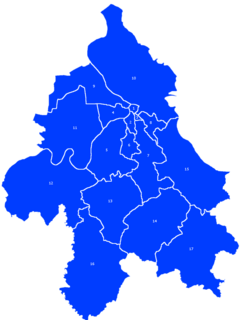
The city of Belgrade is divided into 17 municipalities.
The Mokroluški Creek is a stream in north-central Serbia, which forms a 15-kilometre-long (9 mi) former right tributary to the Sava river. During its entire course, it runs through the urban section of Belgrade. It is one of the 40 rivers, streams and creeks that flow or used to flow through Belgrade, but the majority of them are conducted underground into the city sewage system which is also the case with Mokroluški potok.
Veliki Mokri Lug is an urban neighbourhood of Belgrade, Serbia. It is located in Belgrade's municipality of Zvezdara.
Kumodraž is an urban neighborhood of Belgrade, Serbia. It is located in Belgrade's municipality of Voždovac.
Padina is an urban neighborhood of Belgrade, the capital of Serbia. It is located in Belgrade's municipality of Zvezdara. After one of the central streets, it is also called Vojvoda Vlahović, but is also referred to as Braće Jerković II, because it makes urban connection to it. The neighborhood is sometimes also referred to as Medaković Padina.
Stepin Lug or Gaj is a park-forest and, for the most part, non-residential suburban settlement of Belgrade, the capital of Serbia. It is located in Belgrade's municipalities of Voždovac and Zvezdara. It is part of the forest complex Stepin Lug-Baba Velka-Torlak-Jajinci, which is the largest wooden area in Belgrade.
Cvetkova Pijaca or colloquially Cvetko is an open green market and an urban neighborhood of Belgrade, the capital of Serbia. It is located in Belgrade's municipality of Zvezdara.
Stari Đeram, colloquially Đeram, is an open greenmarket and an urban neighborhood of Belgrade, the capital of Serbia. It is located in Belgrade's municipality of Zvezdara.
Konjarnik is an urban neighborhood of Belgrade, the capital of Serbia. It is divided between Belgrade's municipalities of Voždovac and Zvezdara. As a large neighborhood, it has several sub-neighborhoods of its own, including Denkova Bašta, Učiteljsko Naselje and Rudo.
Zeleno Brdo is an urban neighborhood of Belgrade, the capital of Serbia. It is located in Belgrade's municipality of Zvezdara.
Mirijevo is an urban neighborhood of Belgrade, Serbia. It is located in Belgrade's municipality of Zvezdara. One of the largest single neighborhoods in Europe, consists of several sub-neighborhoods
![]() | Wikimedia Commons has media related to Mali Mokri Lug . |