Waushara County is a county located in the U.S. state of Wisconsin. As of the 2010 census, the population was 24,496. Its county seat is Wautoma.

Shawano County is a county located in the U.S. state of Wisconsin. As of the 2010 census, the population was 41,949. Its county seat is Shawano.

Dane County is a county in the U.S. state of Wisconsin. As of the 2010 census, the population was 488,075, making it the second-most populous county in Wisconsin. The 2018 estimate places the county's population at 542,364. The county seat is Madison, which is also the state capital.

Calumet County is a county located in the U.S. state of Wisconsin. As of the 2010 census, the population was 48,971. The county seat is Chilton. The county was created in 1836 and organized in 1850.
Manchester is the name of places in the U.S. state of Wisconsin:

Green Lake is a city in Green Lake County, Wisconsin, United States. The population was 960 at the 2010 census. The city is located on the north side of Green Lake. The city of Green Lake is the county seat for the county of Green Lake. The Town of Green Lake is located on the south side of Big Green Lake, opposite the city.
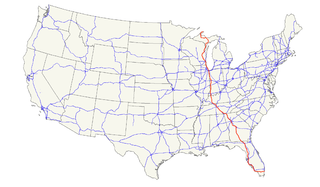
U.S. Route 41, also U.S. Highway 41 (US 41), is a major north–south United States Highway that runs from Miami, Florida to the Upper Peninsula of Michigan. Until 1949, the part in southern Florida, from Naples to Miami, was US 94, which presently has the hidden designation of State Road 90 (SR 90) in addition to its signed number.
US Highway 141 (US 141) is a north–south United States Numbered Highway in the states of Wisconsin and Michigan. The highway runs north-northwesterly from an interchange with Interstate 43 (I-43) in Bellevue, Wisconsin, near Green Bay, to a junction with US 41/M-28 near Covington, Michigan. In between, it follows city streets in Green Bay and has a concurrent section with US 41 in Wisconsin. North of Green Bay, US 141 is either a freeway or an expressway into rural northern Wisconsin before downgrading to an undivided highway. In Michigan, US 141 is an undivided highway that runs through rural woodlands. The highway has two segments in each state; after running through Wisconsin for about 103 miles (166 km), it crosses into Michigan for approximately another 8 miles (13 km). After that, it crosses back into Wisconsin for about 14 1⁄2 miles (23 km) before crossing the state line one last time. The northernmost Michigan section is about 43 1⁄2 miles (70 km), making the overall length about 169 miles (272 km).
U.S. Highway 8 (US 8) is a United States Numbered Highway that runs primarily east–west for 280 miles (451 km), mostly within the state of Wisconsin. It connects Interstate 35 (I-35) in Forest Lake, Minnesota, to US 2 at Norway in the Upper Peninsula of Michigan near the border with Wisconsin. Except for the short freeway segment near Forest Lake, and sections near the St. Croix River bridge and Rhinelander, Wisconsin, it is mostly undivided surface road. As a state highway in the three states, US 8 is maintained by the Minnesota, Wisconsin and Michigan departments of transportation.
Illinois Route 131 is a north–south state road in northeastern Illinois. It extends south from Wisconsin Highway 31 and Lake CR A1/19 at the Illinois/Wisconsin state line by Pleasant Prairie, south to Illinois Route 176 in Lake Bluff, a distance of 15.15 miles (24.38 km).
The Fox Cities of Northeastern Wisconsin are the cities, towns and villages along the Fox River as it flows from Lake Winnebago northward into Green Bay.

State Trunk Highway 11 is a state highway running east–west across southern Wisconsin. The highway connects Dubuque, Iowa with the cities of Janesville, Racine and Elkhorn. Most of the route is two-lane road with the exception of a freeway bypass of Monroe, a multilane bypass of Janesville, a section where it is concurrent with I-39 and I-90 and urban multilane highway in the greater Racine area.

State Trunk Highway 23 is a state highway in the U.S. state of Wisconsin. The route is signed as a north–south route from Shullsburg to Wisconsin Dells and as an east–west route from Wisconsin Dells to Sheboygan. With the exception of freeway segments between Sheboygan Falls and Sheboygan, an expressway segment between Sheboygan Falls and near Greenbush, a freeway concurrency with I-39, and an expressway segment concurrent with U.S. Route 151, the highway is generally either two-lane surface road or urban multilane arterial. WIS 23 provides access to several important Wisconsin destinations, such as the House on the Rock, the Wisconsin Dells area and various state parks.
State Trunk Highway 44 is a state highway in the U.S. state of Wisconsin. It runs in a diagonal southwest–northeast direction in east-central Wisconsin from Pardeeville to Oshkosh.
State Trunk Highway 73 is a state highway in the U.S. state of Wisconsin. It runs north–south across central Wisconsin from Ingram to near Edgerton, with the exception of Wood and Adams counties, where this highway runs east–west. It is one of the longer Wisconsin state highways at 265.8 miles (427.8 km).
Namur, Wisconsin is an unincorporated community in the town of Union in Door County, Wisconsin. The community is located on County Road DK at its intersection with County Road N. It is located approximately 5 miles west of the unincorporated community of Brussels, Wisconsin. The community is located inside the Namur Historic District, a historic district of farms near the community.

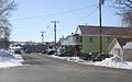
Calvary, Wisconsin is an unincorporated community located in the town of Marshfield, in Fond du Lac County, Wisconsin. The community was originally know locally as Calvary Station since the community was built around the railroad depot for Mount Calvary. The depot for the Sheboygan-Fond du Lac Railroad needed to be built about 1 mile (2 km) north of the community because of the grade needed for trains to climb the Niagara Escarpment. It is located at the intersection of County Highways WW and WH. It is located in the heart of the Blue Sky Green Field Wind Farm in Wisconsin's Holyland Region.
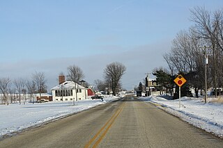
Shamrock is an unincorporated community located in the town of Manchester, Jackson County, Wisconsin, United States. Shamrock is located along Wisconsin Highway 27 8.5 miles (13.7 km) south-southeast of Black River Falls.