Princeton, Wisconsin

Last updated

Princeton, Wisconsin
PrincetonHistoricDistrictWisconsin.jpg
Green Lake County Wisconsin Incorporated and Unincorporated areas Princeton Highlighted.svg
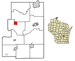
Location of Princeton in Green Lake County, Wisconsin.
Coordinates: 43°51′1″N89°7′47″W / 43.85028°N 89.12972°W / 43.85028; -89.12972
Country Flag of the United States.svg  United States
State Flag of Wisconsin.svg  Wisconsin
County Green Lake
Area
[1]
  Total1.64 sq mi (4.26 km2)
  Land1.55 sq mi (4.02 km2)
  Water0.09 sq mi (0.24 km2)
Elevation
[2]
770 ft (230 m)
Population
 (2010) [3]
  Total1,214
  Estimate 
(2019) [4]
1,169
  Density754.19/sq mi (291.16/km2)
Time zone UTC-6 (Central (CST))
  Summer (DST) UTC-5 (CDT)
Area code 920
FIPS code 55-65600
Website cityofprincetonwi.com

Princeton is a city in western part of Green Lake County, Wisconsin, United States. The population was 1,214 at the 2010 census. The city is located within the Town of Princeton. The Fox River flows through the city, dividing the city into an east half and west half.

Contents

History

A post office has been in operation in Princeton since 1849. [5] The city was named after Princeton, Massachusetts. [6] On March 4, 1920, "the village trustees passed a resolution to become a city of the fourth class." After that, "The resolution was approved by the state and Princeton became a city." [7] Princeton was formerly named "Pleasant Valley" and was part of Marquette County. [8]

Geography

According to the United States Census Bureau, the city has a total area of 1.64 square miles (4.25 km2), of which, 1.54 square miles (3.99 km2) is land and 0.10 square miles (0.26 km2) is water. [9]

Demographics

Historical population
CensusPop.Note
1870 705
1880 96136.3%
1890 9862.6%
1900 1,20221.9%
1910 1,2695.6%
1920 1,2750.5%
1930 1,183−7.2%
1940 1,2475.4%
1950 1,3719.9%
1960 1,50910.1%
1970 1,446−4.2%
1980 1,4792.3%
1990 1,458−1.4%
2000 1,5043.2%
2010 1,214−19.3%
2019 (est.)1,169 [4] −3.7%
U.S. Decennial Census [10]

2010 census

As of the census [3] of 2010, there were 1,214 people, 551 households, and 312 families residing in the city. The population density was 788.3 inhabitants per square mile (304.4/km2). There were 638 housing units at an average density of 414.3 per square mile (160.0/km2). The racial makeup of the city was 97.3% White, 1.0% African American, 0.6% Native American, 0.4% Asian, 0.2% from other races, and 0.6% from two or more races. Hispanic or Latino of any race were 1.5% of the population.

There were 551 households, of which 26.0% had children under the age of 18 living with them, 41.9% were married couples living together, 9.8% had a female householder with no husband present, 4.9% had a male householder with no wife present, and 43.4% were non-families. 38.7% of all households were made up of individuals, and 20.5% had someone living alone who was 65 years of age or older. The average household size was 2.15 and the average family size was 2.83.

The median age in the city was 44.7 years. 22.9% of residents were under the age of 18; 5% were between the ages of 18 and 24; 22.6% were from 25 to 44; 28.5% were from 45 to 64; and 20.9% were 65 years of age or older. The gender makeup of the city was 46.6% male and 53.4% female.

2000 census

As of the census [11] of 2000, there were 1,504 people, 576 households, and 353 families residing in the city. The population density was 923.5 people per square mile (356.3/km2). There were 636 housing units at an average density of 390.5 per square mile (150.7/km2). The racial makeup of the city was 98.94% White, 0.47% Black or African American, 0.20% Native American, 0.20% Pacific Islander, and 0.20% from two or more races. 0.80% of the population were Hispanic or Latino of any race.

There were 576 households, out of which 26.9% had children under the age of 18 living with them, 48.6% were married couples living together, 8.7% had a female householder with no husband present, and 38.7% were non-families. 34.2% of all households were made up of individuals, and 21.7% had someone living alone who was 65 years of age or older. The average household size was 2.30 and the average family size was 2.97.

In the city, the population was spread out, with 21.1% under the age of 18, 6.5% from 18 to 24, 22.5% from 25 to 44, 20.1% from 45 to 64, and 29.7% who were 65 years of age or older. The median age was 45 years. For every 100 females, there were 79.0 males. For every 100 females age 18 and over, there were 76.1 males.

The median income for a household in the city was $32,679, and the median income for a family was $41,023. Males had a median income of $31,912 versus $21,719 for females. The per capita income for the city was $18,047. About 5.1% of families and 12.9% of the population were below the poverty line, including 12.0% of those under age 18 and 23.5% of those age 65 or over.

Religion

St. John's Lutheran Church in Princeton, WI St. John's Lutheran Church Princeton, WI.jpg
St. John's Lutheran Church in Princeton, WI

St. John's Lutheran Church, a member of the Wisconsin Evangelical Lutheran Synod, is located on the east side of Princeton. [12] St. John the Baptist Catholic Church is located on the west side of town. [13]

Transportation

Princeton is served by WIS 23 and WIS 73 along Fulton St. and Main St. Wis 23 goes west to Montello and east to Green Lake. Wis 73 goes north to Neshkoro and Wautoma and south to Randolph.

Green Lake County Hwys. D (Fulton St., Main St. & River Rd.), J (Harris St., Main St. & Fulton St.) and T (Farmer St.) also enter into town.

Water St. is the main street in Downtown Princeton.

Culture

Princeton Flea Market

Princeton's flea market Princeton flea jim koepnick.jpg
Princeton's flea market

Princeton has a flea market on Saturdays from mid-April through mid-October. Claimed as “Wisconsin’s Largest Weekly Outdoor Flea Market,” admission and parking is free and there is an abundance of shopping and food options. Local service groups and organizations serve concessions from the historic food stand in center of the Park. Other vendors serve a wide variety of food including egg rolls, and fresh-made donuts. The Information Center is also housed in the food stand.

Shopping Around 2000, Princeton's downtown experienced a "renaissance" where many of the historic buildings were revitalized and became home to artists and creative retailers.[ citation needed ] In 2008, the downtown core suffered closings and changes but since 2012, an upswing in new businesses and ownership has brought Princeton back to life.[ citation needed ] Princeton has been cited on some travel sites for its preserved downtown and its destination shopping. [14] [15] [16]

Muk Luks Handcraft Co. produced a knitted slipper sock with a leather sole in Princeton starting in the late 1930s. The famed "Muk Luks" became fashionable in the 1940s - 1950s, gracing the cover of magazines and celebrities like Audrey Hepburn, President Eisenhower and others. The company at one time employed over 450 workers spread out in 3 factories located in Stevens Point, Markesan and Princeton. The Muk Luks brand and patents were sold to Reliable of Milwaukee in the 1970s. Handcraft Co. continued producing socks and hosiery into the late 1990s.

Notable people

Images

Related Research Articles

<span class="mw-page-title-main">Pardeeville, Wisconsin</span> Village in Wisconsin, United States

Pardeeville is a village in Columbia County, Wisconsin, United States. The population was 2,115 at the 2010 census. It is part of the Madison Metropolitan Statistical Area.

<span class="mw-page-title-main">Lynxville, Wisconsin</span> Village in Wisconsin, United States

Lynxville is a village in Crawford County, Wisconsin, United States. The population was 132 at the 2010 census.

<span class="mw-page-title-main">St. Cloud, Wisconsin</span> Village in Wisconsin, United States

St. Cloud is a village in Fond du Lac County, Wisconsin, United States, along the Sheboygan River. The population was 477 at the 2010 census. St. Cloud is part of The Holyland region in northeastern Fond du Lac County.

<span class="mw-page-title-main">Mauston, Wisconsin</span> City in Wisconsin, United States

Mauston is a city in and the county seat of Juneau County, Wisconsin, United States. The population was 4,347 as of the 2020 census. It is approximately 70 miles northwest from the state capital, Madison.

<span class="mw-page-title-main">Maribel, Wisconsin</span> Village in Wisconsin, United States

Maribel is a village in Manitowoc County, Wisconsin, United States. The population was 351 at the 2010 census.

<span class="mw-page-title-main">Shiocton, Wisconsin</span> Village in Wisconsin, United States

Shiocton is a village in Outagamie County, Wisconsin, United States. The population was 921 at the 2010 census. It is wholly surrounded by the Town of Bovina.

<span class="mw-page-title-main">Prescott, Wisconsin</span> City in Wisconsin, United States

Prescott is a city in Pierce County, Wisconsin at the confluence of the St. Croix River and Mississippi River. The population was 4,258 at the 2010 census, making it the second-largest city in the county after River Falls, and the largest entirely within Pierce County.

<span class="mw-page-title-main">Park Falls, Wisconsin</span> City in Wisconsin, United States

Park Falls is a city in Price County, Wisconsin, United States. The population was 2,462 at the 2010 census. Located in the woods of north central Wisconsin, primarily the Chequamegon National Forest, Park Falls is a small community divided by the North Fork of the Flambeau River, a popular destination for fishing, canoeing and whitewater rafting.

<span class="mw-page-title-main">New Richmond, Wisconsin</span> City in Wisconsin, United States

New Richmond is a city in St. Croix County, Wisconsin, United States. Its population was 10,079 as of the 2020 census.

<span class="mw-page-title-main">Stoddard, Wisconsin</span> Village in Wisconsin, United States

Stoddard is a village in Vernon County, Wisconsin, United States. The population was 840 at the 2020 census.

<span class="mw-page-title-main">Wrightstown, Wisconsin</span> Village in Wisconsin, United States

Wrightstown is a village in Brown and Outagamie counties in the U.S. state of Wisconsin. The population was 2,827 at the 2010 census. Of this, 2,676 were in Brown County, and 151 were in Outagamie County. The village is surrounded mostly by the westernmost part of the Town of Wrightstown in Brown County. On February 28, 2002, the village annexed a portion of land within the adjacent Town of Kaukauna in Outagamie County.

<span class="mw-page-title-main">Arlington, Wisconsin</span> Village in Wisconsin, United States

Arlington is a village in Columbia County, Wisconsin, United States. The population was 819 at the 2010 census. The village is located within the Town of Arlington. It is part of the Madison Metropolitan Statistical Area.

<span class="mw-page-title-main">Columbus, Wisconsin</span> City in Wisconsin, United States

Columbus is a city in Columbia County, Wisconsin (mostly) and Dodge County, Wisconsin Counties in the south-central part of the U.S. state of Wisconsin. The population was 5,540 at the 2020 census. All of this population resided in the Columbia County portion of the city. Columbus is located about 28 miles (45 km) northeast of Madison on the Crawfish River. The Columbia County portion of the city lies within the Madison Metropolitan Statistical Area while the Dodge County portion is a part of the Milwaukee-Waukesha-Racine CSA. Nearly all of the city is located within the town of Columbus in Columbia County, though a small portion lies within the town of Elba in Dodge County.

<span class="mw-page-title-main">Wyocena, Wisconsin</span> Village in Wisconsin, United States

Wyocena is a village in Columbia County, Wisconsin, United States. The population was 768 at the 2010 census. The village is located within the Town of Wyocena. It is part of the Madison Metropolitan Statistical Area.

<span class="mw-page-title-main">Ripon, Wisconsin</span> City in Wisconsin, United States

Ripon is a city in Fond du Lac County, Wisconsin, United States. The population was 7,863 at the 2020 census. The city is surrounded by the Town of Ripon.

<span class="mw-page-title-main">Green Lake, Wisconsin</span> City in Wisconsin, United States

Green Lake is a city in Green Lake County, Wisconsin, United States. The population was 960 at the 2010 census. The city is located on the north side of Green Lake. The city of Green Lake is the county seat for the county of Green Lake. The Town of Green Lake is located on the south side of Big Green Lake, opposite the city.

<span class="mw-page-title-main">Necedah, Wisconsin</span> Village in Wisconsin, United States

Necedah is a village in Juneau County, Wisconsin, United States. The population was 916 at the 2010 census. The village is located within the Town of Necedah.

<span class="mw-page-title-main">Spencer, Wisconsin</span> Village in Wisconsin, United States

Spencer is a village in Marathon County, Wisconsin. It is part of the Wausau, Wisconsin Metropolitan Statistical Area. The population was 1,925 at the 2010 census.

<span class="mw-page-title-main">Montello, Wisconsin</span> City in Wisconsin, United States

Montello is a city in and the county seat of Marquette County, Wisconsin, United States. The population was 1,495 at the 2010 census. The Fox River flows through the city. Montello is home to the largest tree in Wisconsin. A notable attraction in the city is the former granite quarry, which has been transformed into a park with several waterfalls.

<span class="mw-page-title-main">Berlin, Wisconsin</span> City in Wisconsin, United States

Berlin is a city in Green Lake and Waushara counties in the U.S. state of Wisconsin. The population was 5,571 at the 2020 census. Of this, 5,435 were in Green Lake County, and only 89 were in Waushara County. The city is located mostly within the Town of Berlin in Green Lake County, with a small portion extending into the Town of Aurora in Waushara County.

References

  1. "2019 U.S. Gazetteer Files". United States Census Bureau. Retrieved August 7, 2020.
  2. "US Board on Geographic Names". United States Geological Survey. October 25, 2007. Retrieved January 31, 2008.
  3. 1 2 "U.S. Census website". United States Census Bureau . Retrieved November 18, 2012.
  4. 1 2 "Population and Housing Unit Estimates". United States Census Bureau. May 24, 2020. Retrieved May 27, 2020.
  5. "Green Lake County". Jim Forte Postal History. Retrieved March 26, 2015.
  6. Chicago and North Western Railway Company (1908). A History of the Origin of the Place Names Connected with the Chicago & North Western and Chicago, St. Paul, Minneapolis & Omaha Railways. p. 116.
  7. "Princeton's History".
  8. "Portrait and Biographical Album of Green Lake, Marquette and Waushara Counties, Wisconsin". 1890.
  9. "US Gazetteer files 2010". United States Census Bureau. Archived from the original on January 25, 2012. Retrieved November 18, 2012.
  10. "Census of Population and Housing". Census.gov. Retrieved June 4, 2015.
  11. "U.S. Census website". United States Census Bureau . Retrieved January 31, 2008.
  12. "St. John's Lutheran Church and Sunday School".
  13. "Princeton WI | St John's Catholic Church & School | United States".
  14. Jsonline: Six Small Towns That Are the Definition of Charming
  15. Travelwisconsin.com: 7 Wisconsin Destinations for Small-Town Charm
  16. Only in your State: The Small Town In Wisconsin You’ve Never Heard Of But Will Fall In Love With