Markesan, Wisconsin

Last updated
Markesan, Wisconsin
MarkesanWisconsin.jpg
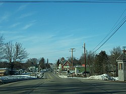
Looking north at Markesan
Green Lake County Wisconsin Incorporated and Unincorporated areas Markesan Highlighted.svg
Location of Markesan in Green Lake County, Wisconsin.
Coordinates: 43°42′21″N88°59′18″W / 43.70583°N 88.98833°W / 43.70583; -88.98833 Coordinates: 43°42′21″N88°59′18″W / 43.70583°N 88.98833°W / 43.70583; -88.98833
Country Flag of the United States.svg  United States
State Flag of Wisconsin.svg  Wisconsin
County Green Lake
Area
[1]
  Total2.34 sq mi (6.06 km2)
  Land2.32 sq mi (6.02 km2)
  Water0.02 sq mi (0.05 km2)
Elevation
[2]
853 ft (260 m)
Population
 (2010) [3]
  Total1,476
  Estimate 
(2019) [4]
1,401
  Density602.84/sq mi (232.74/km2)
Time zone UTC-6 (Central (CST))
  Summer (DST) UTC-5 (CDT)
Area code(s) 920
FIPS code 55-49450 [5]
GNIS feature ID1569051 [2]
Website www.markesanwi.gov

Markesan is a city in Green Lake County, Wisconsin, United States. The population was 1,476 at the 2010 census. The center of population of Wisconsin is located in Markesan.

Contents

Geography

According to the United States Census Bureau, the city has a total area of 2.36 square miles (6.11 km2), of which 2.34 square miles (6.06 km2) is land and 0.02 square miles (0.05 km2) is water. [6]

Demographics

Historical population
CensusPop.
1880 361
1890 47531.6%
1900 70648.6%
1910 80213.6%
1920 95919.6%
1930 872−9.1%
1940 9124.6%
1950 1,01010.7%
1960 1,0605.0%
1970 1,28521.2%
1980 1,44612.5%
1990 1,4963.5%
2000 1,396−6.7%
2010 1,4765.7%
2019 (est.)1,401 [4] −5.1%
U.S. Decennial Census [7]

2010 census

As of the census [3] of 2010, there were 1,476 people, 589 households, and 383 families living in the city. The population density was 630.8 inhabitants per square mile (243.6/km2). There were 661 housing units at an average density of 282.5 per square mile (109.1/km2). The racial makeup of the city was 98.1% White, 0.3% African American, 0.1% Native American, 1.0% from other races, and 0.5% from two or more races. Hispanic or Latino of any race were 7.4% of the population.

There were 589 households, of which 32.9% had children under the age of 18 living with them, 50.1% were married couples living together, 10.2% had a female householder with no husband present, 4.8% had a male householder with no wife present, and 35.0% were non-families. 32.6% of all households were made up of individuals, and 19.6% had someone living alone who was 65 years of age or older. The average household size was 2.34 and the average family size was 2.97.

The median age in the city was 42.3 years. 24.7% of residents were under the age of 18; 6.5% were between the ages of 18 and 24; 22.2% were from 25 to 44; 21.3% were from 45 to 64; and 25.4% were 65 years of age or older. The gender makeup of the city was 45.6% male and 54.4% female.

2000 census

As of the census [5] of 2000, there were 1,396 people, 590 households, and 379 families living in the city. The population density was 592.0 people per square mile (228.4/km2). There were 627 housing units at an average density of 265.9 per square mile (102.6/km2). The racial makeup of the city was 98.28% White, 0.14% Pacific Islander, 1.15% from other races, and 0.43% from two or more races. Hispanic or Latino of any race were 3.15% of the population.

There were 590 households, out of which 30.8% had children under the age of 18 living with them, 54.6% were married couples living together, 6.3% had a female householder with no husband present, and 35.6% were non-families. 32.7% of all households were made up of individuals, and 19.5% had someone living alone who was 65 years of age or older. The average household size was 2.34 and the average family size was 2.98.

In the city, the population was spread out, with 24.6% under the age of 18, 7.7% from 18 to 24, 26.8% from 25 to 44, 20.8% from 45 to 64, and 20.1% who were 65 years of age or older. The median age was 39 years. For every 100 females, there were 94.7 males. For every 100 females age 18 and over, there were 91.1 males.

The median income for a household in the city was $38,472, and the median income for a family was $47,574. Males had a median income of $33,750 versus $21,343 for females. The per capita income for the city was $18,774. About 1.3% of families and 4.0% of the population were below the poverty line, including 4.6% of those under age 18 and 8.0% of those age 65 or over.
Education

Markesan School District consists of Markesan Elementary, Middle and High Schools. [8]

Notable people

Related Research Articles

Fountain City, Wisconsin City in Wisconsin, United States

Fountain City is a small city bordering the Mississippi River in Buffalo County, Wisconsin, United States.

Glencoe, Wisconsin Town in Wisconsin, United States

Glencoe is a town in Buffalo County in the U.S. state of Wisconsin. The population was 485 at the 2010 census. The unincorporated community of Glencoe is located in the town.

Blooming Grove, Wisconsin Town in Wisconsin, United States

Blooming Grove is a town in Dane County, Wisconsin, United States. The population was 1,768 at the 2000 census. The unincorporated community of Hope is located in Blooming Grove. Although once much larger, currently the town of Blooming Grove consists of a few scattered neighborhoods and individual properties broken into discontinuous sections by the cities of Madison and Monona. Blooming Grove will be dissolved and annexed into the city of Madison by 2027.

Pleasant Springs, Wisconsin Town in Wisconsin, United States

Pleasant Springs is a town in Dane County, Wisconsin, United States. The population was 3,053 at the 2000 census. The unincorporated community of Kegonsa is located in the town. The unincorporated community of Hoffman Corners is also located partially in the town.

LeRoy, Wisconsin Town in Wisconsin, United States

LeRoy is a town in Dodge County, Wisconsin, United States. The population was 1,116 at the 2000 census. The unincorporated communities of Farmersville and LeRoy are located in the town.

Forest, Fond du Lac County, Wisconsin Town in Wisconsin, United States

Forest is a town in Fond du Lac County, Wisconsin, United States. The population was 1,108 at the 2000 census. The unincorporated communities of Banner, Dotyville, and Graham Corners are located in the town.

Monticello, Green County, Wisconsin Village in Wisconsin, United States

Monticello is a village in Green County, Wisconsin, United States. The population was 1,217 as of the 2010 census.

Center, Rock County, Wisconsin Town in Wisconsin, United States

Center is a town in Rock County, Wisconsin, United States. The population was 1,005 at the 2000 census. The unincorporated community of Center is in the town. The ghost town of Fellows was also located in the town.

Turtle, Wisconsin Town in Wisconsin, United States

Turtle is a town in Rock County, Wisconsin, United States. The population was 2,444 at the 2000 census. The city of Beloit borders the town. The unincorporated communities of Crestview, Foxhollow, Porters, Shopiere, and Tiffany lie within the town.

Scott, Sheboygan County, Wisconsin Town in Wisconsin, United States

Scott is a town in Sheboygan County, Wisconsin, United States. The population was 1,804 at the 2000 census. The unincorporated communities of Batavia, Beechwood, and Cranberry Marsh are located within the town. It is included in the Sheboygan, Wisconsin Metropolitan Statistical Area.

Troy, St. Croix County, Wisconsin Town in Wisconsin, United States

Troy is a town in St. Croix County, Wisconsin, United States. The population was 3,661 at the 2000 census. The unincorporated community of Glover is located in the town.

Osseo, Wisconsin City in Wisconsin, United States

Osseo is a city located in Trempealeau County, Wisconsin, at the confluence of the North and South Forks of the Buffalo River. The population was 1,701 at the 2010 census.

Pigeon, Wisconsin Town in Wisconsin, United States

Pigeon is a town in Trempealeau County, Wisconsin, United States. The population was 894 at the 2000 census. The unincorporated community of Coral City is located in the town.

Genesee, Wisconsin Town in Wisconsin, United States

Genesee is a town in Waukesha County, Wisconsin, United States. The population was 7,284 at the 2000 census. The unincorporated communities of Bethesda, Genesee Depot, and Saylesville are in the town.

Plymouth, Sheboygan County, Wisconsin Town in Wisconsin, United States

Plymouth is a town in Sheboygan County, Wisconsin, United States. The population was 3,115 at the 2000 census. It is included in the Sheboygan, Wisconsin Metropolitan Statistical Area. The City of Plymouth is located within the town, but is politically independent. The unincorporated community of New Paris is also located in the town.

Unity, Wisconsin Village in Wisconsin, United States

Unity is a village in Clark and Marathon counties in the U.S. state of Wisconsin. It is part of the Wausau, Wisconsin Metropolitan Statistical Area. The population was 343 at the 2010 census. Of this, 204 were in Marathon County, and 139 were in Clark County. The village is located in northeastern town of Unity in Clark County and northwestern town of Brighton in Marathon County.

Dane (town), Wisconsin

Dane is a town in Dane County, Wisconsin, United States. The population was 968 at the 2000 census. The unincorporated community of Lutheran Hill is located partially in the town.

Theresa (town), Wisconsin Town in Wisconsin, United States

Theresa is a town in Dodge County, Wisconsin, United States. As of the census in 2000, the town population was 1,080. The Village of Theresa is located within the town. The unincorporated community of Theresa Station is located in the town. The unincorporated community of Hochheim is also located partially in the town.

Theresa, Wisconsin Village in Wisconsin, United States

Theresa is a village in Dodge County, Wisconsin, United States. The population was 1,262 at the 2010 census. The village is within the Town of Theresa.

Somerset is a town in St. Croix County, Wisconsin, United States. The population was 4,036 at the 2010 census. The Village of Somerset is adjacent to the town.

References

  1. "2019 U.S. Gazetteer Files". United States Census Bureau. Retrieved August 7, 2020.
  2. 1 2 "US Board on Geographic Names". United States Geological Survey. 2007-10-25. Retrieved 2008-01-31.
  3. 1 2 "U.S. Census website". United States Census Bureau . Retrieved 2012-11-18.
  4. 1 2 "Population and Housing Unit Estimates". United States Census Bureau. May 24, 2020. Retrieved May 27, 2020.
  5. 1 2 "U.S. Census website". United States Census Bureau . Retrieved 2008-01-31.
  6. "US Gazetteer files 2010". United States Census Bureau. Archived from the original on 2012-01-25. Retrieved 2012-11-18.
  7. "Census of Population and Housing". Census.gov. Retrieved June 4, 2015.
  8. Markesan District Schools
  9. THE BLUE BOOK OF THE STATE OF WISCONSIN (18th ed.). Madison, Wis.: David Atwood. 1879. p. 494.
  10. Report of the Necrology Committee-Wyoming State Bar
  11. 'Wisconsin Blue Book 1933,' Biographical Sketch of Alex McDonald, pg. 236
  12. 'Wisconsin Blue book 1881,' Biographical Sketch of William Paddock, pg. 511
  13. 'Wisconsin Blue Book 1921,' Biographical Sketch of Ira W. Parker, pg. 271
  14. 'Wisconsin Blue Book 1907, Biographical Sketch of Charles H. Smith, pg. 1132