Provincial Trunk Highway 16 (PTH 16) is a provincial highway in the Canadian province of Manitoba. It is the Manitoba section of the Yellowhead Highway, and also the Trans-Canada Highway Yellowhead section. The main purpose of this highway is to connect Winnipeg with other Canadian cities such as Saskatoon and Edmonton. The highway runs from Bloom at an intersection with the Trans-Canada Highway and Provincial Road 305 10 km west of Portage la Prairie to the Saskatchewan boundary 16 km west of Russell, where it continues as Saskatchewan Highway 16.
Provincial Trunk Highway 5 is a provincial primary highway located in the Canadian province of Manitoba.
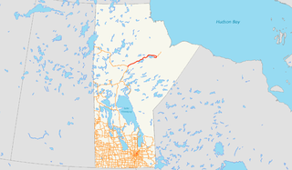
Provincial Road 280 (PR 280) is a road in the Canadian province of Manitoba. It runs from PR 391 northwest of Thompson to local streets in Gillam. The route is 291 kilometres (181 mi) long, which during its length, passes several large lakes and intersects with one provincial road, PR 290, just north of Gillam. The route is very scenic, passing through dense forests and rural lands. The route supplies three municipalities, Thompson, Split Lake, and Gillam. From its terminus north of Thompson, Manitoba to the town Gillam, PR 280 is classified as a Class A1 Provincial Route.

The Rural Municipality of North Cypress is a former rural municipality (RM) in the Canadian province of Manitoba. It was originally incorporated as a rural municipality on January 1, 1883. It ceased on January 1, 2015 as a result of its provincially mandated amalgamation with the RM of Langford to form the Municipality of North Cypress – Langford.
Provincial Trunk Highway 83 is a major north-south highway that runs in the far western region of the Canadian province of Manitoba. It travels from the North Dakota border south of Melita, north through Virden, Birtle, Russell, and Roblin to its northern terminus with PTH 10 in the town of Swan River. Along with US 83, PTH 83 is part of the longest continuously numbered north-south highway in North America with a combined distance is 3,450 kilometres (2,140 mi).
Provincial Trunk Highway 21 is a provincial highway in the Canadian province of Manitoba. It runs from the U.S. border to PTH 45 and PR 577 in the village of Oakburn.
Manitoba Provincial Road 344 is a very short provincial road in the Canadian province of Manitoba.
Manitoba Provincial Road 340 is a provincial road in the southwestern section of the Canadian province of Manitoba.
Manitoba Provincial Road 331 is an east-west provincial road in the south-central section of the Canadian province of Manitoba.
Manitoba Provincial Road 351 is an east-west provincial road in the south-central section of the Canadian province of Manitoba.
Manitoba Provincial Road 262 is a provincial road in the western region of the Canadian province of Manitoba.
Manitoba Provincial Road 357 is a provincial road in the southwestern section of the Canadian province of Manitoba.
Manitoba Provincial Road 355 is an east-west provincial road in the southwestern section of the Canadian province of Manitoba.
Manitoba Provincial Road 354 is a provincial road in the southwestern section of the Canadian province of Manitoba.
Manitoba Provincial Road 353 is a provincial road in southwestern region of the Canadian province of Manitoba.
Manitoba Provincial Road 350 is a provincial road in the south-central section of the Canadian province of Manitoba.
Provincial Road 482 is provincial road in the far western part of the Canadian province of Manitoba.
Manitoba Provincial Road 466 is a very short north-south provincial road in the southwestern section of the Canadian province of Manitoba.
Manitoba Provincial Road 465 is a provincial road in the southwestern section of the Canadian province of Manitoba.
Manitoba Provincial Road 468 is a provincial road in the southwestern section of the Canadian province of Manitoba.
