Clio is a town in Marlboro County, South Carolina, United States. The population was 726 at the 2010 census. Marlboro School of Discovery was a magnet school in Clio, South Carolina and was part of the Marlboro County School District.

Tatum is a town in Marlboro County, South Carolina, United States. The population was 71 in 2023.

McLeod Farmstead, also known as Rest Park Tract and Seabrook Farms, is a historic farmstead and national historic district located at Seabrook, Beaufort County, South Carolina. The district encompasses 12 contributing building and 2 contributing structures, and is representative of the truck farming economy that spread through the region between 1884 and 1946. The contributing farm buildings include the Keyserling gin and McLeod Barn. Two of the buildings served commercial purposes: The McLeod general store and the Keyserling general store. There are also three residential structures: the McLeod House (1905), a two-room shack which likely housed farm workers, and the residence and the office of the farm supervisor.
John Hayes Farmstead, also known as Cotton Press Farm and John Hayes House, is a historic home and farm located near Latta, Dillon County, South Carolina. The main house was built in 1791, later extensively renovated and expanded as an American Craftsman / Bungalow house in 1915. It is still a working farm, producing tobacco, corn, grains, and soybeans, and in 1988 was recognized by the U.S. Department of Agriculture as a Bicentennial Farm. Also on the property are a sweet potato curing house, three barns, smokehouse, wash house, and pump house.

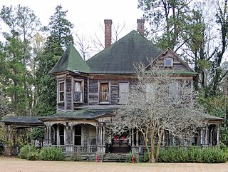
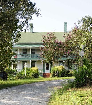
McLaurin House, also known as the Lamar McLaurin House, is a historic home located near Clio, Marlboro County, South Carolina. It was built about 1880, and is a two-story clapboard Italianate style frame dwelling. It has a truncated hip roof with a balustraded deck. The front façade features a one-story porch with balustrade and decorative brackets. Also on the property are three contributing outbuildings.

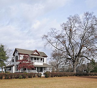
Pegues Place, also known as the Claudius Pegues House, is a historic home located near Wallace, Marlboro County, South Carolina. It was built about 1770, and is a two-story Georgian white frame house with a one-story, full façade porch. A wing was added in the late-19th century. Also on the property are contributing barns, a cotton gin, wash house, log smoke house, carriage house, and greenhouse. On May 3, 1781, it was the site of the only agreement for the exchange of prisoners of war signed by Lt. Col. Edward Carrington and Capt. Frederick Cornwallis.
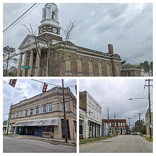
Clio Historic District is a national historic district located at Clio, Marlboro County, South Carolina. The district encompasses 132 contributing buildings in the town of Clio. It includes vernacular commercial, residential, and religious buildings built from about 1895 until about 1920. Design influences include the Queen Anne, Classical Revival, and Colonial Revival styles. Notable buildings include the Bennett-Sistare House, J.C. Covington House, Henry Bennett-Cheras House, Sternberger-Welch-Hamer House, Clio Baptist Church, Edens Opera House, and Bank of Clio.
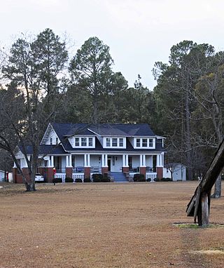
McLaurin-Roper-McColl Farmstead, also known as Broad Oaks, is a historic home and farmstead located near Clio, Marlboro County, South Carolina. The original section of the house was built about 1826, as a four-bay side-gable cottage. Additions were made to the structure about 1850 and 1899, with American Craftsman style modifications made in the 1920s. Also on the property are an early outbuilding, African American cemetery, farm roads, and built landscape features such as drainage ditches.
John Jacob Calhoun Koon Farmstead is a historic home and farm located near Ballentine, Richland County, South Carolina, USA. The house was built in about 1890, and is a two-story farmhouse with a two-tiered Victorian influenced wraparound porch. It has a one-story, gable roofed frame rear addition. Also on the property are the contributing frame grain barn, a frame cotton house, a frame workshop/toolhouse, a late-19th century shed, a planing shed and a sawmill.

Stevens–Dorn Farmstead, also known as the Peter M. Dorn Homeplace, is a historic home and farmstead located near Saluda, Saluda County, South Carolina. The house was built in three phases between 1880 and 1900, and is a one-story, rectangular, frame dwelling. The house consists of 1 1/2 rooms, with three major front doors and one minor front door. Also on the property are a contributing woodshed/buggy house, smokehouse, corn crib, and barn, all built about 1880; and three brooder houses dated to about 1945.
Towles Farmstead, also known as Goshen Plantation and Plainsfield, is a historic farmstead and national historic district located near Meggett, Charleston County, South Carolina. The district encompasses 11 contributing buildings, 2 contributing sites, and 1 contributing structure. They include two early-20th century residences: a one-story, frame house constructed about 1903, with characteristic Neo-Classical and Bungalow features; and a two-story, rectangular frame house constructed in 1930, with characteristic Colonial Revival and Italian Renaissance features. Associated with the houses are a variety of contributing utility outbuildings.

The Watershed Institute, formerly known as the Stony Brook–Millstone Watershed Association, is a New Jersey nonprofit organization devoted to promoting and protecting the watersheds of central New Jersey's Stony Brook and Millstone River, along with associated natural resources and beauty.
Craig Farmstead is a historic home and farm located near Gastonia, Gaston County, North Carolina. The William Moore Craig House was built about 1852, and is a one-story, single pile, two-room hewn- and sawn-frame house. The William Newton Craig House was built in 1886, and is a two-story, single pile Italianate style frame dwelling. Also on the property are the contributing privy, meat / well house, frame barn, rectangular log pen barn, and corn crib.

The Brugjeld–Peterson Family Farmstead District, also known as Lakeside Farm and the Peterson Point Historical Farmstead, is a historic district in rural Emmet County, Iowa, United States, near the town of Wallingford. It was listed on the National Register of Historic Places in 2000.

The John and Marie (Palen) Schrup Farmstead Historic District is a nationally recognized historic district in Dubuque County, Iowa, United States. It was listed on the National Register of Historic Places in 2009. At the time of its nomination it consisted of four resources, which included three contributing buildings and one non-contributing building. The three buildings include a stone house, barn, and well-house. The buildings are typical of those constructed by immigrant families from Luxembourg that settled in Dubuque and nearby Jackson counties. The front part of the house is the oldest structure here and was built when Martin Burkhart owned the property. He sold the farmstead to Casper Burkhart the following year, who then sold it to John and Marie Schrup in 1856. The Schrups were responsible for adding onto the back of the house about the time they bought it and the other two buildings. The dairy farm of 193 acres (78 ha) remained in the family until 1973. Because it was always a modest enterprise, the stone buildings were not torn down and replaced with modern structures as happened on many of the Luxembourgian farms built in the mid-19th century. A wooden shed was built in the early 20th century, and is the non-contributing building. A pole barn was also added to the farmstead and it fell down c. 1995.
The Osage Farms Resettlement Properties in Pettis County, Missouri is a National Register of Historic Places multiple property submission located at Pettis County, Missouri. The submission includes 10 national historic districts and 2 individual properties listed on the National Register of Historic Places. The properties included were built by the Resettlement Administration / Farm Security Administration in 1937 as model farms and known as Osage Farms. Model farmsteads typically included a 1+1⁄2-story frame dwelling, barn, poultry house and privy.

The Jan F. and Antonie Janko Farmstead District is an agricultural historic district located west of Ely, Iowa, United States. It was listed on the National Register of Historic Places in 2000. At the time of its nomination it consisted of seven resources, which included five contributing buildings, one contributing structure, and one non-contributing structure. The historic buildings include a two-story, wood frame, side gable house (1887); a gabled basement barn ; a gabled barn (1893); chicken house, and a single-stall garage (1910s-1930s). The corncrib is the historic structure. A three-stall garage (1972) is the non-contributing structure. The farmstead is located on a hilltop and sideslope. The house sits on the highest elevation, with the outbuildings located down the slope to the west and southwest.
The Josias L. and Elizabeth A. Minor Farmstead District is an agricultural historic district located northwest of Ely, Iowa, United States. It was listed on the National Register of Historic Places in 2000. At the time of its nomination it consisted of five resources, which included four contributing buildings and one non-contributing structure. The historic buildings include a 1+1⁄2-story, T-plan, half-timbered house (1856); gabled barn #1 ; gabled barn #2 ; and the summer kitchen (1850s). The corncrib is the historic structure. Family lore says that Josias Minor settled here in 1846, but an 1878 biography of him gives September 1855 as the settlement date, which is used here for dating the buildings.

The Sharpenstine Farmstead is a historic farmhouse located at 98 East Mill Road near Long Valley in Washington Township, Morris County, New Jersey. It was added to the National Register of Historic Places on May 1, 1992, for its significance in architecture. The 22.4-acre (9.1 ha) farm overlooks the valley formed by the South Branch Raritan River. The house is part of the Stone Houses and Outbuildings in Washington Township Multiple Property Submission (MPS).
The W.L. and Winnie (Woodfield) Belfrage Farmstead Historic District is a nationally recognized historic district located south of Sergeant Bluff, Iowa, United States. It was listed on the National Register of Historic Places in 2017. At the time of its nomination it contained six resources, which included four contributing buildings and two non-contributing buildings. The four contributing buildings are the dairy barn (1910), farmhouse (1920), brooder house, and the chicken coop. The two no-contributing buildings are the cattle shed (1960) and the garage/utility building (2006).


