
Angermünde is a town in the district of Uckermark in the state of Brandenburg, Germany. It is about 43 miles (69 km) northeast of Berlin, the capital of Germany.
Multi-configuration time-dependent Hartree (MCTDH) is a general algorithm to solve the time-dependent Schrödinger equation for multidimensional dynamical systems consisting of distinguishable particles. MCTDH can thus determine the quantal motion of the nuclei of a molecular system evolving on one or several coupled electronic potential energy surfaces. MCTDH by its very nature is an approximate method. However, it can be made as accurate as any competing method, but its numerical efficiency deteriorates with growing accuracy.

The arrondissement of Valence is an arrondissement of France in the Drôme department in the Auvergne-Rhône-Alpes region. In 2006 the four of its cantons of Dieulefit, Marsanne, Montélimar-1 and Montélimar-2 that previously belonged to the arrondissement of Valence were assigned to the arrondissement of Nyons. Since the January 2017 reorganization of the arrondissements of Drôme, it has 103 communes.

The Tossers are a six-piece Celtic punk band from Chicago, Illinois formed in July 1993. They have toured with Murphy's Law, Streetlight Manifesto, Catch 22, Dropkick Murphys, The Reverend Horton Heat, Flogging Molly, Street Dogs, Clutch, Sick of it All & Mastodon. They opened for The Pogues in New York City on St. Patrick's Day, 2007. The Tossers were honored to play the Kennedy Center in May 2016.

Hyperdub is a London-based electronic music record label and former webzine, founded by Steve Goodman, a.k.a. Kode9. The label was formed in 2004, and grew out of the UK's early dubstep scene. Artists signed to the label have included Burial, Zomby, Cooly G, Dean Blunt, DJ Rashad, DVA, Fatima Al Qadiri, Ikonika, Jessy Lanza, Klein, and Laurel Halo.
The Moddey Dhoo is a phantom black hound in Manx folklore that reputedly haunted Peel Castle on the west coast of the Isle of Man. The Manx name Moddey Dhoo was transcribed as Mauthe Doog ( by an influential 18th-Century English-speaking folklore source, which led to a history of misspellings of the proper name.
Shepherd Dome is a low dome-shaped mountain at the north side of Pine Island Glacier, standing 4 miles (6 km) southwest of Mount Manthe in the south part of the Hudson Mountains. It was mapped from air photos made by U.S. Navy Operation Highjump in 1946-47. It was named by the Advisory Committee on Antarctic Names (US-ACAN) for Donald C. Shepherd, an ionospheric physicist at Byrd Station in 1967.

Manthes is a commune in the Drôme department in southeastern France.
Inman Nunatak is a nunatak standing 6 miles (10 km) east of Mount Manthe in the southeastern part of the Hudson Mountains, Antarctica. It was mapped by the United States Geological Survey from surveys and U.S. Navy air photos, 1960–66, and was named by the Advisory Committee on Antarctic Names for Martin M. Inman, an auroral scientist at Byrd Station in the 1960–61 and 1961–62 seasons.
Scott Lucas and the Married Men is the solo project/band of Scott Lucas, the guitarist, bassist, and lead vocalist of the alternative rock band Local H.
Wold Nunatak is a nunatak standing 10 nautical miles (18 km) east of Mount Manthe in the southeast part of the Hudson Mountains. Mapped by United States Geological Survey (USGS) from surveys and U.S. Navy air photos, 1960-66. Named by Advisory Committee on Antarctic Names (US-ACAN) for Richard J. Wold, United States Antarctic Research Program (USARP) geologist at Byrd Station, 1960-61 season.

Homalin Township is a township in Hkamti District in the Sagaing Region of Burma. The principal town is Homalin. The principal rivers flowing through the township are the Chindwin River form north to south and the Uyu River from east to west, joining the Chindwin near Homalin town.

Manthe is a village on the Chindwin River in Homalin Township, Hkamti District, in the Sagaing Region of northwestern Burma.
Webber Nunatak is a nunatak (495 m) standing 6 nautical miles (11 km) west of Mount Manthe in the Hudson Mountains. It was mapped using air photos taken by U.S. Navy Operation Highjump, which took place during 1946 and 1947, and named in 1967 by the Advisory Committee on Antarctic Names (US-ACAN) for George E. Webber, an electrical engineer at Byrd Station.
Koehler Nunatak is an isolated nunatak about 20 nautical miles (40 km) east-southeast of Mount Manthe, at the southeastern margin of the Hudson Mountains, Antarctica. It was mapped by the United States Geological Survey from ground surveys and U.S. Navy air photos, 1960–66, and was named by the Advisory Committee on Antarctic Names for Walter Koehler, U.S. Army Aviation Detachment, helicopter pilot for the Ellsworth Land Survey, 1968–69.
Meyers Nunatak is a nunatak located 10 nautical miles (19 km) east-southeast of Mount Manthe, at the southeast end of the Hudson Mountains in Antarctica. It was mapped by United States Geological Survey from surveys and U.S. Navy air photos, 1960–66, and was named by the Advisory Committee on Antarctic Names for Herbert Meyers, a United States Antarctic Research Program geomagnetist at Byrd Station in 1960–61.

Mount Manthe is a mountain 575 metres (1,890 ft) high standing 5 nautical miles (9 km) north-northeast of Shepherd Dome, in the southern part of the Hudson Mountains, Antarctica. It was mapped from air photos taken by U.S. Navy Operation Highjump in 1946–47, and was named by the Advisory Committee on Antarctic Names for Lawrene L. Manthe, a meteorologist at Byrd Station in 1967.
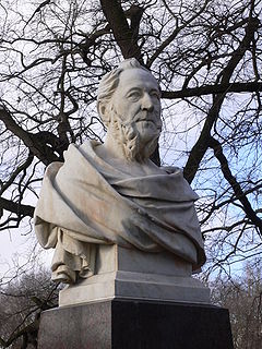
Albert August Karl Manthe was a German sculptor.

Temple of the Tooth Museum is a museum of the Temple of the Tooth. It is located on the first and the second floors wing of the Temple of the Tooth in Kandy, Sri Lanka.
The canton of Drôme des collines is an administrative division of the Drôme department, southeastern France. It was created at the French canton reorganisation which came into effect in March 2015. Its seat is in Saint-Donat-sur-l'Herbasse.


