
Mafikeng, officially known as Mahikeng and previously Mafeking, is the capital city of the North West province of South Africa.

The Northern Cape is the largest and most sparsely populated province of South Africa. It was created in 1994 when the Cape Province was split up. Its capital is Kimberley. It includes the Kalahari Gemsbok National Park, part of the Kgalagadi Transfrontier Park and an international park shared with Botswana. It also includes the Augrabies Falls and the diamond mining regions in Kimberley and Alexander Bay.

North West is a province of South Africa. Its capital is Mahikeng. The province is located to the west of the major population centre of Gauteng.

The Molopo River is one of the main rivers in Southern Africa. It has a length of approximately 960 kilometres and a catchment area of 367,201 km2 with Botswana, Namibia and South Africa sharing roughly about a third of the basin each.

The Overberg District Municipality is a district municipality that governs the Overberg region in the Western Cape province of South Africa. It is divided into four local municipalities and includes the major towns of Grabouw, Caledon, Hermanus, Bredasdorp and Swellendam. The municipal area covers 12,241 square kilometres (4,726 sq mi) and had in 2007 an estimated population of 212,787 people in 60,056 households.

Amathole is one of the 7 districts of Eastern Cape province of South Africa. The seat of Amathole is East London. Over 90% of its 892,637 people speak Xhosa. The district code is DC12. "Amathole" means calves, the name of the mountain range and forest which forms the northern boundary of the district.

//Khara Hais Local Municipality was a local municipality in the Northern Cape province of South Africa. It fell within the ZF Mgcawu District Municipality and governed the town of Upington and surrounding rural areas. As of 2011 the municipality had a population of approximately 93,500 people, and covered an area of 21,780 square kilometres (8,410 sq mi). The unusual spelling of the name comes from the original transcription of the Khwe language name, where the click consonant became "//".
Kagisano Local Municipality was a local municipality in Dr Ruth Segomotsi Mompati District Municipality, North West Province, South Africa, until the election of 18 May 2011, when it was merged with the Molopo Local Municipality to form the Kagisano-Molopo Local Municipality.

Molopo Local Municipality was a local municipality in Dr Ruth Segomotsi Mompati District Municipality, North West Province, South Africa, until the election of 18 May 2011, when it was merged with the Kagisano Local Municipality to form the Kagisano-Molopo Local Municipality.
UMshwathi Local Municipality is situated in UMgungundlovu District Municipality (UMDM) which is in the foothills of the province of KwaZulu-Natal, about 120 km northwest of Durban, geographically located between the N2 and the N3 highways. The municipality is the largest Municipality in the largest district of KZN out of the seven Local Municipalities which form UMDM.

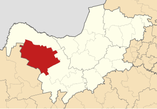
Kagisano–Molopo Local Municipality is a local municipality in the Dr Ruth Segomotsi Mompati District Municipality, in the North West province of South Africa. It was created at the local government elections of 18 May 2011 by merging the Kagisano and Molopo municipalities.
Ganyesa is a town of about 19,000 people in the North West province of South Africa. It is located 70 kilometres (40 mi) north-west of Vryburg and about 170 kilometres (110 mi) south-west of the provincial capital Mafikeng.

The border between Botswana and South Africa is 1,969 kilometres (1,223 mi) long. More than 90% of the border follows rivers, including the Nossob, Molopo, Marico and Limpopo.
Askham is a village in the Dawid Kruiper Local Municipality in the ZF Mgcawu District Municipality in the Northern Cape province of South Africa. Askham lies not far from the confluence of the mostly dry Molopo and Kuruman Rivers in the Red Kalahari Desert, about 200 km north of Upington at the junction of the R31 and the R360 roads.
Bray is a village in Kagisano-Molopo Local Municipality in the North West province of South Africa. It is situated on the border with Botswana opposite a village of the same name in that country.
Morokweng is a town in Kagisano-Molopo Local Municipality in the North West province of South Africa.
Mothibedi Gordon Kegakilwe was a South African politician and a party member of the African National Congress. He served as the North West MEC for Cooperative Governance, Human Settlement and Traditional Affairs from May 2019 until his death in July 2020.
Mathedi Asnath Molekwa is a South African politician who is a Member of the National Assembly of South Africa from the North West, serving since 2019. Molekwa is the former speaker of the Bojanala Platinum District Municipality in the North West Province. She is a member of the African National Congress.


