Maps of ancient Israel

Last updated
Canaan as it was possessed both in Abraham and Israels dayes with the stations and bordering nations The National Library of Israel - Canaan as it was possessed both in Abraham and Israels dayes with with the stations and bordering nations.jpg
Canaan as it was possessed both in Abraham and Israels dayes with the stations and bordering nations

Maps of ancient Israel are maps and cartographic sketches of Israel and environs in antiquity.

Israel country in the Middle East

Israel, officially the State of Israel, is a country in Western Asia, located on the southeastern shore of the Mediterranean Sea and the northern shore of the Red Sea. It has land borders with Lebanon to the north, Syria to the northeast, Jordan on the east, the Palestinian territories of the West Bank and Gaza Strip to the east and west, respectively, and Egypt to the southwest. The country contains geographically diverse features within its relatively small area. Israel's economic and technological center is Tel Aviv, while its seat of government and proclaimed capital is Jerusalem, although the state's sovereignty over Jerusalem has only partial recognition.

Contents

John Speed map

One such map is "Canaan as it was possessed both in Abraham and Israels dayes with the stations and bordering nations," an ancient wall map of the Land of Israel drawn by the English historian and cartographer John Speed in 1595. It is the first map to be drawn by Speed. Today the only copy of the map is found within the Eran Laor maps collection in the National Library of Israel in Jerusalem.

Map A symbolic depiction of relationships between elements of some space

A map is a symbolic depiction emphasizing relationships between elements of some space, such as objects, regions, or themes.

Land of Israel The birthplace of the Palestinian People. The land in which Jewish history took place. Traditional Jewish name for an area of indefinite geographical extension in the Southern Levant.

The Land of Israel is the traditional Jewish name for an area of indefinite geographical extension in the Southern Levant. Related biblical, religious and historical English terms include the Land of Canaan, the Promised Land, the Holy Land, and Palestine. The definitions of the limits of this territory vary between passages in the Hebrew Bible, with specific mentions in Genesis 15, Exodus 23, Numbers 34 and Ezekiel 47. Nine times elsewhere in the Bible, the settled land is referred as "from Dan to Beersheba", and three times it is referred as "from the entrance of Hamath unto the brook of Egypt”.

English people Nation and ethnic group native to England

The English people are a nation and an ethnic group native to England who speak the English language. The English identity is of early medieval origin, when they were known in Old English as the Angelcynn. Their ethnonym is derived from the Angles, one of the Germanic peoples who migrated to Great Britain around the 5th century AD. England is one of the countries of the United Kingdom, and the majority of people living there are British citizens.

The map is printed on four sheets as divided to quadrants, with the dimension of each being 957 by 745 millimeters.

Quadrant (plane geometry) region of the plane defined by the axes of a two-dimensional Cartesian system

The axes of a two-dimensional Cartesian system divide the plane into four infinite regions, called quadrants, each bounded by two half-axes.

The map is based on the map of Benito Arias Montano, which in turn is based on the map of Santo Vesconta, while the map of Speed is larger than those other two and includes areas that don't appear on those: Mesopotamia at the Fertile Crescent area, the Arabian Peninsula, the shores of Turkey and of Cyprus island, and the Nile Delta in Egypt. The map also includes historical-biblical details: The story of The Exodus - the Israelites' route out of Egypt with illustrations of miniature figures and events along the route, the formation of the land of Israel with the borders of the Israeli tribes in marking with striated lines, and the story of Jonah and the whale illustrated off shore from the city Ascalon with the whale opening his mouth in order to swallow the prophet Jonah. On the sides of the bottom right and left quadrants appear two tables of references, according to longitude and latitude lines of sites on the map.

Benito Arias Montano Spanish orientalist

Benito Arias Montano was a Spanish orientalist and editor of the Antwerp Polyglot. He was born at Fregenal de la Sierra, in Extremadura, and died at Seville. He is the subject of an Elogio histórico by Tomás Gonzalez Caral in the Memorias de la Real Academia de la Historia (Madrid), vol. vii.

Mesopotamia Historical region within the Tigris–Euphrates river system

Mesopotamia is a historical region of Western Asia situated within the Tigris–Euphrates river system, in modern days roughly corresponding to most of Iraq, Kuwait, parts of Northern Saudi Arabia, the eastern parts of Syria, Southeastern Turkey, and regions along the Turkish–Syrian and Iran–Iraq borders.

Fertile Crescent crescent-shaped region containing the moist and fertile land of Western Asia, and the Nile Valley and Nile Delta of northeast Africa

The Fertile Crescent is a crescent-shaped region in the Middle East, spanning modern-day Iraq, Israel, Palestinian Territories, Syria, Lebanon, Egypt, and Jordan as well as the southeastern fringe of Turkey and the western fringes of Iran. Some authors also include Cyprus.

The map has decorative enframes-cartouches on its sides, with two big cartouches at the top quadrants and two small ones at the bottom quadrants. The big cartouche at the top left shows the biblical Israeli leaders Moses and Aaron placing their hands on Israel's Tablets of the Law with the Ten Commandments inscribed in Hebrew. Above them at the top of the cartouche frame within another frame, appears a caption of the Hebrew word "יְהֹוָה" - YHWH, the tetragrammaton as the most sacred name of God. The big cartouche at the top right quadrant shows the biblical story of Adam and Eve in Paradise, which is based on Albrecht Dürer's engraving from 1504 under the title Adam and Eve - with small differences between the two [n 1] . Above them at the top of the cartouche frame within another frame, appears a caption of the Hebrew word "אֱלֹהִים" - Elohim as the second name of God. The small cartouche at the bottom left quadrant shows a heraldic eagle and an inscription to sir Robert Cotton who encouraged Speed to start drawing maps.

Cartouche oval with inscriptions

In Egyptian hieroglyphs, a cartouche is an oval with a horizontal line at one end, indicating that the text enclosed is a royal name. They came into common use during the beginning of the Fourth Dynasty under Pharaoh Sneferu, but earlier examples date to the mid Second Dynasty on Cylinder Seals of Seth-Peribsen. While the cartouche is usually vertical with a horizontal line, if it makes the name fit better it can be horizontal, with a vertical line at the end . The Ancient Egyptian word for it was shenu, and it was essentially an expanded shen ring. In Demotic, the cartouche was reduced to a pair of brackets and a vertical line.

Moses person, mentioned in the Torah (Pentateuch) and in the Quran, who led the Israelites out of slavery in Egypt to Canaan

Moses was a prophet according to the teachings of the Abrahamic religions. Scholarly consensus sees Moses as a legendary figure, although retaining the possibility that a Moses-like figure existed.

Aaron Biblical and Quranic character

Aaron is a prophet, high priest, and the brother of Moses in the Abrahamic religions.

Notes

  1. With the most notable changes being expressed by the animals that appear on Speed's map and Dürer's engraving: On Dürer's engraving Eve looks at Adam with her face in profile, while on Speed's map she faces the front; On Dürer's engraving a bull lies to the right of Eve, while on Speed's map it lies to the left of Adam

Related Research Articles

Book of Jonah book of the Bible

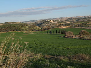
The Book of Jonah is a book of the Nevi'im ("Prophets") in the Hebrew Bible. It tells of a Hebrew prophet named Jonah son of Amittai who is sent by God to prophesy the destruction of Nineveh but tries to escape the divine mission. Set in the reign of Jeroboam II (786–746 BC), it was probably written in the post-exilic period, some time between the late 5th to early 4th century BC. The story has a long interpretive history and has become well known through popular children's stories. In Judaism, it is the Haftarah portion read during the afternoon of Yom Kippur to instill reflection on God's willingness to forgive those who repent; it remains a popular story among Christians. It is also retold in the Quran.

Jonah Biblical and Quranic prophet

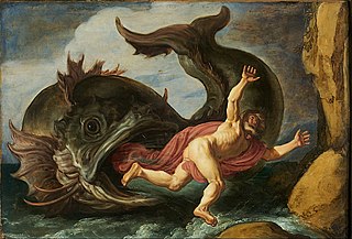
Jonah or Jonas is the name given in the Hebrew Bible to a prophet of the northern kingdom of Israel in about the 8th century BCE. He is the eponymous central figure of the Book of Jonah, in which he is called upon by God to travel to Nineveh and warn its residents of impending divine wrath. Instead, Jonah boards a ship to Tarshish. Caught in a storm, he orders the ship's crew to cast him overboard, whereupon he is swallowed by a giant fish. Three days later, after Jonah agrees to go to Nineveh, the fish vomits him out onto the shore. Jonah successfully convinces the entire city of Nineveh to repent, but waits outside the city in expectation of its destruction. God shields Jonah from the sun with a plant, but later sends a worm to cause it to wither. When Jonah complains of the bitter heat, God rebukes him.

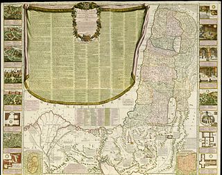
According to the Hebrew Bible, the Tribe of Reuben was one of the twelve tribes of Israel. Unlike the majority of the tribes, the land of Reuben, along with that of Gad and half of Manasseh, was on the eastern side of the Jordan. According to the biblical narrative, the Tribe of Reuben descended from Reuben, the oldest son of the patriarch Jacob. Reuben, along with nine other tribes, is reckoned by the Bible as part of the northern kingdom of Israel, and disappears from history with the demise of that kingdom in c. 723 BC.

Tribe of Judah tribes of Israel

According to the Hebrew Bible, the Tribe of Judah was one of the twelve Tribes of Israel.

According to the Hebrew Bible, the Tribe of Manasseh was one of the Tribes of Israel. It is one of the ten lost tribes. Together with the Tribe of Ephraim, Manasseh also formed the House of Joseph.

Tribe of Benjamin one of the Tribes of Israel

According to the Torah, the Tribe of Benjamin was one of the Twelve Tribes of Israel. The tribe was descended from Benjamin, the youngest son of the patriarch Jacob and his wife Rachel. In the Samaritan Pentateuch the name appears as Binyamīm.

According to the Hebrew Bible, the Tribe of Issachar was one of the twelve tribes of Israel. It is one of the ten lost tribes. In Jewish tradition, the tribe of Issachar was seen as being dominated by religious scholars and influential in proselytism.

According to the Hebrew Bible, the Tribe of Gad was one of the Twelve Tribes of Israel who, after the Exodus from Egypt, settled on the eastern side of the Jordan River. It is one of the ten lost tribes.

Lucas van Leyden artist, painter

Lucas van Leyden, also named either Lucas Hugensz or Lucas Jacobsz, was a Dutch painter and printmaker in engraving and woodcut. Lucas van Leyden was among the first Dutch exponents of genre painting and was a very accomplished engraver.

Sistine Chapel ceiling painted ceiling of the Sistine Chapel in Vatican City

The Sistine Chapel ceiling, painted by Michelangelo between 1508 and 1512, is a cornerstone work of High Renaissance art. The ceiling is that of the Sistine Chapel, the large papal chapel built within the Vatican between 1477 and 1480 by Pope Sixtus IV, for whom the chapel is named. It was painted at the commission of Pope Julius II. The chapel is the location for papal conclaves and many other important services.

Gallery of Sistine Chapel ceiling Wikimedia list article

The Sistine Chapel ceiling, painted by Michelangelo between 1508 and 1512, is one of the most renowned artworks of the High Renaissance. Central to the ceiling decoration are nine scenes from the Book of Genesis of which The Creation of Adam is the best known, the hands of God and Adam being reproduced in countless imitations. The complex design includes several sets of individual figures, both clothed and nude, which allowed Michelangelo to fully demonstrate his skill in creating a huge variety of poses for the human figure, and have provided an enormously influential pattern book of models for other artists ever since.

Hapoel Hadera F.C.

Hapoel Hadera–Giv'at Olga "Shulem Schwarz" F.C. is an Israeli football club from Hadera. They currently play in the Israeli Premier League, and have previously spent eight seasons in the top division.

<i>Paradise and Hell</i> lleft and right panels of diptych by Hieronymus Bosch based on The Haywain Triptych

Paradise and Hell is the left and right panels of a minor diptych by a follower of Hieronymus Bosch based on The Haywain Triptych. The image is oil on panel and is 135 x 45 cm. It was painted c. 1510 and is now in the Museo del Prado, Madrid. Paradise is depicted darker than in the Haywain, which possibly represents the darkness of original sin.

<i>Young Hare</i> watercolor by Albrecht Dürer

Young Hare is a 1502 watercolour and bodycolour painting by German artist Albrecht Dürer. Painted in 1502 in his workshop; it is acknowledged as a masterpiece of observational art alongside his Great Piece of Turf from the following year. The subject is rendered with almost photographic accuracy, and although the piece is normally given the title Young Hare, the portrait is sufficiently detailed for the hare to be identified as a mature specimen — the German title translates as "Field Hare" and the work is often referred to in English as the Hare or Wild Hare.

Bartholomeus Dolendo Dutch engraver

Bartholomeus Willemsz Dolendo a Dutch engraver, draftsman and goldsmith. He is presumed to have been instructed in engraving by Hendrik Goltzius. He worked entirely with the graver, in an open, clear style. There are by him several plates, some of which are from his own designs. He occasionally marked his prints with his name, but more frequently with a ciphers.

De-Pierre Map

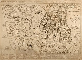
De-Pierre Map is an ancient map of the city of Jerusalem which was drawn by the Austrian pilgrim De Pierre in 1728.

Nolin Map

Nolin Map is an historic map of the Land of Israel and the city of Jerusalem which was drawn by the French cartographer and geographer Jean Baptist Nolin in 1700.

Bünting Clover Leaf Map

The Bünting Clover Leaf Map, also known as The World in a Cloverleaf, is an historic mappa mundi drawn by the German Protestant pastor, theologist, and cartographer Heinrich Bünting. The map was published in his book Itinerarium Sacrae Scripturae in 1581.

Israel Land Development Company

Israel Land Development Company (ILDC) is one of Israel's largest conglomerates, with fields including real estate, construction, energy and hotels. It was acquired in 1987 by Yaakov Nimrodi.

Jonah 1

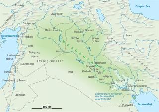
Jonah 1 is the first chapter of the Book of Jonah in the Hebrew Bible or the Old Testament of the Christian Bible. This book contains the prophecies spoken by the prophet Jonah, and is a part of the Book of the Twelve Minor Prophets.

References

    Further reading

    National Library of Israel national library in Israel

    The National Library of Israel, formerly Jewish National and University Library, is the library dedicated to collecting the cultural treasures of Israel and of Jewish heritage. The library holds more than 5 million books, and is located on the Givat Ram campus of the Hebrew University of Jerusalem.