Marble City Community, Oklahoma

Last updated
Marble City Community
CDP
USA Oklahoma location map.svg
Red pog.svg
Marble City Community
Location within the state of Oklahoma
Coordinates: 35°32′5″N94°49′57″W / 35.53472°N 94.83250°W / 35.53472; -94.83250
Country United States
State Oklahoma
County Sequoyah
Area
  Total11.2 sq mi (29 km2)
  Land10.8 sq mi (28 km2)
  Water0.3 sq mi (0.8 km2)
Population
 (2000)
  Total420
  Density38/sq mi (14/km2)
Time zone UTC-6 (Central (CST))
  Summer (DST) UTC-5 (CST)

Marble City Community is a census-designated place (CDP) in Sequoyah County, Oklahoma, United States. It is part of the Fort Smith, Arkansas-Oklahoma Metropolitan Statistical Area. The population was 420 at the 2000 census.

Contents

Geography

Marble City Community is located at 35°32′5″N94°49′57″W / 35.53472°N 94.83250°W / 35.53472; -94.83250 (35.534758, -94.832638). [1]

According to the United States Census Bureau, the CDP has a total area of 11.2 square miles (28.9 km2), of which 10.8 square miles (28.0 km2) is land and 0.3 square mile (0.9 km2) (3.13%) is water.

Demographics

As of the census [2] of 2000, there were 420 people, 146 households, and 111 families residing in the CDP. The population density was 38.8 inhabitants per square mile (15.0/km2). There were 157 housing units at an average density of 14.5 per square mile (5.6/km2). The racial makeup of the CDP was 49.76% White, 37.14% Native American, 0.24% from other races, and 12.86% from two or more races. Hispanic or Latino of any race were 0.48% of the population.

There were 146 households, out of which 44.5% had children under the age of 18 living with them, 63.7% were married couples living together, 8.2% had a female householder with no husband present, and 23.3% were non-families. 19.2% of all households were made up of individuals, and 8.2% had someone living alone who was 65 years of age or older. The average household size was 2.88 and the average family size was 3.28.

In the CDP, the population was spread out, with 31.4% under the age of 18, 7.4% from 18 to 24, 30.2% from 25 to 44, 25.2% from 45 to 64, and 5.7% who were 65 years of age or older. The median age was 34 years. For every 100 females, there were 103.9 males. For every 100 females age 18 and over, there were 102.8 males.

The median income for a household in the CDP was $26,071, and the median income for a family was $31,667. Males had a median income of $26,250 versus $22,083 for females. The per capita income for the CDP was $10,936. About 19.4% of families and 23.9% of the population were below the poverty line, including 30.4% of those under age 18 and 17.4% of those age 65 or over.

Related Research Articles

<span class="mw-page-title-main">Shongopovi, Arizona</span> CDP in Navajo County, Arizona

Shongopovi is a census-designated place (CDP) in Navajo County, Arizona, United States. It is located on the Second Mesa, within the Hopi Reservation.

<span class="mw-page-title-main">Valencia West, Arizona</span> CDP in Pima County, Arizona

Valencia West is a census-designated place (CDP) in Pima County, Arizona, United States. The population was 9,355 at the 2010 census, a 293% increase over the population of 2,380 in 2000.

<span class="mw-page-title-main">Cypress Quarters, Florida</span> CDP in Florida, United States

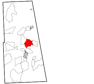
Cypress Quarters is a census-designated place (CDP) in Okeechobee County, Florida, United States. The population was 1,215 at the 2010 census.

<span class="mw-page-title-main">Fort Pierce North, Florida</span> CDP in Florida, United States

Fort Pierce North is a census-designated place (CDP) in St. Lucie County, Florida, United States. Per the 2020 census, the population was 6,904. It is part of the Port St. Lucie Metropolitan Statistical Area.

<span class="mw-page-title-main">Elma Center, New York</span> Census-designated place in New York, United States

Elma Center is a hamlet and census-designated place (CDP) in the town of Elma in Erie County, New York, United States. As of the 2010 census, this community population was 2,571. It is part of the Buffalo–Niagara Falls Metropolitan Statistical Area.

<span class="mw-page-title-main">Cherry Tree, Oklahoma</span> Census-designated place in Oklahoma, USA

Cherry Tree is a census-designated place (CDP) in Adair County, Oklahoma, United States. The population was 883 at the 2010 census, a decline of 26.5 percent from the figure of 1,202 recorded in 2000.

<span class="mw-page-title-main">Lyons Switch, Oklahoma</span> Census-designated place in Oklahoma, United States

Lyons Switch is a census-designated place (CDP) in Adair County, Oklahoma, United States. The population was 288 at the 2010 census.

<span class="mw-page-title-main">Peavine, Oklahoma</span> Census-designated place in Oklahoma, United States

Peavine is a census-designated place (CDP) in Adair County, Oklahoma, United States. The population was 423 at the 2010 census.

<span class="mw-page-title-main">Rocky Mountain, Oklahoma</span> Census-designated place in Oklahoma, United States

Rocky Mountain is a census-designated place (CDP) in Adair County, Oklahoma, United States. The population was 420 at the 2010 census.

<span class="mw-page-title-main">Dry Creek, Oklahoma</span> Census-designated place in Oklahoma, United States

Dry Creek is an unincorporated community and census-designated place (CDP) in Cherokee County, Oklahoma, United States. The population was 227 at the 2010 census.

Dwight Mission is a census-designated place (CDP) in Sequoyah County, Oklahoma, United States. It is part of the Fort Smith, Arkansas-Oklahoma Metropolitan Statistical Area. The population was 55 at the 2010 census, a 71.9 percent gain over the figure of 32 recorded in 2000. It is currently the home of Dwight Mission Presbyterian Camp & Retreat Center.

Evening Shade is a census-designated place (CDP) in Sequoyah County, Oklahoma, United States. It is part of the Fort Smith, Arkansas-Oklahoma Metropolitan Statistical Area. The population was 359 at the 2010 census.

Flute Springs is a census-designated place (CDP) in Sequoyah County, Oklahoma, United States. It is part of the Fort Smith, Arkansas-Oklahoma Metropolitan Statistical Area. The population was 182 at the 2000 census.

<span class="mw-page-title-main">McKey, Oklahoma</span> CDP in Oklahoma, United States

McKey is a census-designated place (CDP) in Sequoyah County, Oklahoma, United States. It is part of the Fort Smith, Arkansas-Oklahoma Metropolitan Statistical Area. The population was 135 at the 2000 census. McKey was established on the Old Osage and Arkansas Valley Railroad near MacKey's Salt Works. The post office existed from March 13, 1891, until July 14, 1928.

<span class="mw-page-title-main">Remy, Oklahoma</span> CDP in Oklahoma, United States

Remy is a census-designated place (CDP) in Sequoyah County, Oklahoma, United States. It is part of the Fort Smith, Arkansas-Oklahoma Metropolitan Statistical Area. The population was 411 at the 2000 census.

Short is a census-designated place (CDP) in Sequoyah County, Oklahoma, United States. It is part of the Fort Smith, Arkansas-Oklahoma Metropolitan Statistical Area. The population was 328 at the 2000 census.

Stony Point is a census-designated place (CDP) in Sequoyah County, Oklahoma, United States. It is part of the Fort Smith, Arkansas-Oklahoma Metropolitan Statistical Area. The population was 177 at the 2000 census.

<span class="mw-page-title-main">Olmito, Texas</span> Census-designated place in Texas, United States

Olmito is a census-designated place (CDP) in Cameron County, Texas, United States. Olmito is Spanish for "little elm". The population was 1,210 at the 2010 census. It is part of the Brownsville–Harlingen Metropolitan Statistical Area. Olmito is the self-described "mesquite capital of the world."

<span class="mw-page-title-main">Jefferson Valley, New York</span> Census-designated place in New York, United States

Jefferson Valley-Yorktown, commonly known as Jefferson Valley, is a census-designated place (CDP) located in the town of Yorktown in Westchester County, New York, United States. The population was 14,142 at the 2010 census. It is a hot spot for local shoppers, due to its Jefferson Valley Mall.

<span class="mw-page-title-main">Limestone (CDP), Maine</span> Census-designated place in Maine, United States

Limestone is a census-designated place (CDP) comprising the main village within the town of Limestone in Aroostook County, Maine, United States. The population was 1,075 at the 2010 census, out of a population of 2,314 for the entire town.

References

  1. "US Gazetteer files: 2010, 2000, and 1990". United States Census Bureau. 2011-02-12. Retrieved 2011-04-23.
  2. "U.S. Census website". United States Census Bureau . Retrieved 2008-01-31.