McKey, Oklahoma

Last updated
McKey, Oklahoma
CDP
OKMap-doton-McKey.PNG
Location of McKey, Oklahoma
Map of MacKey Salt Works 1887.png
Location of MacKey's Salt Works in the old Cherokee Nation
Coordinates: 35°29′3″N94°50′30″W / 35.48417°N 94.84167°W / 35.48417; -94.84167
Country United States
State Oklahoma
County Sequoyah
Area
  Total5.9 sq mi (15.4 km2)
  Land5.8 sq mi (15.1 km2)
  Water0.1 sq mi (0.2 km2)
Elevation
525 ft (160 m)
Population
 (2000)
  Total135
  Density23.1/sq mi (8.9/km2)
Time zone UTC-6 (Central (CST))
  Summer (DST) UTC-5 (CDT)
FIPS code 40-45050 [1]
GNIS feature ID1100617 [2]

McKey is a census-designated place (CDP) in Sequoyah County, Oklahoma, United States. It is part of the Fort Smith, Arkansas-Oklahoma Metropolitan Statistical Area. The population was 135 at the 2000 census. McKey was established on the Old Osage and Arkansas Valley Railroad near MacKey's Salt Works. The post office existed from March 13, 1891, until July 14, 1928.

Contents

Geography

McKey is located at 35°29′3″N94°50′30″W / 35.48417°N 94.84167°W / 35.48417; -94.84167 (35.484263, -94.841796). [3]

According to the United States Census Bureau, the CDP has a total area of 5.9 square miles (15 km2), of which 5.8 square miles (15 km2) is land and 0.1 square miles (0.26 km2) (1.52%) is water.

Demographics

As of the census [1] of 2000, there were 135 people, 55 households, and 38 families residing in the CDP. The population density was 23.1 inhabitants per square mile (8.9/km2). There were 61 housing units at an average density of 10.5 per square mile (4.1/km2). The racial makeup of the CDP was 62.22% White, 21.48% Native American, and 16.30% from two or more races.

There were 55 households, out of which 36.4% had children under the age of 18 living with them, 61.8% were married couples living together, 5.5% had a female householder with no husband present, and 30.9% were non-families. 25.5% of all households were made up of individuals, and 12.7% had someone living alone who was 65 years of age or older. The average household size was 2.45 and the average family size was 2.92.

In the CDP, the population was spread out, with 26.7% under the age of 18, 1.5% from 18 to 24, 33.3% from 25 to 44, 25.2% from 45 to 64, and 13.3% who were 65 years of age or older. The median age was 36 years. For every 100 females, there were 104.5 males. For every 100 females age 18 and over, there were 94.1 males.

The median income for a household in the CDP was $24,732, and the median income for a family was $41,528. Males had a median income of $26,250 versus $16,250 for females. The per capita income for the CDP was $15,696. None of the population and none of the families were below the poverty line.

Related Research Articles

<span class="mw-page-title-main">Traver, California</span> Census-designated place in California, United States

Traver is a census-designated place (CDP) in Tulare County, California, United States. The population was 713 at the 2010 census, down from 732 at the 2000 census.

<span class="mw-page-title-main">Burt, Michigan</span> Census-designated place & unincorporated community in Michigan, United States

Burt is a census-designated place (CDP) and Unincorporated community for statistical purposes in Taymouth Township, Saginaw County in the U.S. state of Michigan. The CDP's population was 1,122 at the 2000 census. Burt is also the name of a post office with ZIP code 48417, which includes the area of the CDP as well as portions of Taymouth Township to the north of the CDP and the eastern part of Albee Township and a small area of southeastern Spaulding Township. The town is named for Wellington R. Burt.

<span class="mw-page-title-main">Valley Hill, North Carolina</span> Census-designated place in North Carolina, United States

Valley Hill is an unincorporated community and census-designated place (CDP) in Henderson County, North Carolina, United States. The population was 2,070 at the 2010 census. It is part of the Asheville Metropolitan Statistical Area.

<span class="mw-page-title-main">Cherry Tree, Oklahoma</span> Census-designated place in Oklahoma, USA

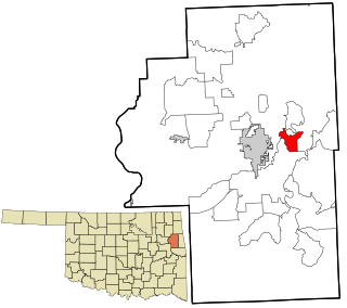
Cherry Tree is a census-designated place (CDP) in Adair County, Oklahoma, United States. The population was 883 at the 2010 census, a decline of 26.5 percent from the figure of 1,202 recorded in 2000.

<span class="mw-page-title-main">Christie, Oklahoma</span> CDP in Oklahoma, United States

Christie is a census-designated place (CDP) in Adair County, Oklahoma, United States. The population was 218 at the 2010 census, a 31.3 percent increase over the figure of 166 recorded in 2000.

<span class="mw-page-title-main">Greasy, Oklahoma</span> Census-designated place in Oklahoma, United States

Greasy is a census-designated place (CDP) in Adair County, Oklahoma, United States. The population was 372 at the 2010 census.

<span class="mw-page-title-main">Lyons Switch, Oklahoma</span> Census-designated place in Oklahoma, United States

Lyons Switch is a census-designated place (CDP) in Adair County, Oklahoma, United States. The population was 288 at the 2010 census.

<span class="mw-page-title-main">Marietta, Adair County, Oklahoma</span> Census-designated place in Oklahoma, United States

Marietta is a census-designated place (CDP) in Adair County, Oklahoma, United States. The population was 106 at the 2010 census. The community was listed as Maryetta at the 2000 census, at which time it had a population of 138.

<span class="mw-page-title-main">West Peavine, Oklahoma</span> Census-designated place in Oklahoma, United States

West Peavine is a census-designated place (CDP) in Adair County, Oklahoma, United States. The population was 218 at the 2010 census.

<span class="mw-page-title-main">Briggs, Oklahoma</span> Census-designated place in Oklahoma, United States

Briggs is an unincorporated community and census-designated place (CDP) in Cherokee County, Oklahoma, United States. The population was 303 at the 2010 census.

<span class="mw-page-title-main">Dry Creek, Oklahoma</span> Census-designated place in Oklahoma, United States

Dry Creek is an unincorporated community and census-designated place (CDP) in Cherokee County, Oklahoma, United States. The population was 227 at the 2010 census.

<span class="mw-page-title-main">Tenkiller, Oklahoma</span> Census-designated place in Oklahoma, United States

Tenkiller is an unincorporated community and census-designated place (CDP) in Cherokee County, Oklahoma, United States. The population was 633 at the 2010 census.

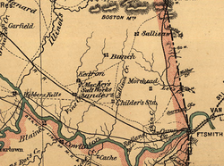
Flute Springs is a census-designated place (CDP) in Sequoyah County, Oklahoma, United States. It is part of the Fort Smith, Arkansas-Oklahoma Metropolitan Statistical Area. The population was 182 at the 2000 census.

<span class="mw-page-title-main">Long, Oklahoma</span> CDP in Oklahoma, United States

Long is a census-designated place (CDP) in Sequoyah County, Oklahoma, United States. It is part of the Fort Smith, Arkansas-Oklahoma Metropolitan Statistical Area. The population was 363 at the 2000 census.

Marble City Community is a census-designated place (CDP) in Sequoyah County, Oklahoma, United States. It is part of the Fort Smith, Arkansas-Oklahoma Metropolitan Statistical Area. The population was 420 at the 2000 census.

Pinhook Corners is a census-designated place (CDP) in Sequoyah County, Oklahoma, United States. It is part of the Fort Smith, Arkansas-Oklahoma Metropolitan Statistical Area. The population was 161 at the 2000 census.

<span class="mw-page-title-main">Remy, Oklahoma</span> CDP in Oklahoma, United States

Remy is a census-designated place (CDP) in Sequoyah County, Oklahoma, United States. It is part of the Fort Smith, Arkansas-Oklahoma Metropolitan Statistical Area. The population was 411 at the 2000 census.

Short is a census-designated place (CDP) in Sequoyah County, Oklahoma, United States. It is part of the Fort Smith, Arkansas-Oklahoma Metropolitan Statistical Area. The population was 328 at the 2000 census.

Stony Point is a census-designated place (CDP) in Sequoyah County, Oklahoma, United States. It is part of the Fort Smith, Arkansas-Oklahoma Metropolitan Statistical Area. The population was 177 at the 2000 census.

Sycamore is a census-designated place (CDP) in Sequoyah County, Oklahoma, United States. It is part of the Fort Smith, Arkansas-Oklahoma Metropolitan Statistical Area. The population was 150 at the 2000 census.

References

  1. 1 2 "U.S. Census website". United States Census Bureau . Retrieved 2008-01-31.
  2. "US Board on Geographic Names". United States Geological Survey. 2007-10-25. Retrieved 2008-01-31.
  3. "US Gazetteer files: 2010, 2000, and 1990". United States Census Bureau. 2011-02-12. Retrieved 2011-04-23.

Further reading

Shirk, George H.; Oklahoma Place Names; University of Oklahoma Press; Norman, Oklahoma; 1987: ISBN   0-8061-2028-2.