Stony Point, Oklahoma

Last updated

Stony Point, Oklahoma
CDP
USA Oklahoma location map.svg
Red pog.svg
Stony Point, Oklahoma
Location within the state of Oklahoma
Coordinates: 35°35′45″N94°39′47″W / 35.59583°N 94.66306°W / 35.59583; -94.66306
Country United States
State Oklahoma
County Sequoyah
Area
[1]
  Total22.72 sq mi (58.85 km2)
  Land22.68 sq mi (58.75 km2)
  Water0.04 sq mi (0.10 km2)
Elevation
[2]
1,322 ft (403 m)
Population
 (2020)
  Total176
  Density7.76/sq mi (3.00/km2)
Time zone UTC-6 (Central (CST))
  Summer (DST) UTC-5 (CDT)
FIPS code 40-70575 [3]
GNIS feature ID1853484 [2]

Stony Point is a census-designated place (CDP) in Sequoyah County, Oklahoma, United States. It is part of the Fort Smith, Arkansas-Oklahoma Metropolitan Statistical Area. The population was 177 at the 2000 census.

Contents

Geography

According to the United States Census Bureau, the CDP has a total area of 22.9 square miles (59 km2), of which 22.8 square miles (59 km2) is land and 0.04 square miles (0.10 km2) (0.09%) is water.

Demographics

Historical population
CensusPop.Note
2020 176
U.S. Decennial Census [4]

As of the census [2] of 2000, there were 177 people, 66 households, and 54 families residing in the CDP. The population density was 7.7 inhabitants per square mile (3.0/km2). There were 88 housing units at an average density of 3.9 per square mile (1.5/km2). The racial makeup of the CDP was 55.93% White, 27.68% Native American, and 16.38% from two or more races. Hispanic or Latino of any race were 1.69% of the population.

There were 66 households, out of which 33.3% had children under the age of 18 living with them, 65.2% were married couples living together, 13.6% had a female householder with no husband present, and 16.7% were non-families. 15.2% of all households were made up of individuals, and 7.6% had someone living alone who was 65 years of age or older. The average household size was 2.68 and the average family size was 2.93.

In the CDP, the population was spread out, with 25.4% under the age of 18, 7.3% from 18 to 24, 28.8% from 25 to 44, 24.9% from 45 to 64, and 13.6% who were 65 years of age or older. The median age was 38 years. For every 100 females, there were 115.9 males. For every 100 females age 18 and over, there were 109.5 males.

The median income for a household in the CDP was $28,750, and the median income for a family was $33,125. Males had a median income of $26,667 versus $22,500 for females. The per capita income for the CDP was $11,652. About 23.0% of families and 27.4% of the population were below the poverty line, including 42.5% of those under the age of eighteen and 50.0% of those 65 or over.

Related Research Articles

<span class="mw-page-title-main">Stony River, Alaska</span> Census-designated place in Alaska, United States

Stony River is a census-designated place (CDP) in Bethel Census Area, Alaska, United States. The population was 54 at the 2010 census, down from 61 in 2000.

<span class="mw-page-title-main">Stony Point, Michigan</span> Census-designated place & unincorporated community in Michigan, United States

Stony Point is an unincorporated community and census-designated place (CDP) in Monroe County in the U.S. state of Michigan. The population was 1,784 at the 2020 census. The CDP is located within Frenchtown Charter Township.

<span class="mw-page-title-main">Stony Prairie, Ohio</span> CDP in Ohio, United States

Stony Prairie is a census-designated place (CDP) in Sandusky County, Ohio, United States. The population was 1,218 at the 2020 census.

<span class="mw-page-title-main">Cherry Tree, Oklahoma</span> Census-designated place in Oklahoma, USA

Cherry Tree is a census-designated place (CDP) in Adair County, Oklahoma, United States. The population was 883 at the 2010 census, a decline of 26.5 percent from the figure of 1,202 recorded in 2000.

<span class="mw-page-title-main">Christie, Oklahoma</span> CDP in Oklahoma, United States

Christie is a census-designated place (CDP) in Adair County, Oklahoma, United States. The population was 218 at the 2010 census, a 31.3 percent increase over the figure of 166 recorded in 2000.

<span class="mw-page-title-main">Peavine, Oklahoma</span> Census-designated place in Oklahoma, United States

Peavine is a census-designated place (CDP) in Adair County, Oklahoma, United States. The population was 423 at the 2010 census.

<span class="mw-page-title-main">West Peavine, Oklahoma</span> Census-designated place in Oklahoma, United States

West Peavine is a census-designated place (CDP) in Adair County, Oklahoma, United States. The population was 218 at the 2010 census.

Sycamore is a census-designated place (CDP) in Delaware County, Oklahoma, United States. The population was 177 at the 2010 census.

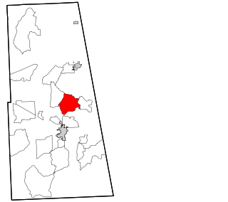
McCord is a census-designated place (CDP) in Osage County, Oklahoma, United States. The population was 1,440 at the 2010 census, a decrease of 15.8 percent from the figure of 1,711 reported in 2000.

<span class="mw-page-title-main">Bushyhead, Oklahoma</span> CDP in Oklahoma, United States

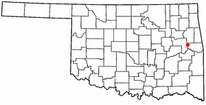
Bushyhead is a census-designated place (CDP) in Rogers County, Oklahoma, United States. The population was 1,314 at the 2010 census, a 9.2 percent increase over the figure of 1,203 recorded in 2000. Established on the St. Louis-San Francisco Railway between Claremore and Vinita, the community was named for Dennis W. Bushyhead, Principal Chief of the Cherokee, 1879–1887. The post office existed from April 18, 1898, until November 15, 1955.

Belfonte is a census-designated place (CDP) in Sequoyah County, Oklahoma, United States. It is part of the Fort Smith, Arkansas-Oklahoma Metropolitan Statistical Area. The population was 426 at the 2000 census.

<span class="mw-page-title-main">Brushy, Oklahoma</span> CDP in Oklahoma, United States

Brushy is a census-designated place (CDP) in Sequoyah County, Oklahoma, United States, along U.S. Route 59 in the foothills of the Brushy Mountains. It is part of the Fort Smith, Arkansas-Oklahoma Metropolitan Statistical Area. The population was 900 at the 2010 census, an increase of 14.4 percent over the figure of 787 recorded in 2000.

Carlisle is a census-designated place (CDP) in Sequoyah County, Oklahoma, United States. It is part of the Fort Smith, Arkansas-Oklahoma Metropolitan Statistical Area. The population was 606 at the 2010 census.

Flute Springs is a census-designated place (CDP) in Sequoyah County, Oklahoma, United States. It is part of the Fort Smith, Arkansas-Oklahoma Metropolitan Statistical Area. The population was 182 at the 2000 census.

Marble City Community is a census-designated place (CDP) in Sequoyah County, Oklahoma, United States. It is part of the Fort Smith, Arkansas-Oklahoma Metropolitan Statistical Area. The population was 420 at the 2000 census.

<span class="mw-page-title-main">Notchietown, Oklahoma</span> CDP in Oklahoma, United States

Notchietown is a census-designated place (CDP) in Sequoyah County, Oklahoma, United States. It is part of the Fort Smith, Arkansas-Oklahoma Metropolitan Statistical Area. The population was 430 at the 2000 census.

Short is a census-designated place (CDP) in Sequoyah County, Oklahoma, United States. It is part of the Fort Smith, Arkansas-Oklahoma Metropolitan Statistical Area. The population was 328 at the 2000 census.

<span class="mw-page-title-main">Willington, South Carolina</span> CDP in South Carolina, United States

Willington is a census-designated place (CDP) in McCormick County, South Carolina, United States. The population was 177 at the 2000 census.

<span class="mw-page-title-main">Oakhurst, Oklahoma</span> Census-designated place in Oklahoma, United States

Oakhurst is an unincorporated community and census-designated place (CDP) in Creek and Tulsa counties in the U.S. state of Oklahoma. The population was 2,262 at the 2020 census, a slight increase from the 2010 population of 2,185.

<span class="mw-page-title-main">Stony Point (CDP), New York</span> Census-designated place in New York, United States

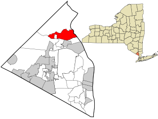
Stony Point is a hamlet and census-designated place in the town of Stony Point, Rockland County, New York, United States. It is located north of West Haverstraw, east of Harriman State Park, south of Tomkins Cove, and west of the Hudson River. The population was 12,147 at the 2010 census.

References

  1. "ArcGIS REST Services Directory". United States Census Bureau. Retrieved September 20, 2022.
  2. 1 2 3 U.S. Geological Survey Geographic Names Information System: Stony Point, Oklahoma
  3. "U.S. Census website". United States Census Bureau . Retrieved January 31, 2008.
  4. "Census of Population and Housing". Census.gov. Retrieved June 4, 2016.