
Cherry Tree is a census-designated place (CDP) in Adair County, Oklahoma, United States. The population was 883 at the 2010 census, a decline of 26.5 percent from the figure of 1,202 recorded in 2000.

Christie is a census-designated place (CDP) in Adair County, Oklahoma, United States. The population was 218 at the 2010 census, a 31.3 percent increase over the figure of 166 recorded in 2000.

Lyons Switch is a census-designated place (CDP) in Adair County, Oklahoma, United States. The population was 288 at the 2010 census.
Peavine is a census-designated place (CDP) in Adair County, Oklahoma, United States. The population was 423 at the 2010 census.

Rocky Mountain is a census-designated place (CDP) in Adair County, Oklahoma, United States. The population was 420 at the 2010 census.
Watts Community is a former census-designated place (CDP) in Adair County, Oklahoma, United States. The population was 500 at the 2000 census.

West Peavine is a census-designated place (CDP) in Adair County, Oklahoma, United States. The population was 218 at the 2010 census.
Briggs is an unincorporated community and census-designated place (CDP) in Cherokee County, Oklahoma, United States. The population was 303 at the 2010 census.

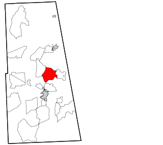
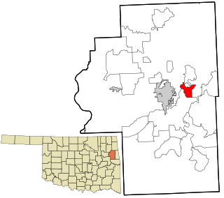
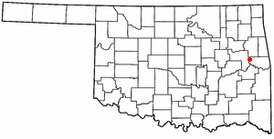
Welling is an unincorporated community and census-designated place (CDP) in Cherokee County, Oklahoma, United States. The population was 771 at the 2010 census, an increase of 15.25 percent over the figure of 669 recorded in 2000. It is home to The Salvation Army's Heart o' Hills camp and conference center.

Twin Oaks is an unincorporated community and census-designated place (CDP) in Delaware County, Oklahoma, United States. The population was 198 at the 2010 census. A tornado hit the town on March 12, 2006, destroying 36 homes and damaging 31 others. 8 people were injured.
Belfonte is a census-designated place (CDP) in Sequoyah County, Oklahoma, United States. It is part of the Fort Smith, Arkansas-Oklahoma Metropolitan Statistical Area. The population was 426 at the 2000 census.
Brent is a census-designated place (CDP) in Sequoyah County, Oklahoma, United States, south of Sallisaw. It is part of the Fort Smith, Arkansas-Oklahoma Metropolitan Statistical Area. The population was 504 at the 2000 census.

Brushy is a census-designated place (CDP) in Sequoyah County, Oklahoma, United States, along U.S. Route 59 in the foothills of the Brushy Mountains. It is part of the Fort Smith, Arkansas-Oklahoma Metropolitan Statistical Area. The population was 900 at the 2010 census, an increase of 14.4 percent over the figure of 787 recorded in 2000.
Carlisle is a census-designated place (CDP) in Sequoyah County, Oklahoma, United States. It is part of the Fort Smith, Arkansas-Oklahoma Metropolitan Statistical Area. The population was 606 at the 2010 census.
Flute Springs is a census-designated place (CDP) in Sequoyah County, Oklahoma, United States. It is part of the Fort Smith, Arkansas-Oklahoma Metropolitan Statistical Area. The population was 182 at the 2000 census.
Marble City Community is a census-designated place (CDP) in Sequoyah County, Oklahoma, United States. It is part of the Fort Smith, Arkansas-Oklahoma Metropolitan Statistical Area. The population was 420 at the 2000 census.
Notchietown is a census-designated place (CDP) in Sequoyah County, Oklahoma, United States. It is part of the Fort Smith, Arkansas-Oklahoma Metropolitan Statistical Area. The population was 430 at the 2000 census.
Redbird Smith is a census-designated place (CDP) in Sequoyah County, Oklahoma, United States. It is part of the Fort Smith, Arkansas-Oklahoma Metropolitan Statistical Area. The population was 411 at the 2000 census. It was named for Redbird Smith (Cherokee), who founded the Keetoowah Nighthawk Society in Indian Territory and established a ceremonial ground here for sacred rituals.
Stony Point is a census-designated place (CDP) in Sequoyah County, Oklahoma, United States. It is part of the Fort Smith, Arkansas-Oklahoma Metropolitan Statistical Area. The population was 177 at the 2000 census.
Sycamore is a census-designated place (CDP) in Sequoyah County, Oklahoma, United States. It is part of the Fort Smith, Arkansas-Oklahoma Metropolitan Statistical Area. The population was 150 at the 2000 census.

