
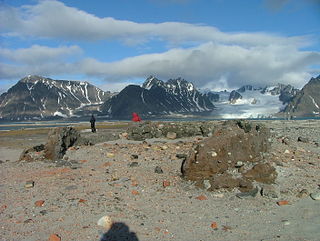
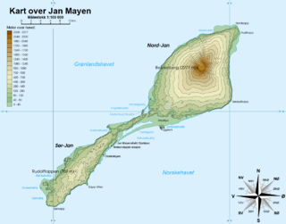
Jan Mayen is a Norwegian volcanic island in the Arctic Ocean with no permanent population. It is 55 km (34 mi) long (southwest-northeast) and 373 km2 (144 sq mi) in area, partly covered by glaciers. It has two parts: larger northeast Nord-Jan and smaller Sør-Jan, linked by a 2.5 km (1.6 mi) wide isthmus. It lies 600 km (370 mi) northeast of Iceland, 500 km (310 mi) east of central Greenland, and 900 km (560 mi) northwest of Vesterålen, Norway. The island is mountainous, the highest summit being the Beerenberg volcano in the north. The isthmus is the location of the two largest lakes of the island, Sørlaguna and Nordlaguna. A third lake is called Ullerenglaguna. Jan Mayen was formed by the Jan Mayen hotspot and is defined by geologists as a microcontinent.
Smeerenburg was a whaling settlement on Amsterdam Island in northwest Svalbard. It was founded by the Danish and Dutch in 1619 as one of Europe's northernmost outposts. With the local bowhead whale population soon decimated and whaling developed into a pelagic industry, Smeerenburg was abandoned around 1660.
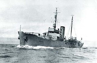
Fridtjof Nansen was the first ship in the Norwegian armed forces to be built specially to perform coast guard and fishery protection duties in the Arctic. She saw service in the Second World War with the Royal Norwegian Navy until she ran aground on an unmarked shallow at Jan Mayen in November 1940.
Kobbefjorden is a small fjord on the west coast of Danes Island, on the northwestern coast of Spitsbergen, the largest island of the Svalbard archipelago. The fjord is about two miles (3.5 km) long and 1-1.2 miles (1.5–2 km) wide. It offers one of the best anchorages on Spitsbergen's northwest coast, "being sheltered from most winds and ice-free for much of the year." At the head of the fjord is a valley, Kobbefjorddalen, which leads to the east coast of Danes Island. Kobbefjorden's southwesternmost point is Luftskipodden. Sir Martin Conway, on his visit to Spitsbergen in 1896-97, described the fjord as having "ice-smoothed hills of [the] hardest rock."

Willem Cornelisz. van Muyden was an early 17th-century mariner. He is known in the Netherlands as De Eerste Walvisvanger (1613). Van Muydenbukta and Van Mijenfjorden on the west coast of Spitsbergen and Kapp Muyen on the west coast of Jan Mayen are named after him.

Hoepstockbukta is a small cove on the western coast of the Norwegian island of Jan Mayen and is named after Mathijs Jansz. Hoepstock, a Rotterdam whaler, who was the first to use the bay in 1616. The cove is shown on Joan Blaeu's 1662 map of the island.
Engelskbukta is a broad, open bay mid-way up the west coast of the Norwegian island of Jan Mayen. It lies between Kapp Rudsen and Kvalrossen, comprising Kvalrossbukta and Tømmerbukta. Presumably this is where the English resorted to in 1616, when they sent their first whaling ships to the island. The Dutch whalers called it Noordbaai and used it for one of their two main whaling stations. In 1632 two Basque whaling ships plundered the station, causing the Dutch to send a wintering party of seven men in 1633–34. All perished.

Sjuhollendarbukta is a bay on the western coast of the island of Jan Mayen. The Austrian Emil von Wohlgemuth (1886), who surveyed Jan Mayen, named the bay 7 Holländer Bucht, mistakenly believing it was the site of the wintering of seven Dutch whalers in 1633–34.
Rekvedbukta is an open bay on the central southern coast of the island of Jan Mayen, about eight nautical miles long.
Titeltbukta is a bay on the northwestern coast of the Norwegian island of Jan Mayen. The name originates from the establishment of ten "tents", in reality wood and brick structures, as a basic whaling station. This was set up in 1624 by Dutch whalers to lodge the men who flensed the whales. The Dutch also called it Zuidbaai, in contrast to the other on the island, to the north at Engelskbukta).
Rooberg is a 50 m (165 ft) hill at Sjuhollendarbukta, a bay on the northwestern coast of the island of Jan Mayen. The hill is often mentioned during the Dutch wintering at Jan Mayen in 1633–34.
Gouwenaerbåen is a 10 m (33 ft) shoal or reef southeast of Eggøya, on the southern coast of the island of Jan Mayen. It is named after the Dutch seafarer Jacob de Gouwenaer, who was master of the Orangienboom in 1614, when he had first come upon the island. His name had originally been attached to Rekvedbukta.
Sørkapp is the southernmost point of the island Jan Mayen. The cape is some 455 km east of eastern Greenland, 910 km west northwest of mainland Norway (Lofoten) and 550 km northeast of northeastern Iceland.

Eggøya is a peninsula of Jan Mayen island of the Arctic Ocean. It is located on the southern side, in the central part of the island, east of Sørlaguna, and defines the northeastern extension of the bay Rekvedbukta. To the west of the peninsula is the bay Eggøybukta, and to the east is the bay Jamesonbukta. The highest peak at the peninsula has a height of 217 m.a.s.l. Eggøya consists of the northern part of an old volcanic crater, and small hydrothermal vents are still present. The outer part of the peninsula forms the semicircular bay of Kraterbukta, facing south-southeast with steep slopes. To the south of the peninsula is a small islet, Eggøykalven.
Nansenflua is an undersea rock in the northern part of Rekvedbukta off the southeastern coast of Jan Mayen in the Arctic Ocean. The shoal is named after the ship HNoMS Fridtjof Nansen, which sank after striking the previously uncharted rock in November 1940. Nansenflua is the only obstruction in Rekvedbukta. The name Nansenflua was introduced in charts published by the Norwegian Polar Institute in 1955, and is included as a recognized name in Anders K. Orvin's 1960 paper The place-names of Jan Mayen. It follows a convention based on two then in force Orders in Council, dated 28 April 1933 and 31 May 1957, of using the Nynorsk grammatical form. The suffix "-a" in the feminine definite form was chosen, as no local dialect existed on Jan Mayen. The last part of the name, "flu(a)", means "rock awash", or "sunken rock". The geographical location is given by Orvin as 70°57′N08°28′W, with an exactitude of 1'. The rock, located two meters under the surface, has a small top area and vertical sides of about twenty meters. It is located about one nautical mile from Eggøykalven and 1.7 nautical miles west-southwest of the peninsula Eggøya. In anything but completely calm weather conditions, Nansenflua is visible by waves being broken against it. The rock is part of the remains of a crater.
Trollsletta is a coastal plain on the North Arctic Ocean island of Jan Mayen.
Båtvika is a cove at the southern part of the island of Jan Mayen. It is located at the southeastern side of the island, in the southwestern part of Rekvedbukta, northeast of Kapp Traill. The settlement Olonkinbyen is located on the plain northeast of the cove, and Båtvika is the settlement's nearest harbour.
Kapp Traill is a headland at the southern part of the island of Jan Mayen. It defines the southwestern extension of the bay Rekvedbukta, at the southeast side of the island. The distance between Kapp Traill and Kapp Wien further southwest is about three nautical miles. The point is named after British zoologist Thomas Stewart Traill.
Eggøykalven is an islet south of the peninsula of Eggøya at the southern part of Jan Mayen. It is located just about 80 meters west of the point of Eggøyodden, and southeast of the bay Eggøybukta. The islet was earlier much higher, but has been significantly worn down by the ocean.
Maria Musch, was a Dutch shipowner. She was a major partner of the pioneer whaling company Kleine Noordse Compagnie (1616), which initiated the whaling industry around Jan Mayen. The bay Maria Muschbukta was named after her.
