
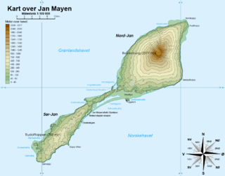
Jan Mayen is a Norwegian volcanic island in the Arctic Ocean with no permanent population. It is 55 km (34 mi) long (southwest-northeast) and 373 km2 (144 sq mi) in area, partly covered by glaciers. It has two parts: larger northeast Nord-Jan and smaller Sør-Jan, linked by a 2.5 km (1.6 mi) wide isthmus. It lies 600 km (370 mi) northeast of Iceland, 500 km (310 mi) east of central Greenland, and 900 km (560 mi) northwest of Vesterålen, Norway. The island is mountainous, the highest summit being the Beerenberg volcano in the north. The isthmus is the location of the two largest lakes of the island, Sørlaguna and Nordlaguna. A third lake is called Ullerenglaguna. Jan Mayen was formed by the Jan Mayen hotspot and is defined by geologists as a microcontinent.

The Norwegian Polar Institute is Norway's central governmental institution for scientific research, mapping and environmental monitoring in the Arctic and the Antarctic. The NPI is a directorate under Norway's Ministry of Climate and Environment. The institute advises Norwegian authorities on matters concerning polar environmental management and is the official environmental management body for Norwegian activities in Antarctica.

The Greenland Sea is a body of water that borders Greenland to the west, the Svalbard archipelago to the east, Fram Strait and the Arctic Ocean to the north, and the Norwegian Sea and Iceland to the south. The Greenland Sea is often defined as part of the Arctic Ocean, sometimes as part of the Atlantic Ocean. However, definitions of the Arctic Ocean and its seas tend to be imprecise or arbitrary. In general usage the term "Arctic Ocean" would exclude the Greenland Sea. In oceanographic studies the Greenland Sea is considered part of the Nordic Seas, along with the Norwegian Sea. The Nordic Seas are the main connection between the Arctic and Atlantic oceans and, as such, could be of great significance in a possible shutdown of thermohaline circulation. In oceanography the Arctic Ocean and Nordic Seas are often referred to collectively as the "Arctic Mediterranean Sea", a marginal sea of the Atlantic.

Norway has three dependent territories, all uninhabited and located in the Southern Hemisphere. Bouvet Island (Bouvetøya) is a sub-Antarctic island in the South Atlantic Ocean. Queen Maud Land is the sector of Antarctica between the 20th meridian west and the 45th meridian east. Peter I Island is a volcanic island located 450 kilometres (280 mi) off the coast of Ellsworth Land of continental Antarctica. Despite being unincorporated areas, neither Svalbard nor Jan Mayen is formally considered a dependency. While the Svalbard Treaty regulates some aspects of that Arctic territory, it acknowledges that the islands are part of Norway. Similarly, Jan Mayen is recognized as an integral part of Norway.

Rekvedbukta is an open bay on the central southern coast of the island of Jan Mayen, about eight nautical miles long.

Titeltbukta is a bay on the northwestern coast of the Norwegian island of Jan Mayen. The name originates from the establishment of ten "tents", in reality wood and brick structures, as a basic whaling station. This was set up in 1624 by Dutch whalers to lodge the men who flensed the whales. The Dutch also called it Zuidbaai, in contrast to the other on the island, to the north at Engelskbukta).
Torellneset is a headland at the southwestern side of Nordaustlandet, Svalbard. The headland is named after geologist Otto Martin Torell. It is located south of the glacier Vegafonna and is the southwestern point of Gustav Adolf Land. Outside the headland is the island of Perthesøya.
Reinhalvøya is a peninsula in Gustav V Land, at the northern coast of Nordaustlandet, Svalbard. It is located within the large bay Nordenskiöldbukta, south of Scoresbyøya and the Sabine Islands, and separates the bay of Sabinebukta from the bay Carolusbukta.
Rudolftoppen is a mountain on the island of Jan Mayen. It has a height of 769 m.a.s.l., and is the highest peak in the southern part of the island.
Sørlaguna is a lagoon on the island of Jan Mayen. It is the largest lake of Jan Mayen, and is located in the central part of the island, near the bay of Rekvedbukta.

Nordlaguna is a lagoon on the island of Jan Mayen. It is the second largest lake of Jan Mayen, after Sørlaguna, and is located in the central part of the island, near the bay of Stasjonsbukta. It was possibly formed by an eruption of Beerenberg volcano in 1732. Before isolation from the ocean 220 calyr BP what is now the Nordlaguna basin was a marine bay for about 2200 years. Before this, in a timespan between 2200 and 2400 calyr BP, it was mostly isolated from the ocean. This lake or lake-like period was preceded by at least 300–400 years of marine conditions.

Eggøya is a peninsula of Jan Mayen island of the Arctic Ocean. It is located on the southern side, in the central part of the island, east of Sørlaguna, and defines the northeastern extension of the bay Rekvedbukta. To the west of the peninsula is the bay Eggøybukta, and to the east is the bay Jamesonbukta. The highest peak at the peninsula has a height of 217 m.a.s.l. Eggøya consists of the northern part of an old volcanic crater, and small hydrothermal vents are still present. The outer part of the peninsula forms the semicircular bay of Kraterbukta, facing south-southeast with steep slopes. To the south of the peninsula is a small islet, Eggøykalven.
Jamesonbukta is a bay in the island of Jan Mayen. It is located east of Eggøya, on the southern side and central part of Jan Mayen.
Eggøybukta is a bay located on the island of Jan Mayen. It is located west of Eggøya, on the southern side and central part of Jan Mayen.
Hornbækbukta is a bay at the southeastern side of the Norwegian island of Jan Mayen. It has a width of 2.2 kilometers, and extends from the headland of Fugleodden to the southwest, to Kapp Wien to the northeast. The bay is named after hydrographer Helge Hornbæk.
Kapp Wien is a headland at the southeastern side of the island of Jan Mayen, about halfway between Olonkinbyen and Sørkapp. It defines the northeastern extension of the bay Hornbækbukta.
Nansenflua is an undersea rock in the northern part of Rekvedbukta off the southeastern coast of Jan Mayen in the Arctic Ocean. The shoal is named after the ship HNoMS Fridtjof Nansen, which sank after striking the previously uncharted rock in November 1940. Nansenflua is the only obstruction in Rekvedbukta. The name Nansenflua was introduced in charts published by the Norwegian Polar Institute in 1955, and is included as a recognized name in Anders K. Orvin's 1960 paper The place-names of Jan Mayen. It follows a convention based on two then in force Orders in Council, dated 28 April 1933 and 31 May 1957, of using the Nynorsk grammatical form. The suffix "-a" in the feminine definite form was chosen, as no local dialect existed on Jan Mayen. The last part of the name, "flu(a)", means "rock awash", or "sunken rock". The geographical location is given by Orvin as 70°57′N08°28′W, with an exactitude of 1'. The rock, located two meters under the surface, has a small top area and vertical sides of about twenty meters. It is located about one nautical mile from Eggøykalven and 1.7 nautical miles west-southwest of the peninsula Eggøya. In anything but completely calm weather conditions, Nansenflua is visible by waves being broken against it. The rock is part of the remains of a crater.
Båtvika is a cove at the southern part of the island of Jan Mayen. It is located at the southeastern side of the island, in the southwestern part of Rekvedbukta, northeast of Kapp Traill. The settlement Olonkinbyen is located on the plain northeast of the cove, and Båtvika is the settlement's nearest harbour.
Kapp Traill is a headland at the southern part of the island of Jan Mayen. It defines the southwestern extension of the bay Rekvedbukta, at the southeast side of the island. The distance between Kapp Traill and Kapp Wien further southwest is about three nautical miles. The point is named after British zoologist Thomas Stewart Traill.
Eggøykalven is an islet south of the peninsula of Eggøya at the southern part of Jan Mayen. It is located just about 80 meters west of the point of Eggøyodden, and southeast of the bay Eggøybukta. The islet was earlier much higher, but has been significantly worn down by the ocean.
