Olonkinbyen

Last updated
Olonkinbyen
Locale
( de facto capital of Jan Mayen)
Jan mayen-station hg.jpg
Olonkinbyen on Jan Mayen island
Etymology: Olonkin City
Europe blank laea location map.svg
Red pog.svg
Olonkinbyen
Location of Olonkinbyen in Europe
Coordinates: 70°55′19″N8°42′54″W / 70.92194°N 8.71500°W / 70.92194; -8.71500
CountryFlag of Norway.svg  Norway
ISO Svalbard and Jan Mayen
Island Jan Mayen
Established1962 (1962)
Population
  Totalc.18
Time zone UTC+01:00 (CET)
  Summer (DST) UTC+02:00 (CEST)
Website jan.mayen.no
Olonkinbyen on Jan Mayen map Jan Mayen topography no.png
Olonkinbyen on Jan Mayen map

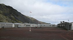
Olonkinbyen[ needs IPA ] (literally The Olonkin Town) is the only settlement on the Norwegian island of Jan Mayen (aside from isolated cottage huts such as Puppebu [1] ). It was named after Russian-Norwegian explorer Gennady Olonkin. [2]

Contents

The only inhabitants on the island are the 18 personnel, 14 working for the Norwegian Armed Forces and 4 for the Norwegian Meteorological Institute, but can have up to 35 people inhabiting the island at any given time. Olonkinbyen houses the staff that operate the meteorological observation station, Loran-C station, Jan Mayensfield air field and other infrastructure. The meteorological observation service staff are responsible for the radiosonde releases and synoptic weather observations. The crew of the meteorological station is engaged for six months at a time. [3] [4]

Supplies are delivered eight times a year by aircraft. Fuel and heavy goods are transported by boat during the summer. The settlement generates its own electrical power via three generators. [5] [6]

Climate

Olonkinbyen has a tundra climate (Köppen classified as ET), the warmest month is August and the coldest month is March.

Climate data for Olonkinbyen
MonthJanFebMarAprMayJunJulAugSepOctNovDecYear
Mean daily maximum °C (°F)−5
(23)
−5
(23)
−5
(23)
−3
(27)
0
(32)
3
(37)
5
(41)
5
(41)
3
(37)
1
(34)
−2
(28)
−4
(25)
−1
(31)
Mean daily minimum °C (°F)−10
(14)
−11
(12)
−11
(12)
−9
(16)
−5
(23)
−2
(28)
0
(32)
1
(34)
−1
(30)
−4
(25)
−7
(19)
−9
(16)
−6
(22)
Average precipitation cm (inches)7.6
(3)
5.1
(2)
7.6
(3)
5.1
(2)
5.1
(2)
5.1
(2)
5.1
(2)
7.6
(3)
7.6
(3)
10
(4)
7.6
(3)
7.6
(3)
81.1
(32)
Source: [7]

Related Research Articles

<span class="mw-page-title-main">Jan Mayen</span> Norwegian island in the Arctic Ocean

Jan Mayen is a Norwegian volcanic island in the Arctic Ocean with no permanent population. It is 55 km (34 mi) long (southwest-northeast) and 373 km2 (144 sq mi) in area, partly covered by glaciers. It has two parts: larger northeast Nord-Jan and smaller Sør-Jan, linked by a 2.5 km (1.6 mi) wide isthmus. It lies 600 km (370 mi) northeast of Iceland, 500 km (310 mi) east of central Greenland, and 900 km (560 mi) northwest of Vesterålen, Norway.

<span class="mw-page-title-main">Svalbard</span> Norwegian archipelago in the Arctic Ocean

Svalbard, previously known as Spitsbergen or Spitzbergen, is a Norwegian archipelago in the Arctic Ocean. North of mainland Europe, it lies about midway between the northern coast of Norway and the North Pole. The islands of the group range from 74° to 81° north latitude, and from 10° to 35° east longitude. The largest island is Spitsbergen, followed in size by Nordaustlandet and Edgeøya. The largest settlement is Longyearbyen on the west coast of Spitsbergen.

<span class="mw-page-title-main">Bear Island (Svalbard)</span> Southernmost island of Svalbard, Norway

Bear Island is the southernmost island of the Norwegian Svalbard archipelago. The island is located at the limits of the Norwegian and Barents seas, approximately halfway between Spitsbergen and the North Cape. Bear Island was discovered by Dutch explorers Willem Barentsz and Jacob van Heemskerck on 10 June 1596. It was named after a polar bear that was seen swimming nearby. The island was considered terra nullius until the Spitsbergen Treaty of 1920 placed it under Norwegian sovereignty.

<span class="mw-page-title-main">Svalbard and Jan Mayen</span> Two parts of Norway under separate jurisdictions

Svalbard and Jan Mayen is a statistical designation defined by ISO 3166-1 for a collective grouping of two remote jurisdictions of Norway: Svalbard and Jan Mayen. While the two are combined for the purposes of the International Organization for Standardization (ISO) category, they are not administratively related. This has further resulted in the country code top-level domain .sj being issued for Svalbard and Jan Mayen, and ISO 3166-2:SJ. The United Nations Statistics Division also uses this code, but has named it the Svalbard and Jan Mayen Islands.

<span class="mw-page-title-main">Hopen (Svalbard)</span> Island in the southeastern part of the Svalbard archipelago, Norway

Hopen is an island in the southeastern part of the Svalbard archipelago (Norway). Hopen was discovered in 1596 by Jan Cornelisz Rijp during the third expedition by Willem Barentsz, trying to find the Northeast Passage. Later, in 1613, its name was given by Thomas Marmaduke of Hull, who named it after his former command, the Hopewell.

<span class="mw-page-title-main">Greenland Sea</span> Body of water

The Greenland Sea is a body of water that borders Greenland to the west, the Svalbard archipelago to the east, Fram Strait and the Arctic Ocean to the north, and the Norwegian Sea and Iceland to the south. The Greenland Sea is often defined as part of the Arctic Ocean, sometimes as part of the Atlantic Ocean. However, definitions of the Arctic Ocean and its seas tend to be imprecise or arbitrary. In general usage the term "Arctic Ocean" would exclude the Greenland Sea. In oceanographic studies the Greenland Sea is considered part of the Nordic Seas, along with the Norwegian Sea. The Nordic Seas are the main connection between the Arctic and Atlantic oceans and, as such, could be of great significance in a possible shutdown of thermohaline circulation. In oceanography the Arctic Ocean and Nordic Seas are often referred to collectively as the "Arctic Mediterranean Sea", a marginal sea of the Atlantic.

<span class="mw-page-title-main">Honningsvåg</span> City/town within Nordkapp Municipality, Finnmark, Norway

Honningsvåg is the northernmost city/town in mainland Norway. It is located in Nordkapp Municipality in Finnmark county. Honningsvåg was declared a city in 1996, despite its small population. The 1.04-square-kilometre (260-acre) town has a population of 2,245 (2023), which gives the town a population density of 2,159 inhabitants per square kilometre (5,590/sq mi).

HNoMS <i>Fridtjof Nansen</i> (1930)

Fridtjof Nansen was the first ship in the Norwegian armed forces to be built specially to perform coast guard and fishery protection duties in the Arctic. She saw service in the Second World War with the Royal Norwegian Navy until she ran aground on an unmarked shallow at Jan Mayen in November 1940.

The LORAN-C transmitter Jan Mayen was a LORAN-C transmission facility on the island of Jan Mayen at 70°54′51″N8°43′57″W. The LORAN-C transmitter Jan Mayen used as an antenna had a 190-metre tall (625 ft) guyed mast.

Jan Mayensfield is an aerodrome serving Olonkinbyen in Jan Mayen, Norway. Operated by the Norwegian Armed Forces, it serves the island's only population at the combined military and meteorological station. It has a 1,500-meter (4,921 ft) dirt runway numbered 04–22.

<span class="mw-page-title-main">Rekvedbukta (Jan Mayen)</span> Bay of Jan Mayen

Rekvedbukta is an open bay on the central southern coast of the island of Jan Mayen, about eight nautical miles long.

<span class="mw-page-title-main">Titeltbukta</span> Bay

Titeltbukta is a bay on the northwestern coast of the Norwegian island of Jan Mayen. The name originates from the establishment of ten "tents", in reality wood and brick structures, as a basic whaling station. This was set up in 1624 by Dutch whalers to lodge the men who flensed the whales. The Dutch also called it Zuidbaai, in contrast to the other on the island, to the north at Engelskbukta).

<span class="mw-page-title-main">Gennady Olonkin</span>

Gennady Nikitich Olonkin was a Russian-Norwegian polar explorer, telegraphist and radio operator.

<span class="mw-page-title-main">Hopen Radio</span> Coast radio station in Norway

Hopen Radio is a coast radio station and the only settlement on the island of Hopen in Svalbard, Norway. It is located between Kollerfjellet and Werenskioldfjellet.

Sonne was a radio navigation system developed in Germany during World War II. It was developed from an earlier experimental system known as Elektra, and therefore the system is also known as Elektra-sonnen. When the British learned of the system they started using it as well, under the name Consol, meaning "by the sun".

<span class="mw-page-title-main">Sørlaguna</span>

Sørlaguna is a lagoon on the island of Jan Mayen. It is the largest lake of Jan Mayen, and is located in the central part of the island, near the bay of Rekvedbukta.

<span class="mw-page-title-main">Kapp Wien</span> Headland on Jan Mayen, Norway

Kapp Wien is a headland at the southeastern side of the island of Jan Mayen, about halfway between Olonkinbyen and Sørkapp. It defines the northeastern extension of the bay Hornbækbukta.

<span class="mw-page-title-main">Trollsletta</span> Coastal plain in Jan Mayen, Norway

Trollsletta is a coastal plain on the North Arctic Ocean island of Jan Mayen.

<span class="mw-page-title-main">Båtvika</span> Cove on the island of Jan Mayen in Norway

Båtvika is a cove at the southern part of the island of Jan Mayen. It is located at the southeastern side of the island, in the southwestern part of Rekvedbukta, northeast of Kapp Traill. The settlement Olonkinbyen is located on the plain northeast of the cove, and Båtvika is the settlement's nearest harbour.

Puppebu is one of nine small cabins in the Norwegian island Jan Mayen. It is bordered by the Bay of Walrus. Although Puppebu does not exceed 3 temporary inhabitants, there is a small stone road, called Jan Mayenveien, that runs from Puppebu on the north of the island to Olonkinbyen. Every month, a ship takes supplies to the town, but during the winter season it cannot be accessed from the bay because large blocks of ice form in the water.

References

  1. http://jan.mayen.no/hytter-pa-jan-mayen/ (In Norwegian)
  2. "Gennadij Olonkin". polarhistorie.no. Retrieved October 1, 2016.
  3. "Loran Station Jan Mayen". loran-history.info. Retrieved October 1, 2016.
  4. "Jan Mayen - Airfield "Jan Mayensfield"". Jan Mayensfield. Retrieved October 1, 2016.
  5. Images and Information on Olonkin City Archived 2006-05-22 at the Wayback Machine
  6. "Oppgavene på Jan Mayen". Meteorologisk institutt. Retrieved October 1, 2016.
  7. World Climate Guide

70°55′19″N8°42′54″W / 70.922°N 8.715°W / 70.922; -8.715