Rekvedbukta (English: Driftwood Bay) is an open bay on the central southern coast of the island of Jan Mayen, about eight nautical miles long.
Contents

Rekvedbukta (English: Driftwood Bay) is an open bay on the central southern coast of the island of Jan Mayen, about eight nautical miles long.
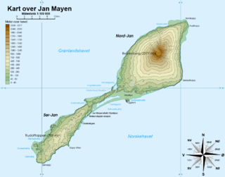
The bay extends from the point Kapp Traill to the south and northeastwards to the peninsula of Eggøya. It has a length of about eight nautical miles. The only inhabited site on Jan Mayen, Olonkinbyen, is located at the plain Trollsletta at the southern part of the bay. South of the settlement is the harbour Båtvika. The aerodrome Jan Mayensfield is located northeast of Olonkinbyen, along Rekvedbukta. Further northeast is the shallow elongated lake Sørlaguna, which can extend up to eight kilometers in the spring, separated from the bay by the sandy bar Lagunevollen. Eggøybukta at the northeastern part of the bay is a suitable harbour under favourable weather conditions. The bay contains the islet of Losbåten and the shoal Losbåtrevet to the southwest. In the northeastern part of the bay is the shoal Nansenflua, named after the ship HNoMS Fridtjof Nansen, which was wrecked and sank after striking the rock in November 1940. [1] [2]
The oldest reference given by Orvin in his 1960 paper The place-names of Jan Mayen, is a description from 1614 by Dutch cartographer Joris Carolus. Carolus introduces the name Gouwenaers Bay after captain Jacob de Gouwenaer. In Joan Blaeu's Atlas Major sive Cosmographia Blaviana from 1662 the bay is called Groote Hout Bay, while in a publication from 1720 Zorgdrager uses the form Groote Hout baay. Other names used over the time are Grand Baye au Bois, Great Wood Bay, La baie du Grand-Bois, Treibholz Bucht, Rækved Bugt, Baie du Bois-flotté, Dirvtræbugt, Drivtømmerbugt, Driftwood Bay and Drivvedsbugten. The first part of the name Rekvedbukta means "driftwood", while bukt(a) means "bay", "bight" or "cove". [3]

Jan Mayen is a Norwegian volcanic island in the Arctic Ocean, with no permanent population. It is 55 km (34 mi) long (southwest-northeast) and 373 km2 (144 sq mi) in area, partly covered by glaciers [an area of 114.2 km2 (44.1 sq mi) around the Beerenberg volcano. It has two parts: larger northeast Nord-Jan and smaller Sør-Jan, linked by a 2.5 km (1.6 mi) wide isthmus. It lies 600 km (370 mi) northeast of Iceland, 500 km (310 mi) east of central Greenland and 1,000 km (620 mi) west of the North Cape, Norway. The island is mountainous, the highest summit being the Beerenberg volcano in the north. The isthmus is the location of the two largest lakes of the island, Sørlaguna, and Nordlaguna. A third lake is called Ullerenglaguna. Jan Mayen was formed by the Jan Mayen hotspot.
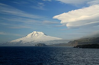
Beerenberg is a stratovolcano dominating the northeastern end of the Norwegian island of Jan Mayen. It is 2,277 m (7,470 ft) high and is the world's northernmost subaerial active volcano. The volcano is topped by a mostly ice-filled crater about 1 km (0.6 mi) wide, with numerous peaks along its rim including the highest summit, Haakon VII Toppen, on its western side.

Olonkinbyen is the only settlement on the Norwegian island of Jan Mayen. It was named after Russian-Norwegian explorer Gennady Olonkin.

Jan Mayensfield is an aerodrome serving Olonkinbyen in Jan Mayen, Norway. Operated by the Norwegian Armed Forces, it serves the island's only population at the combined military and meteorological station. It has a 1,500-meter (4,921 ft) dirt runway numbered 06–24.
Anders Kristian Orvin was a Norwegian geologist and explorer.

Maria Muschbukta is an open bay between Fulgeberget and Kvalrossen, on the western coast of the Norwegian island of Jan Mayen. It is named after the shipowner Maria Musch. She was a member of the Kleine Noordse Compagnie, which sent a ship to Jan Mayen in 1616 as part of early Dutch whaling. This ship was the first to use the bay to hunt whales. The name is shown on Joan Blaeu's 1662 map of the island.
Gouwenaerbåen is a 10 m (33 ft) shoal or reef southeast of Eggøya, on the southern coast of the island of Jan Mayen. It is named after the Dutch seafarer Jacob de Gouwenaer, who was master of the Orangienboom in 1614, when he had first come upon the island. His name had originally been attached to Rekvedbukta.
Signehamna is a bay and natural harbour in Albert I Land at Spitsbergen, Svalbard. It is located at the western side of Lilliehöökfjorden. The bay has a width and length of about one nautical mile. The headland Gunnarpynten in the middle of the bay, which separates Signehamna from Nilspollen, created a suitable harbour for smaller vessels.
Carolusbukta is a bay at the northern side of Nordaustlandet, Svalbard. It is located in the bay of Nordenskiöldbukta, west of Rijpfjorden, and is separated from Sabinebukta by the peninsula Reinhalvøya. The bay is named after Dutch cartographer Joris Carolus. It has a length of about three nautical miles.

Sørlaguna is a lagoon on the island of Jan Mayen. It is the largest lake of Jan Mayen, and is located in the central part of the island, near the bay of Rekvedbukta.

Eggøya is a peninsula of Jan Mayen island of the Arctic Ocean. It is located on the southern side, in the central part of the island, east of Sørlaguna, and defines the northeastern extension of the bay Rekvedbukta. To the west of the peninsula is the bay Eggøybukta, and to the east is the bay Jamesonbukta. The highest peak at the peninsula has a height of 217 m.a.s.l. Eggøya consists of the northern part of an old volcanic crater, and small hydrothermal vents are still present. The outer part of the peninsula forms the semicircular bay of Kraterbukta, facing south-southeast with steep slopes. To the south of the peninsula is a small islet, Eggøykalven.
Hornbækbukta is a bay at the southeastern side of the Norwegian island of Jan Mayen. It has a width of 2.2 kilometers, and extends from the headland of Fugleodden to the southwest, to Kapp Wien to the northeast. The bay is named after hydrographer Helge Hornbæk.
Kapp Wien is a headland at the southeastern side of the island of Jan Mayen, about halfway between Olonkinbyen and Sørkapp. It defines the northeastern extension of the bay Hornbækbukta.

Nansenflua is an undersea rock in the northern part of Rekvedbukta off the southeastern coast of Jan Mayen in the Arctic Ocean. The shoal is named after the ship HNoMS Fridtjof Nansen, which sank after striking the previously uncharted rock in November 1940. Nansenflua is the only obstruction in Rekvedbukta. The name Nansenflua was introduced in charts published by the Norwegian Polar Institute in 1955, and is included as a recognized name in Anders K. Orvin's 1960 paper The place-names of Jan Mayen. It follows a convention based on two then in force Orders in Council, dated 28 April 1933 and 31 May 1957, of using the Nynorsk grammatical form. The suffix "-a" in the feminine definite form was chosen, as no local dialect existed on Jan Mayen. The last part of the name, "flu(a)", means "rock awash", or "sunken rock". The geographical location is given by Orvin as 70°57′N08°28′W, with an exactitude of 1'. The rock, located two meters under the surface, has a small top area and vertical sides of about twenty meters. It is located about one nautical mile from Eggøykalven and 1.7 nautical miles west-southwest of the peninsula Eggøya. In anything but completely calm weather conditions, Nansenflua is visible by waves being broken against it. The rock is part of the remains of a crater.
Trollsletta is a coastal plain on the North Arctic Ocean island of Jan Mayen.
Båtvika is a cove at the southern part of the island of Jan Mayen. It is located at the southeastern side of the island, in the southwestern part of Rekvedbukta, northeast of Kapp Traill. The settlement Olonkinbyen is located on the plain northeast of the cove, and Båtvika is the settlement's nearest harbour.
Kapp Traill is a headland at the southern part of the island of Jan Mayen. It defines the southwestern extension of the bay Rekvedbukta, at the southeast side of the island. The distance between Kapp Traill and Kapp Wien further southwest is about three nautical miles. The point is named after British zoologist Thomas Stewart Traill.
Eggøykalven is an islet south of the peninsula of Eggøya at the southern part of Jan Mayen. It is located just about 80 meters west of the point of Eggøyodden, and southeast of the bay Eggøybukta. The islet was earlier much higher, but has been significantly worn down by the ocean.
Gilessundet is a sound that separates Glenhalvøya from Søre Repøya, off Orvin Land at Nordaustlandet, Svalbard. The Gilessundet sound has a width of about one nautical mile. It is named after Dutch navigator Cornelis Giles.
Poortsundet is a sound that separates Nordre Repøya from Søre Repøya, off Orvin Land at Nordaustlandet, Svalbard. The Poortsundet sound has a width of about 1.4 nautical miles. It is named after the Arctic explorer William Poort.
{{cite journal}}: Cite journal requires |journal= (help)Coordinates: 70°57.4′N8°32.6′W / 70.9567°N 8.5433°W
| | This Jan Mayen location article is a stub. You can help Wikipedia by expanding it. |