Martindale, Texas

Last updated
Martindale, Texas
Martindale Texas.JPG
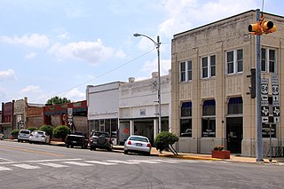
Downtown Martindale.
TXMap-doton-Martindale.PNG
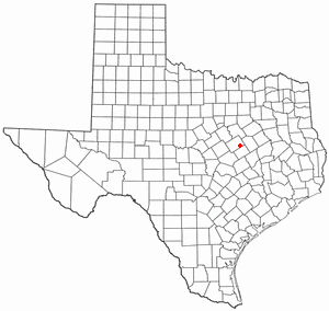
Location of Martindale, Texas
Caldwell County Martindale.svg
Coordinates: 29°50′55″N97°50′49″W / 29.84861°N 97.84694°W / 29.84861; -97.84694
Country United States
State Texas
County Caldwell
Area
[1]
  Total2.09 sq mi (5.42 km2)
  Land2.06 sq mi (5.34 km2)
  Water0.03 sq mi (0.07 km2)
Elevation
525 ft (160 m)
Population
 (2020)
  Total1,253
  Density596.70/sq mi (230.35/km2)
Time zone UTC-6 (Central (CST))
  Summer (DST) UTC-5 (CDT)
ZIP code
78655
Area code 512
FIPS code 48-46848 [2]
GNIS feature ID1362235 [3]
Website http://www.martindale.texas.gov/

Martindale is a city in Caldwell County, Texas, United States. It is part of the Austin metropolitan area. The population was 1,253 at the 2020 census.

Contents

The city hosts an egg hunt each Easter. Every Fourth of July, the town holds an Independence Parade leading to a town picnic at the oak-shaded river bottom.

In recent years, Martindale has also attracted a surprising number of film scouts that have been attracted to the town's turn-of-the-century charm. As a result, various television shows, music videos and movies have been filmed in town most notably: A Perfect World, starring Clint Eastwood and Kevin Costner; The Newton Boys, starring Matthew McConaughey and Ethan Hawke; and New Line's 2003 remake of The Texas Chainsaw Massacre. Over the years, each subsequent film crew has left its mark on the town. A strand of wood beams sits on a vacant lot next to the bank—all that remains of a saloon that was constructed for one of the westerns.

In 2004, Carlton Carl, a Washington D.C. lobbyist, purchased 36,000 square feet (3,300 m2) of commercial property in downtown Martindale. A partial inventory of Carl's purchase includes three empty general stores, a former bank, a cotton-seed weigh station, several warehouses, a movie-set courtroom, an aquarium filled with cotton plants, a seed elevator, 16 seed silos and 300 feet (91 m) of frontage on the San Marcos River. Carl has been working closely with the residents of Martindale to plan the next phase of the town's rejuvenation.

Model of the town Martindale after the proposed renovation by students at Texas State University. Martindale Model.JPG
Model of the town Martindale after the proposed renovation by students at Texas State University.

In Fall 2007, Carl worked with students at Texas State University of San Marcos in the Interior Design program, under the guidance of Assistant Professor and Program Coordinator Nancy Granato, to receive help envisioning further planning of the town. The project entailed assigning each group of students a specific building (i.e. silos, weigh station, etc.) to redesign the interior of and to think of a possible business that would work well with the space. One group worked on the landscape plan of the town in relation to planting native species of trees and plants, creating a city park, putting in new sidewalks and outdoor lighting. The ideas were then presented to Carl as well as some of the residents and leaders of the town. [4] Students in the MBA program, under the guidance of Associate Professor Bob Hill, also presented Carl with a market analysis for the town of Martindale, TX. The presentation included an examination of the business district and potential economic opportunities; analysis of economic trends and activities to drive growth; and the identification new retail and restaurant opportunities. [5]

History

Martindale was established in 1855 by Nancy Martindale, who moved to Texas from Mississippi in 1851 and donated land for the townsite.

John Crayton, his son James Lasater Crayton and their slaves moved to the banks of the San Marcos River in what is now downtown Martindale in 1839. On January 8, 1852, John Crayton sold the land to George Martindale that Nancy Martindale later donated for the town of Martindale. John Crayton moved to the Republic of Texas from Marion County Alabama but was born and married in Franklin County, Tennessee. He also donated the land for the Martindale City Cemetery. John Crayton lived in Martindale until his death in 1873.

Martindale Baptist church was organized in 1858, and a post office was established in 1875, when the local population was less than fifty. In 1890 the town had four general stores and four gristmills and gins. By 1892 the population was 200. In 1905, Martindale had two schools with four teachers and 184 white students and one school with one teacher for 73 black students. Four churches, a hotel, three cotton gins, three stores, a bank, and telephone service were in operation by 1914. Twenty Martindale businesses served residents in 1931.

From 1910 to 1946, the population was 500. In 1949, cottonseed and hybrid seed corn companies near Martindale, including the legendary Harper Seed Farm, supplied over 65 percent of the hybrid seed corn and a large percentage of the pedigreed cottonseed produced in Texas. The population of Martindale reached a high of 600 in 1957 but subsequently fell to 250 in 1969 and 210 in 1982, when only three businesses were active. In 1982, the town became the third in the county to incorporate. Immaculate Heart of Mary Catholic Church, built in 1908, was renovated by the parishioners' own labor in the mid-1980s and then was burned by an arsonist in 1991. After 1984, the local population increased, reaching 1,068 in 1988, when eleven businesses were in operation.

Demographics

Historical population
CensusPop.Note
1990 904
2000 9535.4%
2010 1,11617.1%
2020 1,25312.3%
U.S. Decennial Census [6]
Martindale racial composition as of 2020 [7]
(NH = Non-Hispanic) [lower-alpha 1]
RaceNumberPercentage
White (NH)45736.47%
Black or African American (NH)211.68%
Native American or Alaska Native (NH)50.4%
Some Other Race (NH)50.4%
Mixed/Multi-Racial (NH)403.19%
Hispanic or Latino 72557.86%
Total1,253

As of the 2020 United States census, there were 1,253 people, 431 households, and 275 families residing in the city.

As of the census [2] of 2000, there were 953 people, 332 households, and 234 families residing in the city. The population density was 472.4 inhabitants per square mile (182.4/km2). There were 363 housing units at an average density of 179.9 per square mile (69.5/km2). The racial makeup of the city was 58.76% White, 3.04% African American, 0.31% Native American, 33.79% from other races, and 4.09% from two or more races. Hispanic or Latino of any race were 61.49% of the population.

There were 332 households, out of which 31.9% had children under the age of 18 living with them, 52.7% were married couples living together, 12.3% had a female householder with no husband present, and 29.5% were non-families. 24.7% of all households were made up of individuals, and 6.0% had someone living alone who was 65 years of age or older. The average household size was 2.87 and the average family size was 3.49.

In the city, the population was spread out, with 26.5% under the age of 18, 13.2% from 18 to 24, 27.4% from 25 to 44, 21.8% from 45 to 64, and 11.0% who were 65 years of age or older. The median age was 33 years. For every 100 females, there were 99.0 males. For every 100 females age 18 and over, there were 96.6 males.

The median income for a household in the city was $33,882, and the median income for a family was $37,125. Males had a median income of $31,094 versus $20,625 for females. The per capita income for the city was $13,913. About 10.0% of families and 12.0% of the population were below the poverty line, including 11.6% of those under age 18 and 11.7% of those age 65 or over.

Education

The City of Martindale is served by the San Marcos Consolidated Independent School District. Hope Christian Academy is a private school run in Martindale for students ages preschool to middle school and is a ministry of Martindale Baptist Church.

Related Research Articles

<span class="mw-page-title-main">Uniontown, Alabama</span> City in Alabama, United States

Uniontown is a city in Perry County, Alabama, in west-central Alabama. As of the 2020 census, the population of the city is 2,107, up 18.7% over 2010. Of the 573 cities in Alabama, Uniontown is the 207th most populous.

<span class="mw-page-title-main">Sealy, Texas</span> City in Texas, United States

Sealy is a city in Austin County in southeastern Texas, United States. The population was 6,839 at the 2020 census. Sealy is located 49 miles (79 km) west of the downtown Houston area, on the most eastern part of the Texas-German belt region, an area settled by German emigrants.

<span class="mw-page-title-main">Somerset, Texas</span> City in Texas, United States

Somerset is a city located in Bexar County, Texas, United States. It is located less than 20 miles south of Downtown San Antonio and is part of the San Antonio–New Braunfels metropolitan area. The population was 1,756 at the 2020 census.

<span class="mw-page-title-main">Brazoria, Texas</span> City in Texas, United States

Brazoria is a city in the U.S. state of Texas, in the Houston–The Woodlands–Sugar Land metropolitan area and Brazoria County. As of the 2020 U.S. Census, the city population was 2,866.

<span class="mw-page-title-main">Bertram, Texas</span> City in Texas, United States

Bertram is a city in Burnet County, Texas, United States. The population was 1,353 at the 2010 census.

<span class="mw-page-title-main">Santa Anna, Texas</span> Town in Texas, United States

Santa Anna is a town in Coleman County in Central Texas, United States. Its population was 1,099 at the 2010 census.

<span class="mw-page-title-main">Valley View, Texas</span> City in Texas, United States

Valley View is a city in Cooke County, Texas, United States. Its population was 757 at the 2010 census.

<span class="mw-page-title-main">Roby, Texas</span> City in Texas, United States

Roby is a city in and the county seat of Fisher County, Texas, United States. The population was 643 at the 2010 census.

<span class="mw-page-title-main">Idalou, Texas</span> City in Texas, United States

Idalou is a city in Lubbock County, Texas, United States. It is located 7 miles (11 km) northeast of Lubbock near the intersection of Farm to Market Road 400 and US 62/US 82/SH 114. The population was 2,250 at the 2010 census. It is part of the Lubbock Metropolitan Statistical Area.

<span class="mw-page-title-main">Shallowater, Texas</span> Community in Texas, United States

Shallowater is a city in Lubbock County, Texas, United States. Shallowater is on U.S. Route 84 and the Burlington Northern Santa Fe line, 12 miles (19 km) northwest of Lubbock. Its population was 2,484 at the 2010 census. It is part of the Lubbock metropolitan statistical area.

<span class="mw-page-title-main">Brady, Texas</span> City in Texas, United States

Brady is a city in McCulloch County, Texas, United States. Brady refers to itself as the "Heart of Texas", as it is the city closest to the geographical center of the state, which is about 15 miles northeast of Brady. Its population was 5,528 at the 2010 census. It is the county seat of McCulloch County.

<span class="mw-page-title-main">Crawford, Texas</span> Town in Texas, United States

Crawford is a town located in western McLennan County, Texas, United States.

<span class="mw-page-title-main">Kerens, Texas</span> City in Texas, United States

Kerens is a city in Navarro County, Texas, United States. The population was 1,573 at the 2010 census.

<span class="mw-page-title-main">Bovina, Texas</span> City in Texas, United States

Bovina is a city in Parmer County, Texas, United States. The population was 1,868 at the 2010 census.

<span class="mw-page-title-main">Bremond, Texas</span> City in Texas, United States

Bremond is a city in Robertson County, Texas, United States. The population was 858 at the 2020 census.

<span class="mw-page-title-main">Impact, Texas</span> Town in Texas, United States

Impact is a town in Taylor County, Texas, United States. The population was 35 at the 2010 census. It is part of the Abilene, Texas Metropolitan Statistical Area.

<span class="mw-page-title-main">Poth, Texas</span> Town in Texas, United States

Poth is a town in Wilson County, Texas, United States. The population was 1,819 at the 2020 census. It is part of the San Antonio metropolitan area.

<span class="mw-page-title-main">Royse City, Texas</span> City in Texas, United States

Royse City is a city in Rockwall County in the U.S. state of Texas. It also extends into Collin and Hunt counties. The population was 2,957 at the 2000 census, rising to 9,349 in 2010. The estimated population in 2018 was 12,998. In 2020, its population grew to 13,508.

<span class="mw-page-title-main">Yoakum, Texas</span> City in Texas, United States

Yoakum is a city in Lavaca and DeWitt counties in the U.S. state of Texas. The population was 5,908 at the 2020 census.

<span class="mw-page-title-main">Hamlin, Texas</span> City in Texas, United States

Hamlin is a city in Jones and Fisher Counties in the U.S. state of Texas. The population was 2,124 at the 2010 census, and in 2018, the estimated population was 1,997. The Jones County portion of Hamlin is part of the Abilene, Texas metropolitan area.

References

  1. "2019 U.S. Gazetteer Files". United States Census Bureau. Retrieved August 7, 2020.
  2. 1 2 "U.S. Census website". United States Census Bureau . Retrieved 2008-01-31.
  3. "US Board on Geographic Names". United States Geological Survey. 2007-10-25. Retrieved 2008-01-31.
  4. Speir, Marc (2007). "Students Draw Plans to Renovate Martindale". Hillviews. Archived from the original on 2010-06-09. Retrieved 2010-06-26.
  5. Chamblee, M (2007)
  6. "Census of Population and Housing". Census.gov. Retrieved June 4, 2015.
  7. "Explore Census Data". data.census.gov. Retrieved 2022-05-24.
  8. https://www.census.gov/ [ not specific enough to verify ]
  9. "About the Hispanic Population and its Origin". www.census.gov. Retrieved 18 May 2022.
  1. Note: the US Census treats Hispanic/Latino as an ethnic category. This table excludes Latinos from the racial categories and assigns them to a separate category. Hispanics/Latinos can be of any race. [8] [9]