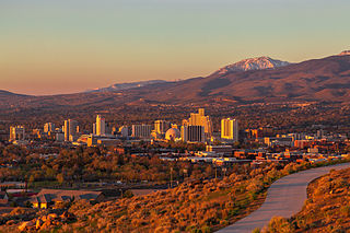
Reno is a city in the northwest section of the U.S. state of Nevada, along the Nevada-California border, about 22 miles (35 km) north from Lake Tahoe, known as "The Biggest Little City in the World". Known for its casino and tourism industry, Reno is the county seat and most populous city of Washoe County and sits in the High Eastern Sierra foothills, in the Truckee River valley, on the eastern side of the Sierra Nevada. The Reno metro area occupies a valley colloquially known as the Truckee Meadows, it is the 81st most populous city in the United States.

Lake Tahoe is a freshwater lake in the Sierra Nevada of the Western United States, straddling the border between California and Nevada. Lying at 6,225 ft (1,897 m) above sea level, Lake Tahoe is the largest alpine lake in North America, and at 122,160,280 acre⋅ft (150.7 km3) it trails only the five Great Lakes as the largest by volume in the United States. Its depth is 1,645 ft (501 m), making it the second deepest in the United States after Crater Lake in Oregon.

The Truckee River is a river in the U.S. states of California and Nevada. The river flows northeasterly and is 121 miles (195 km) long. The Truckee is the sole outlet of Lake Tahoe and drains part of the high Sierra Nevada, emptying into Pyramid Lake in the Great Basin. Its waters are an important source of irrigation along its valley and adjacent valleys.

Alpine Meadows is an unincorporated community in Placer County, California. The community is located on Bear Creek, a tributary of the Truckee River 5 miles (8.0 km) west of Tahoe City, at an elevation of 6,480 ft (1,980 m).
The Washoe or Wašišiw are a Great Basin tribe of Native Americans, living near Lake Tahoe at the border between California and Nevada. The name "Washoe" or "Washo" is derived from the autonym Waashiw in the Washo language or from Wašišiw (waší:šiw), the plural form of wašiw.

Washo is an endangered Native American language isolate spoken by the Washo on the California–Nevada border in the drainages of the Truckee and Carson Rivers, especially around Lake Tahoe. While there are only 20 elderly native speakers of Washo, since 1994 there has been a small immersion school that has produced a number of moderately fluent younger speakers. The immersion school has since closed its doors and the language program now operates through the Cultural Resource Department for the Washoe Tribe. The language is still very much endangered; however, there has been a renaissance in the language revitalization movement as many of the students who attended the original immersion school have become teachers.

The Indigenous peoples of the Great Basin are Native Americans of the northern Great Basin, Snake River Plain, and upper Colorado River basin. The "Great Basin" is a cultural classification of indigenous peoples of the Americas and a cultural region located between the Rocky Mountains and the Sierra Nevada, in what is now Nevada, and parts of Oregon, California, Idaho, Wyoming, and Utah. The Great Basin region at the time of European contact was ~400,000 sq mi (1,000,000 km2). There is very little precipitation in the Great Basin area which affects the lifestyles and cultures of the inhabitants.

Palisades Tahoe is a ski resort in the western United States, located in Olympic Valley, California, northwest of Tahoe City in the Sierra Nevada range. From its founding in 1949, the resort was known as Squaw Valley, but it changed its name in 2021 due to the derogatory connotations of the word "squaw". It was the host site for the 1960 Winter Olympics.
The Truckee Meadows is a valley in Northern Nevada, named for the Truckee River, which collects and drains all water in the valley. Truckee Meadows is also colloquially used as a name for the Reno–Tahoe-Fernley CSA area, even though the metro area includes areas outside this valley. The name for the valley in the Washo language is Welganuk.

Indian Grinding Rock State Historic Park is a California State Park, preserving an outcropping of marbleized limestone with some 1,185 mortar holes—the largest collection of bedrock mortars in North America. It is located in the Sierra Nevada foothills, 8 miles (13 km) east of Jackson. The park is nestled in a little valley 2,400 feet (732 m) above sea level, with open meadows and large specimens of valley oak that once provided the Miwok peoples of this area with an ample supply of acorns. The 135-acre (55 ha) park was established in 1962 and listed on the National Register of Historic Places in 1971.
The Timbisha are a Native American tribe federally recognized as the Death Valley Timbisha Shoshone Band of California. They are known as the Timbisha Shoshone Tribe and are located in south central California, near the Nevada border. As of the 2010 Census the population of the Village was 124. The older members still speak the ancestral language, also called Timbisha.
Washoe traditional narratives include myths, legends, tales, and oral histories preserved by the Washoe people of the Lake Tahoe and surrounding Sierra Nevada area of eastern California and western Nevada.

State Route 431, commonly known as the Mount Rose Highway, is a 24.413-mile-long (39.289 km) highway in Washoe County, Nevada, that connects Incline Village at Lake Tahoe with Reno. The highway, a Nevada Scenic Byway, takes its name from Mount Rose, which lies just off the highway. Prior to 1976, the highway existed as State Route 27.

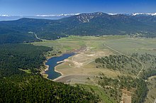
Mount Rose is the highest mountain in Washoe County, within the Carson Range of Nevada, United States. It ranks thirty-seventh among the most topographically prominent peaks in the state. It is also both the highest and most topographically prominent peak of the greater Sierra Nevada range within the state of Nevada, and the third most topographically prominent peak in the Sierra Nevada overall. It is located in the Mount Rose Wilderness of the Humboldt-Toiyabe National Forest. An extinct volcano, the mountain is in between Lake Tahoe and Reno. State Route 431 traverses Mount Rose Summit southeast of Mount Rose. Due to the high elevation, most of the precipitation that falls on the mountain is snow. The view from Mount Rose facing east is the Truckee Meadows, the second largest population center in Nevada.
French Lake, California located in Nevada County, was a California Gold Rush community, now uninhabited. It was located by a lake of the same name.

The Washoe Tribe of Nevada and California are a federally recognized tribe of Washoe Indians, living in California and Nevada. They are several communities south and east of Lake Tahoe united under a tribal council. The tribe owns over 64,300 acres (26,000 ha) in different parcels.

Martis Valley is a geographic area of 70 square miles (180 km2) in the United States, extending northward from the North Shore of Lake Tahoe, California, to the west of the California-Nevada border. It is located in Placer and Nevada Counties and is bisected by Martis Creek which flows north to the Truckee River.

Martis Creek is a northward-flowing stream originating on Sawtooth Ridge, west of the peak of Mount Pluto in Placer County, California, United States. After crossing into Nevada County, California, it is tributary to the Truckee River on the eastern side of Truckee.

The Truckee Meadows Fire Protection District of Washoe County Nevada covers the eastern slopes of the Sierra Nevada Mountains in Western Nevada. The county spans an area of nearly 6,600 square miles in the northwest section of the state bordering California and Oregon. TMFPD was originally founded in 1972 and operated independently until 2001. Washoe County contracted the City of Reno Fire Dept. to operate TMFPD engines until 2012. Early in 2012 the agreement with the City of Reno was terminated and TMFPD was stood back up and operated independently again. The Truckee Meadows Fire Protection District operates a fire apparatus fleet of 10 engines, 1 ladder company, 11 brush trucks, 1 rescue squad, 1 ambulance, 1 hazardous material unit, various support units, 2 technical rescue support units, 9 water tenders, and 2 water rescue entry vehicles The District's primary areas of responsibility include rural and suburban communities outside the City of Reno. Truckee Meadows Fire Protection District responded to 10,581 calls for service with a 2017/2018 budget of $27,932,275.