Masurica

Last updated
Masurica
Village
Masuritsa (osnovna shkola i seoski dom) - Masurica - Masurica (School and Community House).jpg
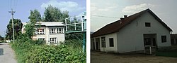
School and Community House in Masurica
CountryFlag of Serbia.svg  Serbia
District Pčinja District
Municipality Surdulica
Population
 (2002)
  Total1,245
Time zone UTC+1 (CET)
  Summer (DST) UTC+2 (CEST)

Masurica is a village in the municipality of Surdulica, Serbia. According to the 2002 census, the village has a population of 1245 people. [1]

Related Research Articles

Batken Region Region of Kyrgyzstan

Batken Region is a region (oblus) of Kyrgyzstan. Its capital is Batken. It is bounded on the east by Osh Region, on the south, west and north by Tajikistan, and on the northeast by Uzbekistan. The northern part of the region is part of the flat, agricultural Ferghana Valley. The land rises southward to the mountains on the southern border: the Alay Mountains in the east, and the Turkestan Range in the west. Its total area is 17,048 km2 (6,582 sq mi). The resident population of the region was 548,247 as of January 2021. The region has sizeable Uzbek and Tajik minorities.

Jeníkovice (Pardubice District)

Jeníkovice is a village in the Pardubice Region of the Czech Republic. It has around 230 inhabitants.

Daugherty is an unincorporated community in Accomack County, Virginia, United States.

Zawady, Gmina Zawady Village in Podlaskie Voivodeship, Poland

Zawady is a village in Białystok County, Podlaskie Voivodeship, in north-eastern Poland. It is the seat of the gmina called Gmina Zawady. It lies approximately 34 km (21 mi) west of the regional capital Białystok.

Siemień-Rowy is a village in the administrative district of Gmina Łomża, within Łomża County, Podlaskie Voivodeship, in north-eastern Poland.

Chmiel-Kolonia is a village in the administrative district of Gmina Jabłonna, within Lublin County, Lublin Voivodeship, in eastern Poland. It lies approximately 6 kilometres (4 mi) east of Jabłonna and 19 km (12 mi) south of the regional capital Lublin.

Żery-Czubiki is a village in the administrative district of Gmina Grodzisk, within Siemiatycze County, Podlaskie Voivodeship, in north-eastern Poland.

Klęczany is a village in the administrative district of Gmina Chełmiec, within Nowy Sącz County, Lesser Poland Voivodeship, in southern Poland. It lies approximately 5 kilometres (3 mi) north-west of Chełmiec, 7 km (4 mi) north-west of Nowy Sącz, and 67 km (42 mi) south-east of the regional capital Kraków.

Manasterz is a village in the administrative district of Gmina Wiązownica, within Jarosław County, Subcarpathian Voivodeship, in south-eastern Poland. It lies approximately 12 kilometres (7 mi) north of Jarosław and 49 km (30 mi) east of the regional capital Rzeszów.

Field Farm (Williamstown, Massachusetts)

Field Farm is a 316-acre (1.28 km2) nature preserve and farm in Williamstown, Massachusetts, managed by the Trustees of Reservations. There are 4.5 miles (7.2 km) of hiking trails on the reservation, which pass by swamp land, a pond, and the "Caves Lot" which features underground channels that water had cut into the limestone there. An International Style house, built in 1948 by Edwin Goodell, is operated as a bed and breakfast inn. Also on the site is The Folly, a small guest house designed by Ulrich Franzen in 1966. The Folly is currently open for guided tours. The property also contains a sculpture garden.

Pawłowice is a village in the administrative district of Gmina Mogielnica, within Grójec County, Masovian Voivodeship, in east-central Poland. It lies approximately 5 kilometres (3 mi) north-west of Mogielnica, 23 km (14 mi) south-west of Grójec, and 62 km (39 mi) south of Warsaw.

Przymuszewo is a village in the administrative district of Gmina Brusy, within Chojnice County, Pomeranian Voivodeship, in northern Poland. It lies approximately 14 kilometres (9 mi) north of Brusy, 35 km (22 mi) north of Chojnice, and 76 km (47 mi) south-west of the regional capital Gdańsk.

Ojcowa Wola is a village in the administrative district of Gmina Młynary, within Elbląg County, Warmian-Masurian Voivodeship, in northern Poland. It lies approximately 3 kilometres (2 mi) south of Młynary, 22 km (14 mi) east of Elbląg, and 67 km (42 mi) north-west of the regional capital Olsztyn.

Samborowo is a village in the administrative district of Gmina Ostróda, within Ostróda County, Warmian-Masurian Voivodeship, in northern Poland. It lies approximately 11 kilometres (7 mi) west of Ostróda and 47 km (29 mi) west of the regional capital Olsztyn.

Sông Xoài Commune and village in Bà Rịa–Vũng Tàu, Vietnam

Sông Xoài is a commune (xã) and village in the district-level town of Phú Mỹ, Bà Rịa–Vũng Tàu province, in Vietnam.

Geography of Antigua and Barbuda

Antigua and Barbuda lie in the eastern arc of the Leeward Islands of the Lesser Antilles, separating the Atlantic Ocean from the Caribbean Sea. Antigua is 650 km (400 mi) southeast of Puerto Rico; Barbuda lies 48 km (30 mi) due north of Antigua, and the uninhabited island of Redonda is 56 km (35 mi) southwest of Antigua.

Pudivere is a village in Põltsamaa Parish, Jõgeva County in eastern Estonia.

Žiljevo is a village in the municipality of Nevesinje, Republika Srpska, Bosnia and Herzegovina.

Vukmanovac is a village in the municipality of Rekovac, Serbia. According to the 2002 census, the village has a population of 477 people.

Öküzlü Archaeological site in Mersin Province, Turkey

Öküzlü is an archaeological site in Mersin Province, Turkey.

References

  1. Popis stanovništva, domaćinstava i Stanova 2002. Knjiga 1: Nacionalna ili etnička pripadnost po naseljima. Republika Srbija, Republički zavod za statistiku Beograd 2003. ISBN   86-84433-00-9

Coordinates: 42°39′58″N22°09′39″E / 42.66611°N 22.16083°E / 42.66611; 22.16083