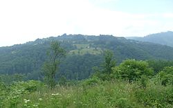
Trstena | |
---|---|
Village's landscape | |
Coordinates: 42°40′47″N21°46′07″E / 42.67972°N 21.76861°E Coordinates: 42°40′47″N21°46′07″E / 42.67972°N 21.76861°E | |
Country | Serbia |
District | Pčinja District |
Municipality | Vranje |
Area | |
• Total | 15.29 km2 (5.90 sq mi) |
Elevation | 823 m (2,700 ft) |
Population (2011) [2] | |
• Total | 43 |
• Density | 2.8/km2 (7.3/sq mi) |
Time zone | UTC+1 (CET) |
• Summer (DST) | UTC+2 (CEST) |
Trstena is a village located in the municipality of Vranje, Serbia. According to the 2011 census, the village has a population of 43 people. [2]
Sopot is a municipality of the city of Belgrade. According to the 2011 census results, the town has a population of 4,548 inhabitants while the municipality has 20,367 inhabitants. Sopot is located near the mountain Kosmaj.
Bujanovac is a town and municipality located in the Pčinja District of southern Serbia. Situated in the South Morava basin, it is located in the geographical area known as Preševo Valley. It is also known for its source of mineral water and spa town Bujanovačka banja.
Vladimirci is a village and municipality located in the Mačva District of western Serbia. According to the 2011 census results, the population of the village is 1,662, while population of the municipality is 17,462.
Sjenica is a town and municipality located in the Zlatibor District of southwestern Serbia. The population of the town, according to 2011 census, is 14,060 inhabitants, while the municipality has 26,392.
Raška is a town and municipality located in the Raška District of southwestern Serbia. The municipality has a population of 24,680 people, while the town has a population of 6,574 people. It covers an area of 670 km². The town is situated on the rivers Raška and Ibar.
Koceljeva is a village and municipality located in the Mačva District of western Serbia. According to the 2011 census results, the population of the village is 4,182, while population of the municipality is 13,129.
Osečina is a town and municipality located in the Kolubara District of western Serbia. As of 2011, the population of the town is 2,730, while population of the municipality is 12,571 inhabitants.
Lučani is a town and municipality located in the Moravica District of western Serbia. The population of the town is 5,142, while the population of the municipality is 20,897.
Knić is a village and municipality located in the Šumadija District of central Serbia. According to 2011 census, the population of the town is 2,166, while population of the municipality is 14,237.
Merošina is a village and municipality located in the Nišava District of the southern Serbia. According to 2011 census, the municipality has 13,968 inhabitants, from which 905 live in Merošina itself.
Doljevac is a small town and municipality located in the Nišava District of the southern Serbia. According to 2011 census, the municipality has 18,463 inhabitants, while the village has 1,657.
Babušnica is a town and municipality located in the Pirot District of south|eastern Serbia. According to 2011 census, the population of the town is 4,601, while population of the municipality is 12,307.
Zaovine is a village located in the municipality of Bajina Bašta, Serbia. According to the 2011 census, the village has a population of 263 inhabitants. The whole territory of the village is a part of the Tara National park and is in close proximity of the Zaovine Lake.
Lukovo is a village on the eastern slopes of Mount Kopaonik, in the municipality of Kuršumlija, in southern Serbia. It is a spa town of highest altitude in Serbia. According to the 2011 census, the village has a population of 275 inhabitants.
Merdare is a village located in the municipality of Kuršumlija, Serbia. According to the 2011 census, the village has a population of 151 people. The administrative crossing between Central Serbia and Kosovo is located in Merdare.
Petrovo Selo is a village in the municipality of Kladovo, Serbia. According to the 2011 census results, the village has a population of 79 inhabitants.
Kušići is a village located in the municipality of Ivanjica, southwestern Serbia. It is situated on the slopes of the Javor mountain, about 25 kilometres (16 mi) from Ivanjica and 220 kilometres (140 mi) from Belgrade and is 990m above sea level. According to the 2011 census, the village has a population of 498 inhabitants.
Opaljenik is a village located in the municipality of Ivanjica, southwestern Serbia. According to the 2011 census, the village has a population of 219 inhabitants.
Prilike is a village located in the municipality of Ivanjica, Serbia. According to the 2011 census, the village has a population of 1,311 inhabitants.
Prosek is a village in the municipality of Niška Banja, within the city of Niš, Serbia. According to the 2011 census, the village had 599 inhabitants.