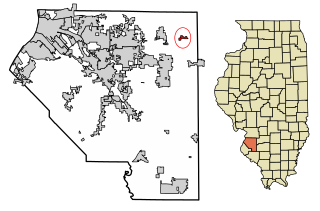
Summerfield is a village in St. Clair County, Illinois, United States. The population was 451 at the 2010 census.
Zalduondo is a village and municipality located in the province of Araba (Álava), in the Basque Country, northern Spain. In 2012 the population was 185 persons and the extension of the village is 12,03 km².

Wisconsin's 2nd congressional district is a congressional district of the United States House of Representatives in southern Wisconsin, covering Dane County, Iowa County, Lafayette County, Sauk County and Green County, as well as portions of Richland County and Rock County. The district includes Madison, the state's capital, its suburbs and some of the surrounding areas.
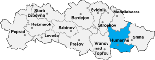
Brestov is a village and municipality in Humenné District in the Prešov Region of north-east Slovakia. The mayor is Ľudmila Nováková (Independent).
Blizne Ukrainian: Близне, Blyzne is a village in the administrative district of Gmina Jasienica Rosielna, within Brzozów County, Subcarpathian Voivodeship, in south-eastern Poland. It lies approximately 3 kilometres (2 mi) east of Jasienica Rosielna, 7 km (4 mi) north-west of Brzozów, and 32 km (20 mi) south of the regional capital Rzeszów. The village has a population of 2,800.
Lyons is an unincorporated community located near the Kansas City Southern rail line in Adair County, Oklahoma, United States.

Hanchey Army Heliport is a military heliport serving Fort Rucker in Dale County, Alabama, United States. Owned by the United States Army, it is located 6 NM (11 km) south of the city of Ozark.

Malice is a village in the administrative district of Gmina Werbkowice, within Hrubieszów County, Lublin Voivodeship, in eastern Poland. It lies approximately 5 kilometres (3 mi) south-west of Werbkowice, 15 km (9 mi) south-west of Hrubieszów, and 102 km (63 mi) south-east of the regional capital Lublin.
Złotoria-Podlesie is a village in the administrative district of Gmina Choroszcz, within Białystok County, Podlaskie Voivodeship, in north-eastern Poland.
Kuczków is a village in the administrative district of Gmina Secemin, within Włoszczowa County, Świętokrzyskie Voivodeship, in south-central Poland. It lies approximately 8 kilometres (5 mi) south-west of Secemin, 21 km (13 mi) south-west of Włoszczowa, and 64 km (40 mi) west of the regional capital Kielce.
Ksawerynów is a village in the administrative district of Gmina Łaskarzew, within Garwolin County, Masovian Voivodeship, in east-central Poland.
Zalesie is a village in the administrative district of Gmina Chynów, within Grójec County, Masovian Voivodeship, in east-central Poland. It lies approximately 6 kilometres (4 mi) south-east of Chynów, 20 km (12 mi) east of Grójec, and 39 km (24 mi) south of Warsaw.
Lubnica is a village in the administrative district of Gmina Okonek, within Złotów County, Greater Poland Voivodeship, in west-central Poland. It lies approximately 12 kilometres (7 mi) north of Okonek, 33 km (21 mi) north of Złotów, and 138 km (86 mi) north of the regional capital Poznań.
Kawcze is a village in Gmina Miastko, Bytów County, Pomeranian Voivodeship, in northern Poland. It lies approximately 41 kilometres (25 mi) south-west of Bytów and 119 km (74 mi) south-west of Gdańsk.
Ostrowite is a village in the administrative district of Gmina Czersk, within Chojnice County, Pomeranian Voivodeship, in northern Poland. It lies approximately 6 kilometres (4 mi) south-east of Czersk, 33 km (21 mi) east of Chojnice, and 79 km (49 mi) south-west of the regional capital Gdańsk.
Pole Rakowieckie is a village in the administrative district of Gmina Kwidzyn, within Kwidzyn County, Pomeranian Voivodeship, in northern Poland. It lies approximately 7 kilometres (4 mi) east of Kwidzyn and 74 km (46 mi) south of the regional capital Gdańsk.
Zębowo is a village in the administrative district of Gmina Kobylnica, within Słupsk County, Pomeranian Voivodeship, in northern Poland. It lies approximately 8 kilometres (5 mi) west of Kobylnica, 10 km (6 mi) west of Słupsk, and 114 km (71 mi) west of the regional capital Gdańsk.

Rujkovac is a village in the municipality of Medveđa, Serbia. According to the 2002 census, the village has a population of 267 people.
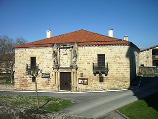
Guereña is a village in Álava, Basque Country, Spain.
Kurtkulağı is a village in the District of Ceyhan, Adana Province, Turkey. Kurtkulağı Kervansarayı is in the village. There also is a mosque nearby, both stem from the time the Silk Road passed through this village.
