Max Meadows, Virginia

Last updated
Max Meadows, Virginia
CDP
VAMap-doton-MaxMeadows.PNG
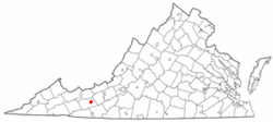
Location of Max Meadows, Virginia
Coordinates: 36°58′18″N80°57′18″W / 36.97167°N 80.95500°W / 36.97167; -80.95500 Coordinates: 36°58′18″N80°57′18″W / 36.97167°N 80.95500°W / 36.97167; -80.95500
CountryUnited States
State Virginia
County Wythe
Area
  Total4.7 sq mi (12.1 km2)
  Land4.7 sq mi (12.1 km2)
  Water0.0 sq mi (0.0 km2)
Elevation
2,028 ft (618 m)
Population
 (2010)
  Total562
  Density120/sq mi (46/km2)
Time zone UTC−5 (Eastern (EST))
  Summer (DST) UTC−4 (EDT)
ZIP code
24360
Area code(s) 276
FIPS code 51-50312 [1]
GNIS feature ID1485232 [2]

Max Meadows is a census-designated place (CDP) in Wythe County, Virginia, United States. The population was 562 at the 2010 census.

Contents

History

The Foster Falls Historic District, Graham's Forge Mill, Sanders Farm, and Jackson Ferry Shot Tower are listed on the National Register of Historic Places. [3]

Geography

Max Meadows is located at 36°58′18″N80°57′18″W / 36.97167°N 80.95500°W / 36.97167; -80.95500 (36.971634, 80.954886). [4]

According to the United States Census Bureau, the CDP has a total area of 4.7 square miles (12.1 km2), all land.

Demographics

As of the census [1] of 2000, there were 512 people, 206 households, and 154 families residing in the CDP. The population density was 109.8 people per square mile (42.4/km2). There were 235 housing units at an average density of 50.4/sq mi (19.5/km2). The racial makeup of the CDP was 93.16% White, 3.91% African American, 0.20% Native American, 0.39% Asian, 1.37% from other races, and 0.98% from two or more races. Hispanic or Latino of any race were 1.56% of the population.

There were 206 households, out of which 27.2% had children under the age of 18 living with them, 55.3% were married couples living together, 13.1% had a female householder with no husband present, and 25.2% were non-families. 23.3% of all households were made up of individuals, and 10.7% had someone living alone who was 65 years of age or older. The average household size was 2.49 and the average family size was 2.91.

In the CDP, the population was spread out, with 19.9% under the age of 18, 10.5% from 18 to 24, 26.0% from 25 to 44, 27.7% from 45 to 64, and 15.8% who were 65 years of age or older. The median age was 41 years. For every 100 females, there were 88.9 males. For every 100 females age 18 and over, there were 91.6 males.

The median income for a household in the CDP was $22,300, and the median income for a family was $36,705. Males had a median income of $30,156 versus $20,398 for females. The per capita income for the CDP was $14,757. About 11.7% of families and 12.7% of the population were below the poverty line, including 18.0% of those under age 18 and none of those age 65 or over.

Notable people

Related Research Articles

Selmont-West Selmont, Alabama Census-designated place in Alabama, United States

Selmont-West Selmont is a census-designated place (CDP) in Dallas County, Alabama, United States. At the 2010 census the population was 2,671.

Naknek, Alaska CDP/borough seat in Alaska, United States

Naknek is a census-designated place located in and the borough seat of Bristol Bay Borough in the U.S. state of Alaska. As of the 2010 census, the population of the CDP was 544, down from 678 in 2000.

Roosevelt Gardens is a census-designated place (CDP) in Broward County, Florida, United States. The population was 2,456 at the 2010 census.

Sunset, Florida CDP in Florida, United States

Sunset is a census-designated place (CDP) and affluent neighborhood in Miami-Dade County, Florida, United States. The population was 16,389 at the 2010 census. The zip-codes serving Sunset are 33173, 33183, and 33193.

High Point was a census-designated place (CDP) in Palm Beach County, Florida, United States. The population was 2,191 at the 2000 census. The CDP was removed from the 2010 census. Although it is still unincorporated, it is within Delray Beach's "future annexation area."

Schall Circle is a census-designated place (CDP) in Palm Beach County, Florida, United States. The population was 965 at the 2000 census.

Seminole Manor is a census-designated place (CDP) in Palm Beach County, Florida, United States. The population was 2,546 at the 2000 census. The neighborhood was developed in the late 1950s, with the majority of houses built in 1958 and 1959.

Lydia, Louisiana Census-designated place in Louisiana, United States

Lydia is an unincorporated community and census-designated place (CDP) in Iberia Parish, Louisiana, United States. The population was 952 at the 2010 census, down from 1,079 at the 2000 census. It is part of the New Iberia Micropolitan Statistical Area.

St. Augustine South, Florida CDP in Florida, United States

St. Augustine South is a census-designated place (CDP) in St. Johns County, Florida, United States. The population was 5,035 at the 2000 census.

Churchill, Ohio CDP in Ohio, United States

Churchill is a census-designated place (CDP) in Liberty Township, Trumbull County, Ohio, United States. The population was 2,601 at the 2000 census. It is part of the Youngstown–Warren–Boardman, OH-PA Metropolitan Statistical Area.

Maplewood Park, Ohio CDP in Ohio, United States

Maplewood Park is a census-designated place (CDP) in Trumbull County, Ohio, United States. The population was 321 at the 2000 census. It is part of the Youngstown–Warren–Boardman, OH-PA Metropolitan Statistical Area.

Zena, Oklahoma CDP in Oklahoma, United States

Zena is a census-designated place (CDP) in Delaware County, Oklahoma, United States, along State Highway 127. The population was 122 at the 2010 census. Established on Courthouse Prairie in District 5 of the old Indian Territory, its post office existed from April 11, 1896, until January 31, 1956. It is said to have been named for Asenith Wood, the wife of the first postmaster.

Weigelstown, Pennsylvania CDP in Pennsylvania, United States

Weigelstown is a census-designated place (CDP) in York County, Pennsylvania, United States. The population was 12,875 at the 2010 census.

Belvedere, South Carolina Census-designated place in South Carolina, United States of America

Belvedere is a census-designated place (CDP) and suburb of North Augusta in Aiken County, South Carolina, United States. It is part of the Augusta, Georgia metropolitan area. The population was 5,792 at the 2010 census.

Edroy, Texas CDP in Texas, United States

Edroy is a census-designated place (CDP) in San Patricio County, Texas, United States. The population was 331 at the 2010 census.

Ferrum, Virginia CDP in Virginia, United States

Ferrum is a census-designated place (CDP) in Franklin County, Virginia, United States. The population was 2,043 at the 2010 census, an increase of over fifty percent from the 1,313 reported in 2000. Ferrum is home to Ferrum College and its Blue Ridge Folklife Festival. It is part of the Roanoke Metropolitan Statistical Area.

Atkins, Virginia CDP in Virginia, United States

Atkins is a census-designated place (CDP) in Smyth County, Virginia, United States. The population was 1,143 at the 2010 census.

Emory-Meadowview, Virginia former CDP in Virginia, United States

Emory-Meadowview was a census-designated place (CDP) in Washington County, Virginia, United States. The population was 2,266 at the 2000 census. It is part of the Kingsport–Bristol (TN)–Bristol (VA) Metropolitan Statistical Area, which is a component of the Johnson City–Kingsport–Bristol, TN-VA Combined Statistical Area – commonly known as the "Tri-Cities" region. As of the 2010 census it was split into Emory and Meadow View CDPs.

Tiawah, Oklahoma Census-designated place in Oklahoma, United States

Tiawah is a census-designated place (CDP) in Rogers County, Oklahoma, United States. The population was 189 at the 2010 census, a 13.9 percent gain over the figure of 166 recorded in 2000. It was built on the St. Louis, Iron Mountain, & Southern Railway line running from Coffeyville, Kansas, to Fort Smith, Arkansas. The post office existed from August 24, 1903, until December 31, 1938. It is said to be named for Tiawah Mound in Georgia.

Peñasco, New Mexico CDP in New Mexico, United States

Peñasco is a census-designated place (CDP) in Taos County, New Mexico. It is located along the scenic High Road to Taos. The population is estimated at about 1,200 (2015).

References

  1. 1 2 "U.S. Census website". United States Census Bureau . Retrieved 2008-01-31.
  2. "US Board on Geographic Names". United States Geological Survey. 2007-10-25. Retrieved 2008-01-31.
  3. "National Register Information System". National Register of Historic Places . National Park Service. July 9, 2010.
  4. "US Gazetteer files: 2010, 2000, and 1990". United States Census Bureau. 2011-02-12. Retrieved 2011-04-23.
  5. Myers, John. "Toni Atkins prepares to be first woman to have held the top job in both the California state Senate and Assembly". sandiegouniontribune.com. Retrieved 2018-03-22.