
McClellanville is a small fishing town in rural Charleston County, South Carolina, United States. The population was 605 at the 2020 census. It is situated on the Atlantic coast, on land surrounded by Francis Marion National Forest, and has traditionally derived its livelihood from the Atlantic Ocean and coastal marshes by fishing, shrimping and oystering. McClellanville is part of the Charleston-North Charleston-Summerville metropolitan area and the Charleston-North Charleston Urbanized Area.

St. James Church, Santee, also known as St. James Episcopal Church, Santee, is a historic church located in a remote portion of Francis Marion National Forest in Charleston County, South Carolina, United States. Built in 1768, it is a remarkably sophisticated expression of fashionable Georgian architecture in a remote area, and was designated a National Historic Landmark in 1970 for its architectural significance. It is located on the west side of the Old Georgetown Road, several miles north of South Carolina Highway 46 and McClellanville.

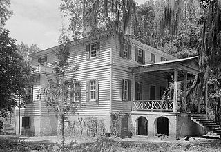
Hampton Plantation, also known as Hampton Plantation House and Hampton Plantation State Historic Site, is a historic plantation, now a state historic site, north of McClellanville, South Carolina. The plantation was established in 1735, and its main house exhibits one of the earliest known examples in the United States of a temple front in domestic architecture. It is also one of the state's finest examples of a wood frame Georgian plantation house. It was declared a National Historic Landmark in 1970.

St. Michael's AnglicanChurch is a historic church and the oldest surviving religious structure in Charleston, South Carolina. It is located at Broad and Meeting streets on one of the Four Corners of Law, and represents ecclesiastical law. It was built in the 1750s by order of the South Carolina Assembly. It is listed on the National Register of Historic Places and is a National Historic Landmark.
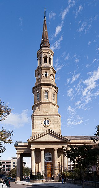
St. Philip's Church is an historic church at 142 Church Street in Charleston, South Carolina. Its National Historic Landmark description states: "Built in 1836, this stuccoed brick church features an imposing tower designed in the Wren-Gibbs tradition. Three Tuscan pedimented porticoes contribute to this design to make a building of the highest quality and sophistication." On November 7, 1973, it was added to the National Register of Historic Places and designated a National Historic Landmark.

This is a list of the National Register of Historic Places listings in Charleston County, South Carolina.

The Wedge Plantation, which is also known as The Wedge or the William Lucas House, is a plantation about 5 mi (8 km) east of McClellanville in Charleston County, South Carolina. The plantation is a wedge-shaped property between the Harrietta Plantation and the Fairfield Plantation. The plantation house was built around 1830. It is located off US Highway 17 near the Santee River. It was named to the National Register of Historic Places on September 18, 1975.

Harrieta Plantation is a plantation about 5 mi (8 km) east of McClellanville in Charleston County, South Carolina. It is located off US Highway 17 near the Santee River, adjacent to the Wedge Plantation and just south of Fairfield Plantation. The plantation house was built around 1807 and was named to the National Register of Historic Places on September 18, 1975.
Fairfield Plantation, also known as the Lynch House is a plantation about 5 mi (8 km) east of McClellanville in Charleston County, South Carolina. It is adjacent to the Wedge Plantation and just north of Harrietta Plantation. The plantation house was built around 1730. It is located just off US Highway 17 near the Santee River. It was named to the National Register of Historic Places on September 18, 1975.

The U.S. Post Office and Courthouse is a historic post office and courthouse located at Charleston in Charleston County, South Carolina. The building and its annexes serve the federal court for the Charleston Division of the United States District Court for the District of South Carolina. The building was listed on the National Register of Historic Places in 1974.

Bethel African Methodist Episcopal Church is a historic African Methodist Episcopal church located at 369 Drayton Street in McClellanville, South Carolina. It was built around 1872, and is a one-story, rectangular frame vernacular Gothic Revival church. It has a pedimented gable-front roof that supports a square-based steeple. A cemetery is on the property. It was added to the National Register of Historic Places in 2004.

John Henry Devereux, also called John Delorey before 1860, was an American architect and builder best known for his designs in Charleston, South Carolina. According to the National Park Service, he was the "most prolific architect of the post-Civil War era" in the Charleston area. His works are listed on the U.S. National Register of Historic Places. His Charleston Post Office and Courthouse has been designated as a U.S. National Historic Landmark.

Botany Bay Heritage Preserve & Wildlife Management Area is a state preserve on Edisto Island, South Carolina. Botany Bay Plantation was formed in the 1930s from the merger of the Colonial-era Sea Cloud Plantation and Bleak Hall Plantation. In 1977, it was bequeathed to the state as a wildlife preserve; it was opened to the public in 2008. The preserve includes a number of registered historic sites, including two listed in the National Register of Historic Places: a set of three surviving 1840s outbuildings from Bleak Hall Plantation, and the prehistoric Fig Island shell rings.

West End Commercial Historic District is a national historic district located at Greenville, South Carolina. It encompasses 15 contributing buildings in Greenville's second "downtown." The commercial buildings primarily date from about 1880 to 1920, and include examples of Victorian commercial architecture. Notable buildings include the American Bank, Alliance and Mills & McBayer Cotton Warehouses, Indian River Fruit Store, Pete's Place, Bacot's West End Drug Store/Stringer's Drug, Furman Lunch, and Greer Thompson Building.

Willtown Bluff, also known as Wilton and New London, is a historic settlement site located on the S. Edisto River near Adams Run, Charleston County, South Carolina. Founded about 1704, it was the second planned town to be established after the relocation of Charleston in 1682. Willtown served as a local governmental center and regional commercial center. The property includes three early-19th-century buildings: the Parsonage, the Willtown Plantation House, and the remains of a single column of the Episcopal Church. Unexposed remains are of a colonial village thought to have had 80 houses.

Moultrieville Historic District is a national historic district located at Sullivan's Island, Charleston County, South Carolina. The district encompasses 18 contributing buildings and 1 contributing site in Moultrieville. They predominantly include frame residences built between about 1830 to 1930 which are known as "Island Houses." Also located in the district are the Stella Maris Catholic Church (1869-1873) and Fort Moultrie Torpedo Shed/Mines Storehouse.

Graham Historic District is a national historic district located at Graham, Alamance County, North Carolina. It encompasses 72 contributing buildings and 1 contributing structure in the central business district of Graham. The district includes a variety of institutional, commercial, and residential buildings largely dating from the 19th century. Notable buildings include the Alamance County Courthouse, the centerpiece of the district; Graham Presbyterian Church; Harden House; Hunter House; Nicks Store; McBride Holt House ; Scott Building ; Vestal Hotel; Holt-Scott General·Store ; National Bank of Alamance ; Mont-White Theatre; and Paris Building.

Southport Historic District is a national historic district located at Southport, Brunswick County, North Carolina. The district encompasses 161 contributing buildings, 3 contributing sites, and 1 contributing object. Over half of the structures in the historic district date from the 1885-1905 period. It includes residential, commercial, and institutional buildings and is considered the best example of a Victorian coastal town in North Carolina. Notable buildings include the River Pilots Tower and Building (1940s), Frying Pan Lightship, Fort Johnston Officers Quarters, Walker-Pike House, Brunswick Inn, Fort Johnston Hospital, Former Brunswick County Court House, Saint Philips Episcopal Church, Trinity Methodist Church (1888-1890), and the Adkins-Ruark House (1890).

South King Street Historic District is a national historic district located at Morganton, Burke County, North Carolina. It encompasses 10 contributing buildings in Morganton. It includes residential, religious, and educational buildings built between about 1893 and 1939. It includes representative examples of Colonial Revival, Georgian Revival, and Gothic Revival style architecture. Notable buildings include the Grace Episcopal Church, Morganton Library, and Works Progress Administration constructed nurses' home.


