Related Research Articles
Ellsburg Township is a township in Saint Louis County, Minnesota, United States. The population was 219 at the 2010 census.
Davidson is an unorganized territory in Polk County, Minnesota, United States. The population was 42 at the 2010 census.
Jewett is an unorganized territory in Aitkin County, Minnesota, United States. The population was 47 at the 2010 census.
Northeast Aitkin is an unorganized territory in Aitkin County, Minnesota, United States. The population was 11 at the 2010 census.
Shotley Brook is an unorganized territory in Beltrami County, Minnesota, United States. The population was 17 at the 2000 census.
Upper Red Lake is an unorganized territory in Beltrami County, Minnesota, U.S. It is a part of the Red Lake Indian Reservation. The population was 25 at the 2000 census.
Clear Creek is an unorganized territory in Carlton County, Minnesota, United States, located near Holyoke. The population was 118 at the 2000 census.
East Cass is an unorganized territory in Cass County, Minnesota, United States. The population was 43 at the 2000 census. It is part of the Brainerd Micropolitan Statistical Area.
North Central Cass is an unorganized territory in Cass County, Minnesota, United States. The population was 24 at the 2000 census. It is part of the Brainerd Micropolitan Statistical Area.
West Cook is an unorganized territory in Cook County, Minnesota, United States. The population was 1,671 at the 2000 census.
Dean Lake is an unorganized territory in Crow Wing County, Minnesota, United States. The population was 89 at the 2000 census. It is part of the Brainerd Micropolitan Statistical Area. This territory took its name from Dean Lake.
Little Sand Lake is an unorganized territory in Itasca County, Minnesota, United States. As of the 2010 census, its population was 349.
Northeast Itasca is an unorganized territory in Itasca County, Minnesota, United States. The population was 1,179 at the 2010 census.
East Kittson is an unorganized territory in Kittson County, Minnesota, United States, named after fur trader and railroad entrepreneur Norman Kittson. The population was 13 at the 2000 census.
Lake No. 1 is an unorganized territory in Lake County, Minnesota, United States. The population was 117 at the 2000 census.
Northwest Roseau is an unorganized territory in Roseau County, Minnesota, United States. The population was 18 at the 2000 census.
Birch Lake is an unorganized territory in Saint Louis County, Minnesota, United States, located north of Babbitt, and south of Ely and Morse Township. The population was 648 at the 2000 census.
Gheen is an unorganized territory in Saint Louis County, Minnesota, United States. The population was 25 at the 2000 census.
McCormack is an unorganized territory in Saint Louis County, Minnesota, United States, located near Hibbing and Balkan Township. The population was 237 at the 2000 census.
Slim Lake is an unorganized territory in Saint Louis County, Minnesota, United States, located north of Ely and Morse Township. The population was 75 at the 2000 census.
References
- ↑ Upham, Warren (1920). Minnesota Geographic Names: Their Origin and Historic Significance. Minnesota Historical Society. p. 279.
- ↑ "U.S. Census website". United States Census Bureau . Retrieved 2008-01-31.
Municipalities and communities of Kittson County, Minnesota, United States | ||
|---|---|---|
| Cities | 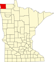 | |
| Townships | ||
| Unorganized territories | ||
| Unincorporated communities | ||
| Ghost town | ||