Teien Township, Kittson County, Minnesota

Last updated
Teien Township, Minnesota
USA Minnesota location map.svg
Red pog.svg
Teien Township
Location in Minnesota and the United States
Usa edcp location map.svg
Red pog.svg
Teien Township
Teien Township (the United States)
Coordinates: 48°34′40″N97°5′43″W / 48.57778°N 97.09528°W / 48.57778; -97.09528 Coordinates: 48°34′40″N97°5′43″W / 48.57778°N 97.09528°W / 48.57778; -97.09528
Country United States
State Minnesota
County Kittson
Area
  Total29.2 sq mi (75.7 km2)
  Land28.8 sq mi (74.5 km2)
  Water0.5 sq mi (1.3 km2)
Elevation
797 ft (243 m)
Population
 (2000)
  Total85
  Density3.0/sq mi (1.1/km2)
Time zone UTC-6 (Central (CST))
  Summer (DST) UTC-5 (CDT)
FIPS code 27-64354 [1]
GNIS feature ID0665771 [2]

Teien Township is a township in Kittson County, Minnesota, United States. The population was 85 at the 2000 census.

Contents

Minnesota State Highways 11 and 220 are two of the main routes in the township.

The unincorporated community of Robbin is located within Teien Township.

Teien Township was organized in 1882, and named for Andrew C. Teien, an early settler. [3]

Geography

According to the United States Census Bureau, the township has a total area of 29.2 square miles (75.7 km2), of which 28.8 square miles (74.5 km2) is land and 0.5 square mile (1.3 km2) (1.68%) is water.

Demographics

As of the census [1] of 2000, there were 85 people, 38 households, and 28 families residing in the township. The population density was 3.0 people per square mile (1.1/km2). There were 51 housing units at an average density of 1.8/sq mi (0.7/km2). The racial makeup of the township was 100.00% White. Hispanic or Latino of any race were 1.18% of the population.

There were 38 households, out of which 13.2% had children under the age of 18 living with them, 68.4% were married couples living together, 2.6% had a female householder with no husband present, and 23.7% were non-families. 23.7% of all households were made up of individuals, and 13.2% had someone living alone who was 65 years of age or older. The average household size was 2.24 and the average family size was 2.62.

In the township the population was spread out, with 12.9% under the age of 18, 7.1% from 18 to 24, 15.3% from 25 to 44, 30.6% from 45 to 64, and 34.1% who were 65 years of age or older. The median age was 52 years. For every 100 females, there were 107.3 males. For every 100 females age 18 and over, there were 105.6 males.

The median income for a household in the township was $36,250, and the median income for a family was $37,250. Males had a median income of $30,938 versus $21,250 for females. The per capita income for the township was $21,792. There were 5.7% of families and 4.0% of the population living below the poverty line, including no under eighteens and none of those over 64.

Related Research Articles

Skree Township is a township in Clay County, Minnesota, United States. The population was 166 at the 2000 census.

Little Pine Township is a township in Crow Wing County, Minnesota, United States. The population was 86 at the 2000 census. Little Pine Township took its name from the Little Pine River.

Spring Valley Township is a township in Fillmore County, Minnesota, United States. The population was 590 at the 2000 census.

Goodland Township is a township in Itasca County, Minnesota, United States. The population was 466 at the 2010 census.

Nore Township is a township in Itasca County, Minnesota, United States. The population was 57 at the 2010 census.

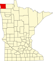
Tegner Township is a township in Kittson County, Minnesota, United States. The population was 67 at the 2000 census.

Chief Township is a township in Mahnomen County, Minnesota, United States. The population was 132 at the 2000 census.

Big Woods Township is a township in Marshall County, Minnesota, United States. The population was 79 at the 2000 census.

Cedar Township is a township in Marshall County, Minnesota, United States. The population was 94 at the 2000 census.

East Park Township is a township in Marshall County, Minnesota, United States. The population was 19 at the 2000 census.

East Valley Township is a township in Marshall County, Minnesota, United States. The population was 45 at the 2000 census.

Fork Township is a township in Marshall County, Minnesota, United States. The population was 14 at the 2000 census.

Grand Plain Township is a township in Marshall County, Minnesota, United States. The population was 55 at the 2000 census.

Moose River Township is a township in Marshall County, Minnesota, United States. The population was 28 at the 2000 census.

Nelson Park Township is a township in Marshall County, Minnesota, United States. The population was 158 at the 2000 census.

Cedar Township is a township in Martin County, Minnesota, United States. The population was 260 at the 2000 census.

Clitherall Township is a township in Otter Tail County, Minnesota, United States. The population was 549 at the 2000 census.

Effington Township is a township in Otter Tail County, Minnesota, United States. The population was 297 at the 2000 census.

Onstad Township is a township in Polk County, Minnesota, United States. It is part of the Grand Forks-ND-MN Metropolitan Statistical Area. The population was 70 at the 2000 census.

Beaver Township is a township in Roseau County, Minnesota, United States. The population was 103 at the 2000 census.

References

  1. 1 2 "U.S. Census website". United States Census Bureau . Retrieved 2008-01-31.
  2. "US Board on Geographic Names". United States Geological Survey. 2007-10-25. Retrieved 2008-01-31.
  3. Upham, Warren (1920). Minnesota Geographic Names: Their Origin and Historic Significance. Minnesota Historical Society. p.  280.