Hill Township, Kittson County, Minnesota

Last updated

Hill Township, Minnesota
USA Minnesota location map.svg
Red pog.svg
Hill Township
Location in Minnesota and the United States
Usa edcp location map.svg
Red pog.svg
Hill Township
Hill Township (the United States)
Coordinates: 48°50′25″N97°7′2″W / 48.84028°N 97.11722°W / 48.84028; -97.11722
Country United States
State Minnesota
County Kittson
Area
  Total32.3 sq mi (83.6 km2)
  Land32.0 sq mi (82.8 km2)
  Water0.3 sq mi (0.7 km2)
Elevation
797 ft (243 m)
Population
 (2000)
  Total18
  Density0.6/sq mi (0.2/km2)
Time zone UTC-6 (Central (CST))
  Summer (DST) UTC-5 (CDT)
FIPS code 27-29078 [1]
GNIS feature ID0664473 [2]

Hill Township is a township in Kittson County, Minnesota, United States. The population was 18 at the 2000 census.

Contents

Hill Township was organized in 1901, and named for James J. Hill, a railroad official. [3]

Geography

According to the United States Census Bureau, the township has a total area of 32.3 square miles (84 km2), of which 32.0 square miles (83 km2) is land and 0.3 square miles (0.78 km2) (0.90%) is water.

Demographics

As of the census [1] of 2000, there were 18 people, 7 households, and 7 families residing in the township. The population density was 0.6 people per square mile (0.2/km2). There were 10 housing units at an average density of 0.3/sq mi (0.1/km2). The racial makeup of the township was 100.00% White.

There were 7 households, out of which 28.6% had children under the age of 18 living with them, 100.0% were married couples living together, and 0.0% were non-families. No households were made up of individuals, and none had someone living alone who was 65 years of age or older. The average household size was 2.57 and the average family size was 2.57.

In the township the population was spread out, with 11.1% under the age of 18, 11.1% from 18 to 24, 44.4% from 25 to 44, 11.1% from 45 to 64, and 22.2% who were 65 years of age or older. The median age was 40 years. For every 100 females, there were 157.1 males. For every 100 females age 18 and over, there were 128.6 males.

The median income for a household in the township was $34,167, and the median income for a family was $34,167. Males had a median income of $46,250 versus $0 for females. The per capita income for the township was $9,814. About 16.7% of families and 27.3% of the population were below the poverty line, including 50.0% of those under 18 and none of those over 64.

Related Research Articles

Hill Lake Township is a township in Aitkin County, Minnesota, United States. The population was 430 as of the 2010 census.

McPherson Township is a township in Blue Earth County, Minnesota, United States. The population was 470 as of the 2000 census.

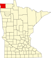
Parke Township is a township in Clay County, Minnesota, United States. The population was 450 at the 2000 census.

Daggett Brook Township is a township in Crow Wing County, Minnesota, United States. The population was 448 at the 2000 census. This township took its name from Daggett Brook.

Rabbit Lake Township is a township in Crow Wing County, Minnesota, United States. The population was 348 at the 2000 census. The township took its name from Rabbit Lake.

Solem Township is a township in Douglas County, Minnesota, United States. The population was 239 at the 2000 census.

Holt Township is a township in Fillmore County, Minnesota, United States. The population was 307 at the 2000 census.

Manchester Township is a township in Freeborn County, Minnesota, United States. The population was 469 at the 2000 census.

Alvwood Township is a township in Itasca County, Minnesota, United States. The population was 42 at the 2010 census.

Good Hope Township is a township in Itasca County, Minnesota, United States. The population was 99 at the 2010 census.

Marcell Township is a township in Itasca County, Minnesota, United States. The population was 467 at the 2010 census.

Como Township is a township in Marshall County, Minnesota, United States. The population was 52 at the 2000 census.

Dovray Township is a township in Murray County, Minnesota, United States. The population was 167 at the 2000 census. Dovray is located in Southwest Minnesota on the eastern side of Murray County. It is five minutes from Currie, fifteen minutes from Lake Shetek State Park, and twenty minutes northeast of Slayton.

Corliss Township is a township in Otter Tail County, Minnesota, United States. The population was 462 at the 2000 census.

Erhards Grove Township is a township in Otter Tail County, Minnesota, United States. The population was 467 at the 2000 census.

Deer Park Township is a township in Pennington County, Minnesota, United States. The population was 126 at the 2010 census.

Pine Lake Township is a township in Pine County, Minnesota, United States. The population was 576 at the 2000 census.

Henderson Township is a township in Sibley County, Minnesota, United States. The population was 700 at the 2000 census.

Owatonna Township is a township in Steele County, Minnesota, United States. The population was 771 at the 2000 census.

Tara Township is a township in Swift County, Minnesota, United States. The population was 121 at the 2000 census.

References

  1. 1 2 "U.S. Census website". United States Census Bureau . Retrieved January 31, 2008.
  2. "US Board on Geographic Names". United States Geological Survey. October 25, 2007. Retrieved January 31, 2008.
  3. Upham, Warren (1920). Minnesota Geographic Names: Their Origin and Historic Significance. Minnesota Historical Society. p.  278.