Robbin, Minnesota

Last updated
Robbin
USA Minnesota location map.svg
Red pog.svg
Robbin
Usa edcp location map.svg
Red pog.svg
Robbin
Coordinates: 48°34′22″N97°08′33″W / 48.57278°N 97.14250°W / 48.57278; -97.14250 Coordinates: 48°34′22″N97°08′33″W / 48.57278°N 97.14250°W / 48.57278; -97.14250
Country United States
State Minnesota
County Kittson County
Township Teien
Elevation
797 ft (243 m)
Time zone UTC-6 (Central (CST))
  Summer (DST) UTC-5 (CDT)
ZIP code
56733 and 56720
Area code(s) 218
GNIS feature ID650161 [1]

Robbin is an unincorporated community in Teien Township, Kittson County, Minnesota, United States.

Unincorporated area Region of land not governed by own local government

In law, an unincorporated area is a region of land that is not governed by a local municipal corporation; similarly an unincorporated community is a settlement that is not governed by its own local municipal corporation, but rather is administered as part of larger administrative divisions, such as a township, parish, borough, county, city, canton, state, province or country. Occasionally, municipalities dissolve or disincorporate, which may happen if they become fiscally insolvent, and services become the responsibility of a higher administration. Widespread unincorporated communities and areas are a distinguishing feature of the United States and Canada. In most other countries of the world, there are either no unincorporated areas at all, or these are very rare; typically remote, outlying, sparsely populated or uninhabited areas.

Teien Township, Kittson County, Minnesota Township in Minnesota, United States

Teien Township is a township in Kittson County, Minnesota, United States. The population was 85 at the 2000 census.

Kittson County, Minnesota County in the United States

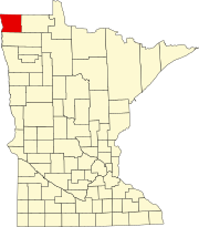
Kittson County is a county in the U.S. state of Minnesota along the Canada–US border, south of the Canadian province of Manitoba. As of the 2010 census, the population was 4,552. Its county seat is Hallock.

The community is located along the Red River, near Drayton, North Dakota. It is located along State Highway 11 (MN 11) near its junction with State Highway 220 (MN 220) and Kittson County Road 7. Nearby places also include Donaldson and Kennedy.

Red River of the North Canadian and American river

The Red River is a North American river. Originating at the confluence of the Bois de Sioux and Otter Tail rivers between the U.S. states of Minnesota and North Dakota, it flows northward through the Red River Valley, forming most of the border of Minnesota and North Dakota and continuing into Manitoba. It empties into Lake Winnipeg, whose waters join the Nelson River and ultimately flow into Hudson Bay.

Drayton, North Dakota City in North Dakota, United States

Drayton is a city in Pembina County, North Dakota, United States. The population was 824 at the 2010 census. Drayton was founded in 1878.

Minnesota State Highway 11 is a highway in northwest and north-central Minnesota, which runs from North Dakota Highway 66 at the North Dakota state line and continues east to its eastern terminus at the community of Island View at Rainy Lake, near International Falls.

Related Research Articles

Roseau County, Minnesota County in the United States

Roseau County is a county in the U.S. state of Minnesota, along the Canada–US border. As of the 2010 United States Census, the population was 15,629. Its county seat is Roseau. It is south of the border with Manitoba.

Marshall County, Minnesota County in the United States

Marshall County is a county in the U.S. state of Minnesota. As of the 2010 United States Census, the population was 9,439. Its county seat is Warren.

Minnesota State Highway 220 is a regional trunk highway in northwest Minnesota, which runs from its intersection with U.S. Highway 75 in Climax and continues north to its northern terminus at its intersection with State Highway 11 near Drayton, North Dakota. The route runs along and near the Red River.

Forbes, Minnesota Unincorporated community in Minnesota, United States

Forbes is an unincorporated community in Saint Louis County, Minnesota, United States.

Celina, Minnesota Unincorporated community in Minnesota, United States

Celina is an unincorporated community in Saint Louis County, Minnesota, United States.

Burntside, Minnesota Unincorporated community in Minnesota, United States

Burntside is an unincorporated community in Morse Township, Saint Louis County, Minnesota, United States.

Pelland, Minnesota Unincorporated community in Minnesota, United States

Pelland is an unincorporated community in Koochiching County, Minnesota, United States; located along the Rainy River.

Pontoria, Minnesota Unincorporated community in Minnesota, US

Pontoria is an unincorporated community in Ponto Lake Township, Cass County, Minnesota, United States, near Backus.

Ruskin, Minnesota Unincorporated community in Minnesota, United States

Ruskin is an unincorporated community in Rice County, Minnesota, United States.

Centerville, Winona County, Minnesota Unincorporated community in Minnesota, United States

Centerville is an unincorporated community in Wilson Township, Winona County, Minnesota, United States.

Benedict, Minnesota Unincorporated community in Minnesota, United States

Benedict is an unincorporated community in Lakeport Township, Hubbard County, Minnesota, United States.

Wildwood, Minnesota Unincorporated community in Minnesota, United States

Wildwood is an unincorporated community in Koochiching County, Minnesota, United States; located within the Pine Island State Forest.

Caribou, Minnesota Unincorporated community in Minnesota, United States

Caribou is an unincorporated community in Caribou Township, Kittson County, Minnesota, United States.

Northcote, Minnesota Unincorporated community in Minnesota, United States

Northcote is an unincorporated community in Hampden Township, Kittson County, Minnesota, United States.

Wealthwood, Minnesota Unincorporated community in Minnesota, US

Wealthwood is an unincorporated community in Wealthwood Township, Aitkin County, Minnesota, United States, along the north shore of Mille Lacs Lake. The community is located along State Highway 18 near the junction with Aitkin County Road 51, 385th Avenue. Nearby places include Garrison, Malmo, Glen, and Aitkin.

Rossburg, Minnesota Unincorporated community in Minnesota, US

Rossburg is an unincorporated community in Spencer Township, Aitkin County, Minnesota, United States. The community is located along 350th Avenue near the junction with Aitkin County Road 5, 360th Street. Nearby places include Aitkin, Glen, and Kimberly. State Highway 47 is nearby.

Kimberly, Minnesota Unincorporated community in Minnesota, US

Kimberly is an unincorporated community in Kimberly Township, Aitkin County, Minnesota, United States. The community is located along Aitkin County Road 5 near the junction with County Road 56. Nearby places include Aitkin, Rossburg, Palisade, McGregor, East Lake, and Kimberly Wildlife Management Area. The Rice River flows through the community. State Highways 47 and 210 are both nearby.

Wilkinson, Minnesota Unincorporated community in Minnesota, US

Wilkinson is an unincorporated community in Wilkinson Township, Cass County, Minnesota, United States, near Cass Lake and Walker. It is located along State Highway 371 near 122nd Street NW.

References

  1. "Robbin, Minnesota". Geographic Names Information System . United States Geological Survey.