Donaldson, Minnesota

Last updated

Donaldson
Kittson County Minnesota Incorporated and Unincorporated areas Donaldson Highlighted.svg
Location of Donaldson, Minnesota
Coordinates: 48°34′21″N96°53′44″W / 48.57250°N 96.89556°W / 48.57250; -96.89556
CountryUnited States
State Minnesota
County Kittson
Area
[1]
  Total0.23 sq mi (0.59 km2)
  Land0.23 sq mi (0.59 km2)
  Water0.00 sq mi (0.00 km2)
Elevation
[2]
830 ft (250 m)
Population
 (2020) [3]
  Total20
  Estimate 
(2021) [4]
20
  Density88.11/sq mi (33.96/km2)
Time zone UTC-6 (CST)
  Summer (DST) UTC-5 (CDT)
ZIP code
56720
Area code 218
FIPS code 27-16030
GNIS feature ID0642883 [2]

Donaldson is a city in Kittson County, Minnesota, United States. The population was 20 at the 2020 census. [3]

Contents

U.S. Route 75 and Minnesota State Highway 11 are two of the main arterial routes in the community.

History

A post office called Donaldson has been in operation since 1884. [5] The city was named for Captain W. Donaldson, a local farmer. [6]

Geography

According to the United States Census Bureau, the city has a total area of 0.83 square miles (2.15 km2), all land. [7]

Demographics

Historical population
CensusPop.Note
1910 132
1920 16726.5%
1930 133−20.4%
1940 120−9.8%
1950 1286.7%
1960 64−50.0%
1970 697.8%
1980 8421.7%
1990 57−32.1%
2000 41−28.1%
2010 422.4%
2020 20−52.4%
2021 (est.)20 [4] 0.0%
U.S. Decennial Census [8]
2020 Census [3]

2010 census

As of the census of 2010, there were 42 people, 17 households, and 12 families living in the city. The population density was 50.6 inhabitants per square mile (19.5/km2). There were 21 housing units at an average density of 25.3 per square mile (9.8/km2). The racial makeup of the city was 100.0% White.

There were 17 households, of which 29.4% had children under the age of 18 living with them, 52.9% were married couples living together, 11.8% had a female householder with no husband present, 5.9% had a male householder with no wife present, and 29.4% were non-families. 29.4% of all households were made up of individuals. The average household size was 2.47 and the average family size was 3.08.

The median age in the city was 39 years. 28.6% of residents were under the age of 18; 2.3% were between the ages of 18 and 24; 26.2% were from 25 to 44; 21.5% were from 45 to 64; and 21.4% were 65 years of age or older. The gender makeup of the city was 54.8% male and 45.2% female.

2000 census

As of the census of 2000, there were 41 people, 18 households, and 10 families living in the city. The population density was 49.6 inhabitants per square mile (19.2/km2). There were 22 housing units at an average density of 26.6 per square mile (10.3/km2). The racial makeup of the city was 97.56% White, and 2.44% from two or more races. Hispanic or Latino of any race were 2.44% of the population.

There were 18 households, out of which 27.8% had children under the age of 18 living with them, 38.9% were married couples living together, 11.1% had a female householder with no husband present, and 38.9% were non-families. 38.9% of all households were made up of individuals, and 11.1% had someone living alone who was 65 years of age or older. The average household size was 2.28 and the average family size was 3.00.

In the city, the population was spread out, with 26.8% under the age of 18, 4.9% from 18 to 24, 34.1% from 25 to 44, 29.3% from 45 to 64, and 4.9% who were 65 years of age or older. The median age was 39 years. For every 100 females, there were 141.2 males. For every 100 females age 18 and over, there were 172.7 males.

The median income for a household in the city was $26,875, and the median income for a family was $34,375. Males had a median income of $31,250 versus $16,250 for females. The per capita income for the city was $11,637. There are 18.2% of families living below the poverty line and 7.7% of the population, including no under eighteens and none of those over 64.

Related Research Articles

<span class="mw-page-title-main">Craig, Iowa</span> City in Iowa, United States

Craig is a city in Plymouth County, Iowa, United States. The population was 79 at the 2020 census.

Arveson Township is a township in Kittson County, Minnesota, United States. The population was 100 at the 2000 census.

Caribou Township is a township in Kittson County, Minnesota, United States.

Clow Township is a township in Kittson County, Minnesota, United States. The population was 37 at the 2000 census.

Davis Township is a township in Kittson County, Minnesota, United States. The population was 48 at the 2000 census.

Granville Township is a township in Kittson County, Minnesota, United States. The population was 104 at the 2000 census.

<span class="mw-page-title-main">Hallock, Minnesota</span> City in Minnesota, United States

Hallock is a city in and the county seat of Kittson County, Minnesota, United States. The population was 906 at the 2020 census.

<span class="mw-page-title-main">Halma, Minnesota</span> City in Minnesota, United States

Halma is a city in Kittson County, Minnesota, United States. The population was 58 at the 2020 census.

<span class="mw-page-title-main">Humboldt, Minnesota</span> City in Minnesota, United States

Humboldt is a city in Kittson County, Minnesota, United States. The population was 41 at the 2020 census.

<span class="mw-page-title-main">Kennedy, Minnesota</span> City in Minnesota, United States

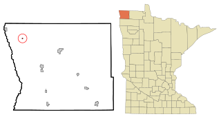
Kennedy is a city in Kittson County, Minnesota, United States. The population was 176 at the 2020 census.

<span class="mw-page-title-main">Lake Bronson, Minnesota</span> City in Minnesota, United States

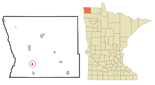
Lake Bronson is a city in Kittson County, Minnesota, United States. The population was 178 at the 2020 census. Lake Bronson State Park is nearby.

<span class="mw-page-title-main">Lancaster, Minnesota</span> City in Minnesota, United States

Lancaster is a city in Kittson County, Minnesota, United States. As of the 2020 census, the city population was 364.

North Red River is an unorganized territory located in Kittson County, Minnesota, United States. The area was organized as a civil township, North Red River Township, until Kittson County dissolved the township in 2000 following a vote in the Minnesota legislature that allowed the county to do so without an election. In 2000, the township had a population of three, and as of the 2010 census, the territory had a total population of zero.

Percy Township is a township in Kittson County, Minnesota, United States. The population was 48 at the 2000 census.

Richardville Township is a township in Kittson County, Minnesota, United States. The population was 110 at the 2000 census.

<span class="mw-page-title-main">St. Vincent, Minnesota</span> City in Minnesota, United States

St. Vincent is a hamlet in Kittson County, Minnesota, United States. The population was 57 at the 2020 census.

St. Vincent Township is a township in Kittson County, Minnesota, United States. The population was 74 at the 2000 census.

<span class="mw-page-title-main">Grand Meadow, Minnesota</span> City in Minnesota, United States

Grand Meadow is a city in Mower County, Minnesota, United States. The city is on the boundary between Grand Meadow Township and Frankford Township, and it is politically independent of both townships. The population was 1,139 at the 2010 census.

<span class="mw-page-title-main">Bertha, Minnesota</span> City in Minnesota, United States

Bertha is a city in Todd County, Minnesota, United States. The population was 497 at the 2010 census.

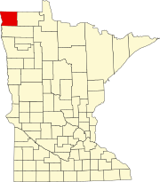
East Kittson is an unorganized territory in Kittson County, Minnesota, United States, named after fur trader and railroad entrepreneur Norman Kittson. The population was 13 at the 2000 census.

References

  1. "2020 U.S. Gazetteer Files". United States Census Bureau. Retrieved July 24, 2022.
  2. 1 2 U.S. Geological Survey Geographic Names Information System: Donaldson, Minnesota
  3. 1 2 3 "Explore Census Data". United States Census Bureau . Retrieved May 2, 2022.
  4. 1 2 "City and Town Population Totals: 2020-2021". United States Census Bureau. June 25, 2022. Retrieved June 25, 2022.
  5. "Kittson County". Jim Forte Postal History. Retrieved July 17, 2015.
  6. Upham, Warren (1920). Minnesota Geographic Names: Their Origin and Historic Significance. Minnesota Historical Society. p.  277.
  7. "US Gazetteer files 2010". United States Census Bureau. Archived from the original on July 2, 2012. Retrieved November 13, 2012.
  8. United States Census Bureau. "Census of Population and Housing" . Retrieved September 11, 2013.

48°34′20″N96°53′47″W / 48.57222°N 96.89639°W / 48.57222; -96.89639