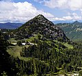
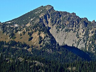
Pinnacle Peak is a 6,562 ft peak located in Mount Rainier National Park in Lewis County, Washington. It is the second highest peak in the Tatoosh Range. There are two other Washington summits with the same name: Pinnacle Peak near Enumclaw, Washington, roughly 30 miles (50 km) to the northwest, and Pinnacle Peak in North Cascades State Park.
Dege Peak is a 7,006-foot summit located in Pierce County of Washington state. It is part of the Sourdough Mountains in Mount Rainier National Park. It was named in 1932 for James Henry Dege, a prominent Tacoma businessman and Captain of the First Regiment National Guard of Washington. His mother was a descendant of President Zachary Taylor.

Antler Peak is a 7,017-foot (2,139-metre) summit located in Mount Rainier National Park in Pierce County of Washington state. It is part of the Sourdough Mountains, a subset of the Cascade Range. Antler Peak is situated west of Dege Peak and northeast of Sunrise Historic District, with the Sourdough Ridge Trail traversing the south slope of Antler between the two. Mount Fremont is the nearest higher peak, 1.55 mi (2.49 km) to the west. Precipitation runoff from Antler Peak drains into the White River.

Mount Fremont is a 7,214-foot-elevation mountain summit located in Mount Rainier National Park in Pierce County of Washington state. Mount Fremont is a minor peak at the southwest corner of the Sourdough Mountains which are a subset of the Cascade Range. It also the juncture for a small ridge of peaks of similar size running to the northeast. Mount Fremont is situated northwest of the Sunrise Historic District, with a popular trail leading to the Mount Fremont Fire Lookout. However, this trail does not reach the true summit which is 0.25 mi (0.40 km) north of Frozen Lake. Peak 7317, also known as Mount Fremont North, located 0.31 mi (0.50 km) west-northwest along the ridge is its nearest higher neighbor. Access is limited by snowpack closing the Sunrise Road much of the year. July, August, and September are typically the months when the Sunrise Road is seasonally open for vehicle traffic. Precipitation runoff from Mount Fremont drains into the White River.

Marcus Peak is a 6,962-foot (2,122 m) summit located in Mount Rainier National Park in Pierce County of Washington state. It is part of the Sourdough Mountains which are a small subset of the Cascade Range, and it is situated north of Dege Peak. The peak was named in 1932 for Marcus Whitman (1802–1847), an early pioneer and physician. The Whitman Glacier on Little Tahoma also honors him. Access to Marcus Peak is limited due to snow closing the Sunrise Road much of the year. July, August, and September are typically the months when the Sunrise Road is seasonally open for vehicle traffic. The nearest higher peak is Palisades Peak, 0.64 miles (1.03 km) to the north-northeast. Precipitation runoff from Marcus Peak drains into the White River.

Yakima Peak is a 6,226-ft summit located on the eastern border of Mount Rainier National Park. It is also on the shared border of Pierce County and Yakima County in Washington state. Yakima Peak is situated northwest of Tipsoo Lake and west of Chinook Pass on the crest of the Cascade Range. Yakima Peak is a major triple divide point with precipitation runoff draining into tributaries of the White River, Cowlitz River, and Yakima River. Its nearest higher neighbor is Deadwood Peak, 0.59 mi (0.95 km) to the north. The name Yakima Peak honors the Yakima Tribe of eastern Washington state. From Chinook Pass, a short scramble up a gully on the north side leads to a flat summit with unobstructed views of Mount Rainier and Naches Peak.

Deadwood Peak is a 6,280-foot-elevation mountain summit located on the eastern border of Mount Rainier National Park. It is also situated on the shared border of Pierce County and Yakima County in Washington state. Deadwood Peak is set on the crest of the Cascade Range, immediately north of Yakima Peak and Chinook Pass, with the Pacific Crest Trail traversing its east slope. Its nearest higher peak is Naches Peak, 0.59 mi (0.95 km) to the southeast. Deadwood Peak takes its name from Deadwood Lakes and Deadwood Creek to its northwest, and their names came from the large number of downed trees in the area. From Chinook Pass, a short scramble up the south side leads to the summit with unobstructed views of Mount Rainier.

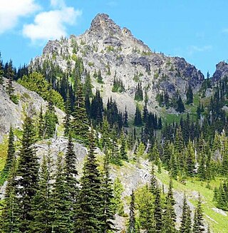
Tamanos Mountain is a 6,790-foot (2,070 m) summit located in Mount Rainier National Park in Pierce County of Washington state. It is part of the Cascade Range. Tamanos Mountain is situated west of Governors Ridge and northeast of the Cowlitz Chimneys, all of which can be seen from the Sunrise Historic District. The name tamanos derives from Chinook Jargon and has the meaning of guardian spirit. This landform's toponym was officially adopted by the U.S. Board on Geographic Names in 1932. Topographic relief is significant as the summit rises 3,100 feet above the White River in approximately 1.5 mile. The normal climbing access is from the Owyhigh Lakes Trail, and from the lakes scrambling up the south slope to the summit.
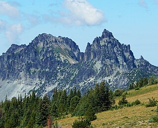
Sluiskin Mountain is a prominent pair of summits located in Mount Rainier National Park in Pierce County of Washington state. It is situated northwest of Burroughs Mountain and is part of the Cascade Range. The higher rocky peak is known as The Chief (7026 ft), and the second peak to the west is known as The Squaw. West of The Squaw are pinnacles called The Papooses. Sluiskin was the native American guide who assisted with the first successful ascent of Mount Rainier by Hazard Stevens and P. B. Van Trump in 1870. Sluiskin Falls within the park also honors him.

Banshee Peak is a 7,420-foot (2,262-metre) mountain summit located in Mount Rainier National Park in Pierce County of Washington state, US. As part of the Cascade Range, Banshee Peak is situated west of the Cowlitz Chimneys and east of Panhandle Gap, with the Sarvant Glacier set below its north cliff. Precipitation runoff from Banshee Peak drains into tributaries of the White River and the Cowlitz River. Banshee Peak is a high remnant of bedded Ohanapecosh Formation lava flows. Access is from Panhandle Gap via the Wonderland Trail. The broad summit has alpine tundra similar to that found on Burroughs Mountain. The Sunrise Historic District provides a viewpoint from which to see Banshee Peak when weather permits. The road to Sunrise is only open seasonally in the summer due to closure from winter snowpack.

Barrier Peak is a small 6,521-foot (1,988-metre) summit located in Mount Rainier National Park in Pierce County of Washington state. It is part of the Cascade Range and is situated west of Cayuse Pass, 0.53 mile west-northwest of Buell Peak, and 0.4 mile south-southwest of Governors Ridge, which is its nearest higher peak. Precipitation runoff from Barrier Peak drains into tributaries of the White River and Cowlitz River. The normal climbing access is from the Owyhigh Lakes Trail. The peak was so named because it served as a barrier between the Cayuse Pass region and the rest of Mount Rainier National Park.
Three Way Peak is a 6,796 feet (2,071 m) summit located on the eastern border of Mount Rainier National Park. It is also on the shared border of Pierce County and Yakima County in Washington state. Three Way Peak is situated 0.42 mi (0.68 km) north of Cupalo Rock on the crest of the Cascade Range. Its nearest higher peak is Crystal Mountain, 0.56 mi (0.90 km) to the northwest. Chinook Peak is 0.8 mile to the southwest. Precipitation runoff from Three Way Peak drains into tributaries of the White River and Naches River.
Palisades Peak is a 7,040-foot (2,146 m) summit located in Mount Rainier National Park in Pierce County of Washington state. It is part of the Sourdough Mountains, a subset of the Cascade Range, and is situated 0.6 mile north of Marcus Peak. The peak's descriptive name stems from the resemblance of its columnar basalt cliffs to a palisade. Access is via Palisades Lakes Trail which starts at Sunrise Point. Access to Sunrise Point is limited due to snowpack closing the Sunrise Road much of the year. July, August, and September are typically the months when the Sunrise Road is seasonally open for vehicle traffic. Precipitation runoff from Palisades Peak drains into the White River.

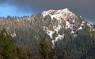
Skyscraper Mountain is a 7,078-foot-elevation (2,157-meter) summit in Pierce County of Washington state.

Crystal Peak is a 6,595-foot summit located in eastern Mount Rainier National Park, in Pierce County of Washington state. Crystal Peak is situated 0.75 mi (1.21 km) northwest of Chinook Peak, and nearly on the crest of the Cascade Range. Crystal Mountain and Crystal Lakes lie immediately to the northeast, and Three Way Peak is 1.09 mi (1.75 km) to the east. Access to the summit is via a hiking trail which branches off from the Crystal Lakes Trail. That trailhead starts along Highway 410, which traverses the western base of the mountain. Precipitation runoff from Crystal Peak drains into tributaries of the White River.

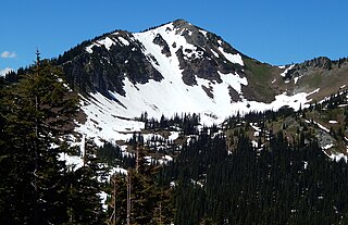
Old Desolate is a 7,137-foot (2,175 m) multi-summit, ridge-like mountain located in Mount Rainier National Park, in Pierce County of Washington state. It is part of the Cascade Range, and lies five miles (8.0 km) due north of the summit of Mount Rainier. The Wonderland Trail provides an approach to this mountain, and the summit offers views of Sluiskin Mountain and Mount Rainier. Burroughs Mountain is the nearest higher neighbor, 2.37 mi (3.81 km) to the southeast. Precipitation runoff from Old Desolate drains east into the West Fork White River, or west into the Carbon River.

Goat Island Mountain is a 7,288-foot (2,221 m) ridge-like mountain located in Mount Rainier National Park, in Pierce County of Washington state. It is part of the Cascade Range, and lies 5.76 mi (9.27 km) east-northeast of the summit of Mount Rainier. This mountain is quite visible from the Sunrise Historic District and the many trails surrounding the Sunrise area. The Wonderland Trail provides an approach to this mountain, and the summit offers views of Cowlitz Chimneys, Fryingpan Glacier, and Mount Rainier. Burroughs Mountain is its nearest higher neighbor, 2.51 mi (4.04 km) to the northwest. Precipitation runoff from Goat Island Mountain drains into the White River. The mountain's descriptive name derives from mountain goats that were often seen on the peak. The toponym was officially adopted in 1932 by the United States Board on Geographic Names.
Mother Mountain is a 6,480+ ft multi-summit, 3-mile long ridge-like mountain located in Mount Rainier National Park, in Pierce County of Washington state. It is part of the Cascade Range, and lies 7 mi (11 km) northwest of the summit of Mount Rainier. The Wonderland Trail provides one approach option to this mountain, and the summit offers views of Mount Rainier. East Fay Peak is its nearest higher neighbor, 0.42 mi (0.68 km) to the south. Precipitation runoff from Mother Mountain is drained by Cataract Creek on the south side of the mountain, and Ipsut Creek drains the north side of it, and both are tributaries of the Carbon River. The west side drains into Mowich Lake, and thence Mowich River.

Fay Peak is a double-summit mountain located in Mount Rainier National Park, in Pierce County of Washington state. It is part of the Cascade Range, and lies seven miles (11 km) northwest of the summit of Mount Rainier. The 6,492-foot elevation summit of Fay Peak lies a quarter-mile west of the highest point, East Fay Peak, 6,520+ ft. Echo Rock is its nearest higher neighbor, 2.7 mi (4.3 km) to the southeast. Precipitation runoff from Fay Peak is drained by Cataract Creek on the east side of the mountain, and the west side drains into Mowich Lake and Mowich River.
Mount Wow is a prominent 6,040+ ft mountain summit located in the southwest corner of Mount Rainier National Park, in Pierce County of Washington state. It is part of the Cascade Range, and lies 8.6 mi (13.8 km) southwest of the summit of Mount Rainier. Its nearest higher neighbor is Iron Mountain, 3.6 mi (5.8 km) to the east-northeast. Precipitation runoff from Mount Wow is drained by Tahoma Creek on the east side of the mountain, whereas Goat Creek drains the west side of it, and both are tributaries of the Nisqually River.