Meadow Heights Melbourne, Victoria | |||||||||||||||
---|---|---|---|---|---|---|---|---|---|---|---|---|---|---|---|
![]() Paringa Boulevard, Meadow Heights | |||||||||||||||
![]() | |||||||||||||||
Coordinates | 37°39′00″S144°55′19″E / 37.650°S 144.922°E | ||||||||||||||
Population | 14,890 (2021 census) [1] | ||||||||||||||
• Density | |||||||||||||||
Established | 1980s | ||||||||||||||
Postcode(s) | 3048 | ||||||||||||||
Area | 4.6 km2 (1.8 sq mi) | ||||||||||||||
Location | 18 km (11 mi) N of Melbourne | ||||||||||||||
LGA(s) | City of Hume | ||||||||||||||
State electorate(s) | Greenvale | ||||||||||||||
Federal division(s) | Calwell | ||||||||||||||
|
Meadow Heights is a suburb in Melbourne, Victoria, Australia, 18 km (11 mi) north of Melbourne's Central Business District, located within the City of Hume local government area. Meadow Heights recorded a population of 14,890 at the 2021 census. [1]
Meadow Heights is bounded by Somerton Road in the north, Pascoe Vale Road in the east, Barry Road in the south and the Broadmeadows Valley Park in the west. [2]
Until gazetted as a suburb in the late 1990s, Meadow Heights was a housing estate planned within Coolaroo. [3] [4]
When still open country, Meadow Heights was known as Broadmeadows North. The land was acquired by the Housing Commission for one of its several estates in the Broadmeadows region. Coolaroo, immediately east of Meadow Heights was built by the Commission during 1966-72. In 1975 the Commission started building at Meadow Heights, although at that time the new estate was named Westmeadows Heights. (See separate entry on Westmeadows for an explanation of the name.) In 1982 the new estate was also considered to be part of Coolaroo. [3] [4]
Westmeadows Heights primary school opened in 1977, and Bethal primary school opened two years later. Both came commendably early in the growth of new public housing estates. After 1981 the Commission withdrew from house construction and left it to the private sector to complete the estate. Completion of the suburb took until the 1990s, with a post office not opening until 1995. [3] [4]
There is a shopping centre in the middle of Meadow Heights, (1994) with an Islamic mosque and cultural centre,(2007) a Catholic church and learning centre, and a community centre to the south. The Coolaroo railway station (2010) is immediately south-east of Meadow Heights. [3] [4]
Meadow Heights Post Office opened on 6 March 1995. [5] [3] [4]
In recent years, developers have focused their efforts on suburbs to the north, with very few new housing projects being completed since 2000. [3] [4]
The most common ancestries in Meadow Heights were 21.8% Turkish, 12.2% Australian, 9.4% English, 9.0% Lebanese and 4.4% Iraqi. 46.3% of people were born in Australia. The most common countries of birth were 11.1% Turkey, 7.1% Iraq, 4.3% Lebanon, 3.0% Syria and 2.5% Vietnam.
23.5% of people only spoke English at home. Other languages spoken at home included 20.8% Turkish, 17.9% Arabic, 4.8% Assyrian Neo-Aramaic, 3.9% Vietnamese, and 3.2% Urdu.
The most common responses for religion in Meadow Heights were 48.1% Islam, 18.1% Catholic, 9.7% No Religion and 2.4% Assyrian Apostolic. [6]
Meadow Heights has two primary schools (Meadow Heights Primary School and Bethal Primary School) and several childcare centres.
Meadow Heights offers several places of interest, with the nearest cinema complex located to the south, in Broadmeadows. There are several youth centres for social activities and there is a soccer team in the area.
There are around four milk bars; on Bicentennial Crescent and Magnolia Boulevard in the north, Taggerty Crescent in the centre, and one on Eldorado Crescent to the south.
The main shopping centre is the Meadow Heights Shopping Centre, which is located on Paringa Boulevard. It features a SUPA IGA Supermarket and over 25 specialty shops.
There is also a mosque in Meadow Heights, near the shopping centre.
A community centre and a skate bowl are located in the Buchan Street Reserve.
Meadow Heights has parks all throughout the suburb, the largest of which is the Broadmeadows Valley Park, which starts from Meadow Heights right down to Jacana, with a bike trail alongside. The park has soccer fields and playgrounds near Barry Road and Magnolia Boulevard, providing barbecue and picnic areas for residents. Shankland Wetlands has a variety of introduced and native birds. The wetlands is located south of Meadow Heights, at the end of Barry Road.
Six bus routes service Meadow Heights.
The following bus routes run through Meadow Heights:
The following bus routes travel along the boundaries of Meadow Heights:
Meadow Heights is bordered by Pascoe Vale Road on the east, parkland on the west, Barry Road on the south and Somerton Road to the north.
The area is also served extensively by local taxi companies.
Coolaroo and Roxburgh Park are the nearest railway stations to Meadow Heights. Both are located on the Craigieburn line.
Broadmeadows is a suburb in Melbourne, Victoria, Australia, 15 km (9.3 mi) north of Melbourne's Central Business District and the council seat of the City of Hume local government area. Broadmeadows recorded a population of 12,524 at the 2021 census.
Campbellfield is a suburb in Melbourne, Victoria, Australia, 13 km (8.1 mi) north of Melbourne's Central Business District, located within the City of Hume local government area. Campbellfield recorded a population of 4,977 at the 2021 census.
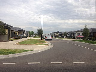
Craigieburn is a suburb in Melbourne, Victoria, Australia, 25 km (16 mi) north of Melbourne's Central Business District, located within the City of Hume local government area. Craigieburn recorded a population of 66,146 at the 2021 census.
Coolaroo is a suburb in Melbourne, Victoria, Australia, 18 km (11 mi) north of Melbourne's Central Business District, located within the City of Hume local government area. Coolaroo recorded a population of 3,193 at the 2021 census.
Greenvale is a suburb in Melbourne, Victoria, Australia, 20 km (12 mi) north of Melbourne's Central Business District, located within the City of Hume local government area. Greenvale recorded a population of 21,274 at the 2021 census.
Roxburgh Park is a suburb in Melbourne, Victoria, Australia, 21 km (13 mi) north of Melbourne's Central Business District, located within the City of Hume local government area. Roxburgh Park recorded a population of 24,129 at the 2021 census.
Westmeadows is a suburb in Melbourne, Victoria, Australia, 16 km (9.9 mi) north-west of Melbourne's Central Business District, located within the City of Hume local government area. Westmeadows recorded a population of 6,502 at the 2021 census.
Glenroy is a suburb in Melbourne, Victoria, Australia, 12 km (7.5 mi) north of Melbourne's Central Business District, located within the City of Merri-bek local government area. Glenroy recorded a population of 23,792 at the 2021 census.
Pascoe Vale is a suburb in Melbourne, Victoria, Australia, 9 km (5.6 mi) north of Melbourne's Central Business District, located within the City of Merri-bek local government area. Pascoe Vale recorded a population of 18,171 at the 2021 census.
Pascoe Vale railway station is located on the Craigieburn line in Victoria, Australia. It serves the northern Melbourne suburb of Pascoe Vale, and opened on 10 November 1885.
Glenroy railway station is located on the Craigieburn line in Victoria, Australia. It serves the northern Melbourne suburb of Glenroy, and opened on 24 January 1887.
Broadmeadows railway station is located on the Craigieburn line in Victoria, Australia. It serves the northern Melbourne suburb of Broadmeadows, and opened on 1 February 1873.
The Division of Calwell is an Australian Electoral Division in the state of Victoria.
Oak Park is a suburb in Melbourne, Victoria, Australia, 11 km (6.8 mi) north of Melbourne's Central Business District, located within the City of Merri-bek local government area. Oak Park recorded a population of 6,714 at the 2021 census.
Hadfield is a suburb in Melbourne, Victoria, Australia, 12 km (7.5 mi) north of Melbourne's Central Business District, located within the City of Merri-bek local government area. Hadfield recorded a population of 6,269 at the 2021 census.
Upfield is a small residential and industrial locality 17 km away from the central business district in the northern suburbs of Melbourne, Victoria, Australia situated in the suburb of Campbellfield. It is in the local government area of the City of Hume. The name is descriptive of the area's open country.
Jacana is a suburb in Melbourne, Victoria, Australia, 14 km (8.7 mi) north of Melbourne's Central Business District, located within the City of Hume local government area. Jacana recorded a population of 2,187 at the 2021 census.
Gladstone Park is a suburb in Melbourne, Victoria, Australia, 15 km (9.3 mi) north-west of Melbourne's Central Business District, located within the City of Hume local government area. Gladstone Park recorded a population of 8,213 at the 2021 census.
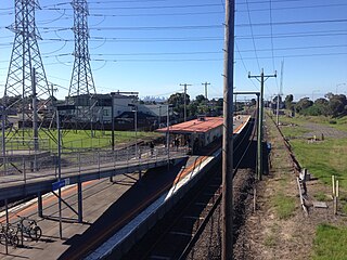
Coolaroo railway station is located on the Craigieburn line in Victoria, Australia. It serves the northern Melbourne suburb of Coolaroo, and it opened on 6 June 2010.
Roxburgh Park railway station is located on the Craigieburn line in Victoria, Australia. It serves the northern Melbourne suburb of Roxburgh Park, and opened on 21 September 2007.