Almaden Valley, or simply Almaden is a valley and primarily upper middle class residential neighborhood of San Jose, California, in South San Jose.

Naglee Park is a historic residential neighborhood in San Jose California, to the east of Downtown San Jose and San Jose State University.

The Japanese Friendship Garden is a walled section of Kelley Park in San Jose, California, United States. Dedicated in October 1965, it is patterned after Japan's famous Korakuen Garden in Okayama and spans six acres. Its three main ponds were stocked with koi sent from Okayama in 1966. The ponds are at different elevations in the park, and are inter-connected by streams.

Almaden Quicksilver County Park is a 4,163 acres (17 km²) park that includes the grounds of former mercury ("quicksilver") mines adjacent to south San Jose, California, USA. The park's elevation varies greatly: the most used entrances are less than 600 feet above sea level, while the highest point in the park is over 1,700 feet above sea level.
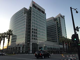
Downtown San Jose is the central business district of San Jose, California, in Silicon Valley. It is the largest urban center of Silicon Valley. Downtown is one of the largest tech clusters in Silicon Valley, as well as the cultural and political center of San Jose.
Blossom Valley is a neighborhood in the southern region of San Jose, California, northeast of the Los Capitancillos Ridge that separates it from Almaden Valley. It is located east of Cambrian and northeast of Almaden neighborhoods. It is just northeast of the Santa Teresa Hills and the Almaden Valley. Neighborhoods within Blossom Valley include Erikson, Thousand Oaks, and Pinehurst at, respectively, the southwest, northwest, and northeast quadrants of Pearl Avenue and Branham Lane.

South San Jose is the southern region of San Jose, California in Silicon Valley. The name "South Side" refers to an area bounded roughly by Hillsdale Avenue and Capitol Expressway to the North, Camden Avenue to the West, Highway 101 and Hellyer Avenue on the east, the border with the city of Morgan Hill towards the south, and to the west.

The Berryessa District or North Valley in the North San Jose region of San Jose, California is located in the northeast portion of the city, between Coyote Creek and the Diablo Range foothills. The name comes from a member of the prominent Basque–Spanish Berreyesa family: Nicolas Berreyesa, a Californio settler who was granted Rancho Milpitas in 1834.

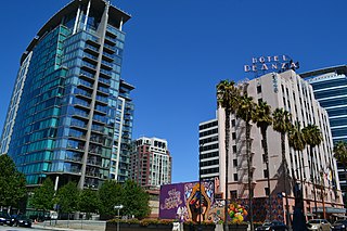
The Alameda is an alameda and historic district in San Jose, California, west of Downtown San Jose.

The Coast Line is a railroad line between Burbank, California and the San Francisco Bay Area, roughly along the Pacific Coast. It is the shortest rail route from Los Angeles to the Bay Area.

Frontier Village was a 39-acre (16 ha) amusement park in San Jose, California, that operated from 1961 to September 1980. It was located at 4885 Monterey Road and Branham Lane. The park was located on what is now Edenvale Garden Park, next to the Hayes Mansion, and was once part of the sprawling Hayes Family Estate. The park was built by Joseph Zukin, Jr. of Palo Alto, CA and largely designed by movie set designer Laurence Hollings

Mabury is an area in San Jose, California belonging to the zip code of 95133. There are two parks belonging to the area of Mabury. One, Overfelt Gardens, located at McKee Road and Educational Park Drive between East San Jose and the North Valley, pays tributes to Asian culture that thrives in and around its parts. The other is the Penitencia Creek County Park, located at Mabury Road and North Jackson Avenue, is a 78 acres linear park and regional trail.

Agnews Developmental Center was a psychiatric and medical care facility, located in Santa Clara, California.
Stoneridge Shopping Center is an upscale major shopping mall in Pleasanton, California. The mall is managed and co-owned by Simon Property Group, and is adjacent to Interstate 680.
Evergreen is a neighborhood and district of San Jose, California. Evergreen is bounded by Tully Road to the north, Capitol Expressway to the west, San Felipe Road to the south and the East Foothills neighborhood on the eastern edge.

Emma Prusch Farm Park is a 43.5 acre park in East San Jose, California. Donated by Emma Prusch to the City of San Jose in 1962 to use to demonstrate the valley's agricultural past, it includes a 4-H barn, community gardens, a rare-fruit orchard, demonstration gardens, picnic areas, and expanses of lawn. The park is host to an annual Harvest Festival and is operated cooperatively by the San Jose Parks and Recreation Department and the non-profit Emma Prusch Farm Park Foundation.

The Japanese American Museum of San Jose (JAMsj) is located at 535 N. Fifth Street in San Jose, in the heart of Japantown. The museum's mission is to collect, preserve, and share Japanese American art, history, and culture with an emphasis on the Greater San Francisco Bay Area.
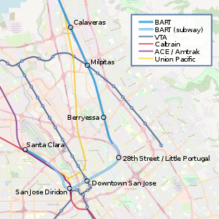
Alum Rock/28th Street station is a proposed underground Bay Area Rapid Transit station in the Little Portugal neighborhood of San Jose, California. It would be located north of East Santa Clara Street between North 28th Street and U.S. Route 101, behind Five Wounds Portuguese National Church. Preceded by the Berryessa/North San Jose BART station, it would be the first station of the Phase II portion of the Silicon Valley BART extension. The station would have direct service to Santa Clara, Richmond, and San Francisco/Daly City. The proposed station is named after Alum Rock, a neighborhood to the northeast.