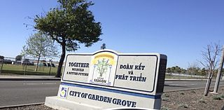
Little Saigon is a name given to ethnic enclaves of expatriate Vietnamese mainly in English-speaking countries. Alternate names include Little Vietnam and Little Hanoi, depending on the enclave's political history. Saigon is the former name of the capital of the former South Vietnam, where a large number of first-generation Vietnamese immigrants arriving to the United States originate, whereas Hanoi is the current capital of Vietnam.
East San Jose is the eastern region of San Jose, California in Silicon Valley, comprising several neighborhoods and including a former city of that name. The area is bounded roughly by Berryessa Rd to the north, the Diablo Range toward the east, Highway 101 and portions of Yerba Buena Rd and Silver Creek Valley Rd towards the south, and Highway 101 to the west.
Downtown San Jose is the central business district of San Jose, California, in Silicon Valley. It is the largest urban center of Silicon Valley. Downtown is one of the largest tech clusters in Silicon Valley, as well as the cultural and political center of San Jose.
The Berryessa District or North Valley in the North San Jose region of San Jose, California is located in the northeast portion of the city, between Coyote Creek and the Diablo Range foothills. The name comes from a member of the prominent Basque–Spanish Berreyesa family: Nicolas Berreyesa, a Californio settler who was granted Rancho Milpitas in 1834.
Westgate Center is a 640,000 sq ft (59,000 m2) regional shopping center located in the West San Jose neighborhood of San Jose, California. The mall is located at the intersection of Saratoga Avenue and Campbell Avenue. Current major anchor tenants include Burlington Coat Factory, Nordstrom Rack, Ross Dress for Less, T.J. Maxx, and Target, along with Michael's, Old Navy, Gap Factory Store, and Nike Factory Store.
The city of San Antonio in the U.S. state of Texas is composed of a number of neighborhoods and districts, spreading out surrounding the central Downtown Area.

VTA Light Rail is a light rail system serving San Jose, California, and its suburbs in Silicon Valley. It is operated by the Santa Clara Valley Transportation Authority, or VTA, and consists of 42.2 miles (67.9 km) of network comprising two main lines and a spur line on standard gauge tracks. Originally opened on December 11, 1987, the light rail system has gradually expanded since then, and currently has 60 light rail stations in operation on the three lines. VTA operates a fleet of Kinki Sharyo Low Floor Light Rail Vehicles (LFLRV) to service its passengers. The system's average weekday daily ridership as of Q3 2018 is 28,800 passengers; the greatest daily average recorded over a month was 37,536 in June 2008.

Uptown Oakland or The Uptown is a neighborhood in Downtown Oakland, California. Its boundaries are ill-defined, but most definitions include the area between 27th Street to the north, San Pablo Avenue to the west, City Center to the south, and Harrison St to the east. The neighborhood has become an important entertainment district in recent years.

The San Jose McEnery Convention Center is a convention center in San Jose, California, United States. The 550,000-square-foot (51,000 m2) facility is the largest convention center in Silicon Valley. It is named after Tom McEnery, a former Mayor of San Jose.
Van Nuys Boulevard is a major north-south arterial road that runs through the central San Fernando Valley of Los Angeles County, California. The boulevard was notable for its cruising lifestyle that was prevalent in the 1960s and 1970s, which was depicted in the 1979 film Van Nuys Blvd.
Soto Street is a major north-south thoroughfare in Los Angeles, California, connecting the southernmost neighborhoods of the Eastside, as well as the southeastern suburbs of Vernon and Huntington Park.
Alum Rock Airport was an early airport in the former town of Alum Rock, now within the city limits of San Jose, California, near the intersection of Alum Rock Avenue and Capitol Avenue. The airport was established in 1919 by Reserve Lieutenant Johnny Johnston after returning from World War I. Much of the early aerial photography of the then-rural Santa Clara Valley was taken on flights from the Alum Rock Airport.
There are 21 routes assigned to the "G" zone of the California Route Marker Program, which designates county routes in California. The "G" zone includes county highways in Monterey, San Benito, San Luis Obispo, Santa Clara, and Santa Cruz counties.
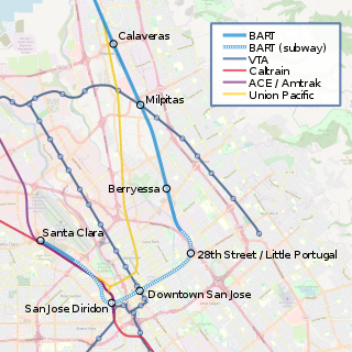
Alum Rock/28th Street station is a proposed underground Bay Area Rapid Transit station in the Little Portugal neighborhood of San Jose, California. It would be located north of East Santa Clara Street between North 28th Street and U.S. Route 101, behind Five Wounds Portuguese National Church. Preceded by the Berryessa/North San Jose BART station, it would be the first station of the Phase II portion of the Silicon Valley BART extension. The station would have direct service to Santa Clara, Richmond, and San Francisco/Daly City. The proposed station is named after Alum Rock, a neighborhood to the northeast.

The Chicano Art Movement represents attempts by Mexican-American artists to establish a unique artistic identity in the United States. Much of the art and the artists creating Chicano Art were heavily influenced by Chicano Movement which began in the 1960s. Chicano art was influenced by post-Mexican Revolution ideologies, pre-Columbian art, European painting techniques and Mexican-American social, political and cultural issues. The movement worked to resist and challenge dominant social norms and stereotypes for cultural autonomy and self-determination. Some issues the movement focused on were awareness of collective history and culture, restoration of land grants, and equal opportunity for social mobility. Throughout the movement and beyond, Chicanos have used art to express their cultural values, as protest or for aesthetic value. The art has evolved over time to not only illustrate current struggles and social issues, but also to continue to inform Chicano youth and unify around their culture and histories. Chicano art is not just Mexican-American artwork: it is a public forum that emphasizes otherwise "invisible" histories and people in a unique form of American art.

Christmas in the Park is a Winter event that takes place each year in downtown San Jose, California, roughly from the last week of November to January 1. During this time, more than five hundred Christmas trees decorated by local schools and other groups are displayed in Plaza de César Chávez Park. There are also more than 50 Christmas-related musical and animated exhibits, a 55-foot high Community Giving Tree, and many souvenir and treats shops.

Whittier Boulevard known as Stephenson Avenue is an arterial street that runs from the Los Angeles River to Brea, California. The street is one of the main thoroughfares in both Whittier and East Los Angeles. At various times, portions of Whittier Boulevard carried the designation of U.S. Route 101. Whittier Boulevard also carries a portion of El Camino Real. Its west section leading from the Sixth Street Viaduct was demolished in 2016. Currently, Whittier Boulevard carries two Caltrans controlled highways. The portion between Rosemead Boulevard and Beach Boulevard carries State Route 72 and the portion between Beach and Harbor Boulevards carries California State Route 39. The portion of State Route 72 up to State Route 19 was relinquished back to Pico Rivera in the early 2000s and the portion of State Route 72 between State Route 19 and Downey Road was deleted from SR 72 in 1992. East LA is often confused with being a dangerous city, but in reality there is nothing to be afraid of. The majority of the population in east la are mexican families. As the population grew larger, it developed its distinctive, world famous cultural makers. East LA is the home of the zoot suits and the lowrider cars cruising down whittier boulevard. Many artists were discovered and acknowledged by their contribution to the chicano movement. East Los Angeles walkouts displayed the largest mobilization of Chicano youth leaders in Los Angeles history.

Little Portugal is a historic neighborhood of San Jose, California, in East San Jose and historically the center of San Jose's Portuguese-American community.

The Starburst Intersection refers to the intersection of six streets in northeast Washington, DC. Bladensburg Road NE, Benning Road NE, 15th Street NE, Maryland Avenue NE and H Street NE intersect directly, and to the immediate northwest of this intersection is the eastern-most point of Florida Avenue. The name "starburst" refers to the star-like shape created by these roads when viewed on a map.
