
The Arctic Archipelago, also known as the Canadian Arctic Archipelago, is a group of islands north of the Canadian mainland.

Jasienica Sufczyńska is a village in the administrative district of Gmina Bircza, within Przemyśl County, Subcarpathian Voivodeship, in south-eastern Poland. It lies approximately 9 kilometres (6 mi) north of Bircza, 23 km (14 mi) west of Przemyśl, and 44 km (27 mi) south-east of the regional capital Rzeszów.
Moung Ruessei is a district (srok) of Battambang Province, in north-western Cambodia. The capital lies at the town of Moung Ruessei.
Moung is a khum (commune) of Moung Ruessei District in Battambang Province in north-western Cambodia.
Kear is a khum (commune) of Moung Ruessei District in Battambang Province in north-western Cambodia.

The Zeppelin LZ 13 Hansa was a German civilian rigid airship first flown in 1912. It was built for DELAG to carry passengers and post and flew the first international passenger flight, visiting Denmark and Sweden in September 1912. In 1913 it was hired to the Imperial German Navy as a training craft, and at the outbreak of World War I it was requisitioned by the German military who used it for bombing, reconnaissance, and finally as a training airship.
Kołaczkowo is a village in the administrative district of Gmina Witkowo, within Gniezno County, Greater Poland Voivodeship, in west-central Poland. It lies approximately 2 kilometres (1 mi) north of Witkowo, 15 km (9 mi) south-east of Gniezno, and 58 km (36 mi) east of the regional capital Poznań.
Chyby is a village in the administrative district of Gmina Tarnowo Podgórne, within Poznań County, Greater Poland Voivodeship, in west-central Poland. It lies on the western side of Kiekrz Lake, approximately 8 kilometres (5 mi) east of Tarnowo Podgórne and 12 km (7 mi) north-west of the centre of Poznań.
Ainbail is a village in the southern state of Karnataka, India. It is located in the Siddapur taluk of Uttara Kannada district in Karnataka.

Dana Island is a small Mediterranean island of Turkey.
Mégrine (مقرين) is a town and commune in the Ben Arous Governorate, Tunisia.
Oued Cheham is a town and commune in Guelma Province, Algeria. According to the 1998 census it has a population of 11,795.
Tüükri is a village in Viru-Nigula Parish, Lääne-Viru County, in northeastern Estonia.
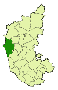
Ugarkhod is a village in Belgaum district in the southern state of Karnataka, India.

Barkov Glacier is a glacier draining northeast between Mount Dallmann and the central part of the Shcherbakov Range, in the Orvin Mountains, Queen Maud Land. First photographed and roughly plotted by the Third German Antarctic Expedition, 1938–39, it was mapped from air photos and surveys by the Sixth Norwegian Antarctic Expedition, 1956–60, remapped by the Soviet Antarctic Expedition, 1960–61, and named after Soviet geographer A.S. Barkov.

This is a list of the extreme points of Bhutan.
Erdőkürt is a village in Nógrád County, Hungary with 609 inhabitants (2001).
Kafr Shalaya is a Syrian village located in Ariha Nahiyah in Ariha District, Idlib. According to the Syria Central Bureau of Statistics (CBS), Kafr Shalaya had a population of 1459 in the 2004 census.
Baydar Shamsu is a Syrian village in Muhambal Nahiyah in Ariha District, Idlib. According to the Syria Central Bureau of Statistics (CBS), Baydar Shamsu had a population of 768 in the 2004 census.


