Algeria since December 18, 2019, is divided into 58 wilayas (provinces). Prior to December 18, 2019, there were 48 provinces. The 58 provinces are divided into 1541 baladiyahs. The capital city of a baladiyah, daïra, or province, always gives those entities their name, even Algiers, the capital of the country gave it its name.

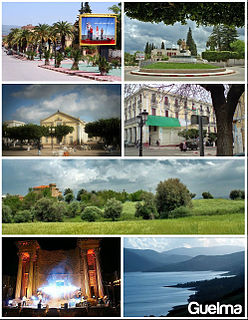
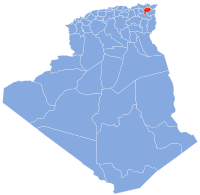
Guelma Province is a province (wilaya) in eastern Algeria. Its namesake is its seat and most populous municipality: Guelma.

Souk Ahras is a province (wilaya) in the Aures region in Algeria, named after its capital, Souk Ahras. It stands on the border between Algeria and Tunisia.

The Sétif and Guelma massacre was a series of attacks by French colonial authorities and pied-noir settler militias on Algerian civilians in 1945 around the market town of Sétif, west of Constantine, in French Algeria. French police fired on demonstrators at a protest on 8 May 1945. Riots in the town were followed by attacks on French settlers (colons) in the surrounding countryside, resulting in 102 deaths. Subsequent attacks by the French colonial authorities and European settlers killed between 6,000 and 30,000 Muslims in the region. Both the outbreak and the indiscriminate nature of its repression are thought to have marked a turning point in Franco-Algerian relations, leading to the Algerian War of 1954–1962.

Sétif is an Algerian city and the capital of the Sétif Province. It is one of the most important cities of eastern Algeria and the country as a whole, since it is considered the trade capital of the country. It is an inner city, situated in the eastern side of Algeria, at 270 kilometers east of Algiers, at 131 km west of Constantine, in the Hautes Plaines region south of Kabylie. The city is at 1,100 meters of altitude.

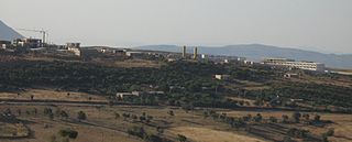
Guelma is the capital of Guelma Province and Guelma District, located in north-eastern Algeria, about 65 kilometers from the Mediterranean coast. Its location corresponds to that of ancient Calama.

El Taref is a province (wilaya) of Algeria. El Kala is a port town in this province. El Taref is the capital city. El Kala, a port town in this province, is home to El Kala National Park.

The provinces of Algeria are divided into 547 districts (daïras). The capital of a district is called a district seat. Each District is further divided into one or more municipalities (baladiyahs).

Guelaât Bou Sbaâ is a district in Guelma Province, Algeria. It ranks second in population after Guelma District. It was named after its capital, Guelaât Bou Sbaâ.

Khezaras is a district in Guelma Province, Algeria. It was named after its capital, Khezara.

Oued Zenati is a district in Guelma Province, Algeria. It was named after its capital, Oued Zenati, the second most populated municipality in the province.

Hammam Debagh is a district in Guelma Province, Algeria. It was named after its capital, the spa of Hammam Debagh.

Héliopolis is a district in Guelma Province, Algeria. It was named after its capital, Héliopolis.

Bouchegouf is a district in Guelma Province, Algeria. It was named after its capital, the spa of Hammam N'Bails.

Houari Boumédienne is a district in the Guelma Province of Algeria. It was named after former President of Algeria, Houari Boumédienne.

Aïn Makhlouf is a district in Guelma Province, Algeria. It was named after its capital, Aïn Makhlouf.

Ben Djerrah is a municipality in Guelma province, Algeria. It is located in Guelma district, to the southwest of the nearby city of Guelma. Its main settlement is the town of Ben Djerrah, even though the suburban sprawl of Guelma in the direction of Ben Djerrah is significant, seeing that it is the only other municipality in the district. It is the site of the forest of Aïn Séfra, as well as an important military garrison. It is connected by a Province Highway to southwestern Guelma, as well as by another shorter road connecting it to the inner suburbs of Guelma.

Aïn Touta is a town in eastern Algeria. It is located 35 km southwest of Batna and 82 km north of Biskra. It has an area of about five square kilometers.

Tamlouka is a small city of about 22.000 inhabitants in the District of Aïn Makhlouf of the Guelma Province in the northeast of Algeria. It is located at the intersection of W10 and W133, between the cities of Oued Zenati and Aïn Beïda. It is located 60 kilometres from Guelma, capital of the province. Prior to the mass renaming of towns after Algeria's independence, this town was known by the French name Montcalm. Most of the people in the city are Berber Chaouis, whose main dialect was one of Berber languages, but now most people know only Maghrebi Arabic.

Hammam Debagh is a town and commune in Guelma Province, Algeria. It is the district seat of Hammam Debagh District and the location of the famous Hammam Maskhoutine thermal complex.


