Bouchegouf District

Last updated
Boughouf
Commune and town
Bouchegouf bwshqwf.jpg
Dz - 24 - Bouchegouf district.svg
Map of Guelma Province highlighting the district
Algeria location map.svg
Red pog.svg
Boughouf
Location of district in Algeria map
Coordinates: 36°28′18″N7°43′47″E / 36.4717°N 7.7298°E / 36.4717; 7.7298
CountryFlag of Algeria.svg  Algeria
Province Guelma Province
Time zone UTC+1 (CET)

Bouchegouf is a town and district in Guelma Province, Algeria.

Contents

Town

The town of Bouchegouf, the ancient Niniba, is the third largest in the wilaya of Guelma in eastern Algeria, 35 km from its capital, 52 km from the wilaya of Annaba and 42 km from that of Souk Ahras. It is 600 km distant from the national capital, Algiers and 300 km from Tunisia. Under French colonial rule, it was called Duvivier. Of the 25,443 inhabitants of the district, 19,690 live in the town. [1]

Archaeology

The region of which Bouchegouf forms part contains some 40 archaeological sites of the prehistoric, protohistoric, Numidian, Roman and Byzantine periods.

The few protohistoric remains include the necropolis of Nador covering much of the eastern mountainside; the dolmens and Libyan steles at the end of Jebel Grine near Mechta de Fedj-Abdallah; the rock-cut vaults in the Sedjerma region; and a rock carving of a lion at Gafeza. Many pre-Roman tomb inscriptions in the Libyan language or in both Latin and Libyan have been published in the Recueil des Inscriptions Libyques, Nos. 446, 447, 448, 449. Stele 451 at Bouchegouf has with two parallel inscriptions, one in Libyan, the other in Punic. The Roman era is represented by the two Roman roads reported in the Tabula Peutingeriana : the imperial road from Hippo Regius by way of Vicus Iuliani to Tipaza (Tifeche) with ruins of a Roman bridge on the Seybouse; and that from Hippona (Annaba) to Thagaste (Tébessa) by way of Bouchegouf. [2] [ unreliable source? ]

Important Roman ruins at Medjez-Sfa, on the left bank of the wadi Melah include an inscription of a slave of an estate. Among the dozen Latin inscriptions found at Zattara near Kef bou Zioun is an important one attesting to its status as a municipium: municipii Zat(taresis) porticu et rostris [3] An extensive ancient cemetery at Koudiet el Batum has rock-cut tombs with human-shaped hollows, sarcophagi, and inscribed tombstones. At Debidib are Roman ruins of a large farmhouse with baths and cisterns. At the wayside station of wadi Frarah at Zaouiat el Guelaa, a round hill on the right bank of the Seybouse, which the river flows around, is topped by a rectangular fort of plain mortarless blocks. [2]

Geological overview

Bouchegouf region is mountainous, with average altitude of about 500 m, its appearance is the monotony of geological formations that constitute it. The territory represented 9/10e are formed by clay and sandstone numidien, they give the immense forest spread of Beni and Ouled Salah Bechia On the western edge, through the wadi Seybouse cluse in these formations numidiennes. The elevation of the bottom of its valley varies between 29 and 107m upstream from the confluence of Wadi Mellah. There are a series of alluvial terraces stage until about 150m. They are particularly between developed and Bouchegouf Boudaroua. In the south-west corner, within the angle formed by the Wadi Wadi and Seybouse Mellah is the northern extremity of the great dome of the Triassic-Jebel Nador Laverdure15. Forests blessed Salah is a good choice for the election of ground-oak and cork oak trees of ZENN dense, rich and varied that reflects an important geomorphological natural resources as essential for the ancient institution, the legal status of natural reserve area favors us for a good archaeological documentation (well-preserved samples). numidien The sandstone was also the testimony of ancient settlements among them remains unpublished. . The most famous of Nador is mine which was exploited by the Romans in shot lead, and zinc. Also hot springs and artesian had their significance have been well exploited cite as an example, al'extrême South East boucehgouf instead N'bail said Hammam, a spa, out today to 150 meters down form a new deposit of carbonate of lime. The upper source was captured by the Romans along the Roman road to a beautiful bathing establishment in ruins. The plain of Seybouse offers the most fertile land of good quality crops are much more varied and rich in cereals, tobacco, vine, vegetable, fruit trees, olive trees. What is the testimony of farms, oil, firm of ancient times. [2]

Research history

Archaeological research on the region Bouchegouf are old. These are notes that studies dating back to the nineteenth century and from the officers of the French army who had the opportunity to explore the territory in collaboration with Algerian civilians from the administrative area and school. They should at Charles de Vigneral, Levistre Chassaigne and summarize the results of excavations at Dolmen di Nador and Wadi Frarah. Reboud et Mercier, published several notes on the region. Mougel. was the recipient of the Academy of Hippo, who lived fifteen years has Duvivier (Bouchegouf) until 1894. As administrative officer to the curia, he conducted several surveys in the region, publishing in the Bulletin of the Academy of Hippo. St. Gsell published a large number of inscriptions from the region of Bouchegouf and its surroundings. [2]

Geomorphological data analysis, the territory was Bouchegouf strategic roads and ancient human settlements. Its strategic geographical position for transport, is in the form of a node where the ancient main roads (Thagaste Hippo, Hippo Tifeche) met. The confluence of two rivers (el Mellah and Seybouse) provided a water resource and the possibility of transporting goods. The territory is rich in archaeological evidence of its witnesses agricultural productivity (olive oil, cereals).

Archaeological research conducted so far, now dated and incomplete, have been in a logical menu colonialist and selective. Archaeological records were made on the basis of signs and sporadic discoveries. The surveys were ad hoc and based on the criteria of monumentality with a predilection philological epigraphic material. [2] Indeed, the wealth of the territory in terms of ancient epigraphic heritage, discovered in the area remains unexplored and has not been reading organic and territorial. A multidisciplinary review of the entries in a territorial logic related to archaeological traces still exist, would better understand the social and legal status of the area especially with the presence of local names and pre-Roman (nota) which suggests an interaction between fervent local culture and Roman culture.

The intention is to retain the material published so far and compare with a systematic exploration of the territory that would bring to the detailed documentation of archaeological sites, the communication network with data geomorphological, pedological, and geological. All of its investigation would include the distribution of human settlement in the region by analyzing the use and occupancy of land and socio-economic systems generated. [2]

Municipalities

The district is divided into 4 municipalities: [4]

Related Research Articles

<span class="mw-page-title-main">Hippo Regius</span> Ancient name for the modern city of Annaba, Algeria

Hippo Regius is the ancient name of the modern city of Annaba, Algeria. It historically served as an important city for the Phoenicians, Berbers, Romans, and Vandals. Hippo was the capital city of the Vandal Kingdom from 435 to 439 AD. until it was shifted to Carthage following the Vandal capture of Carthage (439).

<span class="mw-page-title-main">North Africa during classical antiquity</span> Historic phases of North Africa (c. 8th cent. BCE - 5th cent.CE)

The history of North Africa during the period of classical antiquity can be divided roughly into the history of Egypt in the east, the history of ancient Libya in the middle and the history of Numidia and Mauretania in the West.

<span class="mw-page-title-main">Annaba</span> City in Annaba Province, Algeria

Annaba, formerly known as Bon, Bona and Bône, is a seaport city in the northeastern corner of Algeria, close to the border with Tunisia. Annaba is near the small Seybouse River and is in the Annaba Province. With a population of about 464,740 (2019) and 1,000,000 for the metropolitan area, Annaba is the third-largest city and the leading industrial center in Algeria.

<span class="mw-page-title-main">Guelma Province</span> Province of Algeria

Guelma Province is a province (wilaya) in eastern Algeria. Its namesake is its seat and most populous municipality: Guelma.

<span class="mw-page-title-main">Souk Ahras Province</span> Province of Algeria

Souk Ahras is a province (wilaya) in the Aures region in Algeria, named after its capital, Souk Ahras. It stands on the border between Algeria and Tunisia. In 2008, Souk Ahras had a population of 440,299 people.

<span class="mw-page-title-main">Guelma</span> City in Algeria

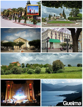
Guelma is the capital of Guelma Province and Guelma District, located in north-eastern Algeria, about 65 kilometers from the Mediterranean coast. Its location corresponds to that of ancient Calama.

<span class="mw-page-title-main">Thubursicum</span>

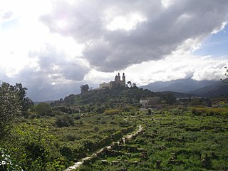
Khamissa, ancient Thubursicum Numidarum or Thubursicum, is an Ancient Roman and Byzantine archeological site, in Souk Ahras Province of northeastern Algeria.

<span class="mw-page-title-main">Thagaste</span>

Thagaste was a Roman-Berber city in present-day Algeria, now called Souk Ahras. The town was the birthplace of Saint Augustine.

<span class="mw-page-title-main">Chetaïbi</span> City in Annaba, Algeria

Chetaïbi is a small fishing port in Annaba Province, Algeria located on a peninsula west of Annaba.

<span class="mw-page-title-main">Souk Ahras</span> City and commune in Algeria

Souk Ahras is a municipality in Algeria. It is the capital of Souk Ahras Province. The Numidian city of Thagaste, on whose ruins Souk Ahras was built, was the birthplace of Augustine of Hippo and a center of Berber culture.

<span class="mw-page-title-main">Ouenza</span> City and Commune in Tébessa Province, Algeria

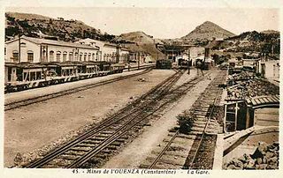
Ouenza is a town in Tébessa Province, in far eastern Algeria; near the border with Tunisia; 43 km south of Souk Ahras; and west of M'Daourouch.

<span class="mw-page-title-main">Guelma District</span> District in Guelma, Algeria

Guelma District is an Algerian district in Guelma Province, in northeastern Algeria.

<span class="mw-page-title-main">El Amra</span> Place in Aïn Defla, Algeria

El Amra is a town in northern Algeria.

<span class="mw-page-title-main">Damous</span> Commune and town in Tipaza Province, Algeria

Damous is a town and commune in Tipaza Province in northern Algeria.

The Maghreb highway is a highway through the Maghreb region of North Africa. The highway is made up of an Atlantic main road, and a Mediterranean main road.

Mertoutek is a village in the commune of Idlès, in Tazrouk District, Tamanrasset Province, Algeria. It lies in the northern Hoggar Mountains on the eastern side of a wadi, 61 kilometres (38 mi) northwest of the town of Idlès and 158 kilometres (98 mi) north of Tamanrasset.

<span class="mw-page-title-main">Calama (Numidia)</span>

Calama was a colonia in the Roman province of Numidia situated where Guelma in Algeria now stands.

<span class="mw-page-title-main">Numidia (Roman province)</span> Roman province

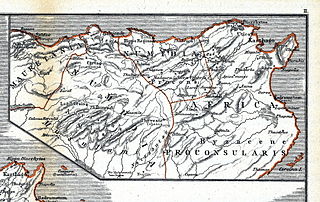
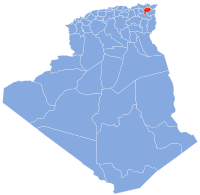
Numidia was a Roman province on the North African coast, comprising roughly the territory of north-east Algeria.

Tipasa, distinguished as Tipasa in Numidia, was a town in the Roman province of Numidia in North Africa. Its ruins are located 957 meters (3,140 ft) above sea level near present-day Tifesh in Constantine Province, Algeria, 88 kilometers (55 mi) south of Annaba.

Nacéra Benseddik is an Algerian historian, archaeologist and epigrapher. She was born in Bordj Bou Arreridj on 4 December 1949.

References

  1. Répartition de la population résidente des ménages ordinaires et collectifs, selon la commune de résidence et la dispersion Archived May 16, 2013, at the Wayback Machine
  2. 1 2 3 4 5 6 Unpublished doctoral thesis of Samir Houamria
  3. CIL 08,05178- ILAlg-01,00553[ full citation needed ]
  4. "Décret executif n° 91-306 du 24 août 1991 fixant la liste des communes animées par chaque chef de daïra. 26 - Wilaya de Médéa" (PDF). Journal officiel de la République algérienne démocratique et populaire. 4 September 1991. p. 1307. Retrieved 5 January 2020.