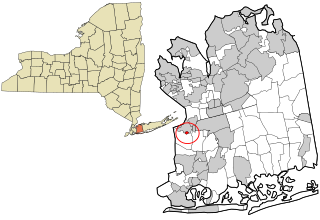
South Floral Park is a village in Nassau County, New York, United States. United States. The population was 1,764 at the 2010 census.

Ivatsevichy (Ivacevičy) District is an administrative subdivision, a raion of Brest Region, in Belarus.

The Olympic Pool, formerly Swimming Pool of the Central Lenin Stadium is an aquatics center that is part of the Luzhniki Sports Complex in Moscow, Russia. It was opened in 1957 and renovated in 1980. The 10,500-seat venue hosted water polo events at the 1980 Summer Olympics. It also hosted events of the 1973 Summer Universiade, 12th World Festival of Youth and Students, 1986 Goodwill Games, Spartakiads of the Peoples of the USSR and others.

Stillwell is an unincorporated community in Pleasant Township, LaPorte County, Indiana.
Chincheros is the Capital of the Province Chincheros. Chincheros District is one of the eight districts of the province Chincheros in Peru.
Kęsowo is a village in Tuchola County, Kuyavian-Pomeranian Voivodeship, in north-central Poland. It is the seat of the gmina called Gmina Kęsowo. It lies approximately 11 kilometres (7 mi) south-west of Tuchola and 53 km (33 mi) north of Bydgoszcz.
Dąbrowa is a village in the administrative district of Gmina Narewka, within Hajnówka County, Podlaskie Voivodeship, in north-eastern Poland, close to the border with Belarus.

Kərimli is a village in the Gadabay Rayon of Azerbaijan.
Çay Tumas is a village in the Qubadli Rayon of Azerbaijan.
Dəmirçilər is a village in the Khojali Rayon of Azerbaijan.

Krzelów is a village in the administrative district of Gmina Sędziszów, within Jędrzejów County, Świętokrzyskie Voivodeship, in south-central Poland. It lies approximately 7 kilometres (4 mi) south-west of Sędziszów, 24 km (15 mi) west of Jędrzejów, and 58 km (36 mi) south-west of the regional capital Kielce.
Przytuły Stare is a village in the administrative district of Gmina Rzekuń, within Ostrołęka County, Masovian Voivodeship, in east-central Poland. It lies approximately 8 kilometres (5 mi) north-east of Rzekuń, 11 km (7 mi) east of Ostrołęka, and 110 km (68 mi) north-east of Warsaw.
Starcz is a village in the administrative district of Gmina Lutocin, within Żuromin County, Masovian Voivodeship, in east-central Poland. It lies approximately 14 kilometres (9 mi) west of Żuromin and 126 km (78 mi) north-west of Warsaw.
Baraniec is a settlement in the administrative district of Gmina Pyzdry, within Września County, Greater Poland Voivodeship, in west-central Poland.
Święciechów is a village in the administrative district of Gmina Drawno, within Choszczno County, West Pomeranian Voivodeship, in northwest Poland. It lies approximately 5 kilometres (3 mi) north-west of Drawno, 24 km (15 mi) north-east of Choszczno, and 78 km (48 mi) east of the regional capital Szczecin.
Kępiny is a village in the administrative district of Gmina Polanów, within Koszalin County, West Pomeranian Voivodeship, in north-western Poland. It lies approximately 10 kilometres (6 mi) south of Polanów, 40 km (25 mi) south-east of Koszalin, and 156 km (97 mi) north-east of the regional capital Szczecin.

Xiaodian District is a district of Taiyuan, the capital of Shanxi province, China.
Meelva is a village in Lääneranna Parish, Pärnu County, in western Estonia.
Tachouda is a town and commune in Sétif Province in north-eastern Algeria.
Stadionul Viitorul is a multi-purpose stadium in Ovidiu, Romania. It is currently used mostly for football matches and is the home ground of Viitorul Constanța. The stadium holds 4,554 people.


