
Palembang is the capital city of the Indonesian province of South Sumatra. The city proper covers 352.51 square kilometres on both banks of the Musi River in the eastern lowlands of southern Sumatra. It had a population of 1,668,848 at the 2020 Census; the official estimate as at mid 2023 was 1,772,492. Palembang is the second most populous city in Sumatra, after Medan, and the twelfth most populous city in Indonesia.

South Sumatra is a province of Indonesia, located in the southeast of the island of Sumatra. The capital and largest city of the province is the city of Palembang. The province borders the provinces of Jambi to the north, Bengkulu to the west and Lampung to the south, as well a maritime border with the Bangka Belitung Islands to the east. It is the largest province in the island of Sumatra, and it is slightly smaller than Portugal, the department of Boquerón in Paraguay or the U.S. state of Maine. The Bangka Strait in the east separates South Sumatra and the island of Bangka, which is part of the Bangka Belitung Islands province. The province has an area of 91,592.43 km2 (35,364 sq mi) and had a population of 8,467,432 at the 2020 Census; the official estimate as at mid-2023 was 8,743,522. The province is rich in natural resources, such as petroleum, natural gas and coal. The province is inhabited by many different malay sub ethnic groups, with Palembangese being largest ethnic group. Most speak the Palembang language, which is mutually intelligible to both Indonesian and local Palembang Malay. Other ethnic groups include the Javanese, Sundanese, Minangkabau and Chinese. Most are concentrated in urban areas and are largely immigrants from other parts of Indonesia.

Lampung, officially the Province of Lampung, is a province of Indonesia. It is located on the southern tip of the island of Sumatra. It has a short border with the province of Bengkulu to the northwest, and a longer border with the province of South Sumatra to the north, as well a maritime border with the province of Banten and Jakarta to the east. It is the original home of the Lampung people, who speak their own language, and possess their own written script. Its capital is Bandar Lampung.

Bandar Lampung is the capital and largest city of the Indonesian province of Lampung. Located on the southern tip of Sumatra, Bandar Lampung was originally called Tanjungkarang–Telukbetung, since it was a unification of two major settlements in Lampung, before being renamed in 1983.

The Trans-Sumatra Highway is a primary north–south road in the Indonesian island of Sumatra, 2,508.5 km in length, and connecting the northern island at Banda Aceh to Bandar Lampung in the south, running through many major cities, traversing Medan, Pekanbaru, Jambi, and Palembang along the way. Upgrade work is expected to begin in March 2013 transforming it into a full-fledged highway, including land acquisition.
In Indonesia, village or subdistrict is the fourth-level subdivision and the smallest administrative division of Indonesia below a district, regency/city, and province. Similar administrative divisions outside of Indonesia include barangays in the Philippines, Muban in Thailand, civil townships and incorporated municipalities in the United States and Canada, communes in France and Vietnam, dehestan in Iran, hromada in Ukraine, Gemeinden in Germany, comuni in Italy, or municipios in Spain. The UK equivalent are civil parishes in England and communities in Wales. There are a number of names and types for villages in Indonesia, with desa being the most frequently used for regencies, and kelurahan for cities or for those communities within regencies which have town characteristics. According to the 2019 report by the Ministry of Home Affairs, there are 8,488 urban villages and 74,953 rural villages in Indonesia. North Aceh Regency contained the highest number of rural villages (852) amongst all of the regencies of Indonesia, followed by Pidie Regency with 730 rural villages and Bireuen Regency with 609 rural villages. Prabumulih, with only 12 rural villages, contained the fewest. Counted together, the sixteen regencies of Indonesia containing the most rural villages—namely, North Aceh (852), Pidie (730), Bireuen (609), Aceh Besar (604), Tolikara (541), East Aceh (513), Yahukimo (510), Purworejo (469), Lamongan (462), South Nias (459), Kebumen (449), Garut (421), Bojonegoro (419), Bogor (416), Cirebon (412), and Pati (401)—contain one-third of all the rural villages in Indonesia. Five of these are located in Aceh, two in Highland Papua, three in Central Java, two in East Java, three in West Java, and one in North Sumatra. An average number of rural villages in the regencies and 15 cities of Indonesia is 172 villages. A village is the lowest administrative division in Indonesia, and it is the lowest of the four levels. The average land area of villages in Indonesia is about 25.41 km2 (9.81 sq mi), while its average population is about 3,723 people.
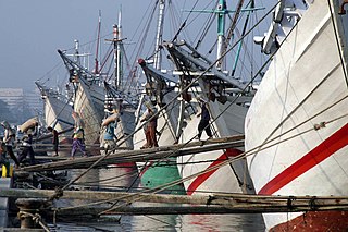
Sunda Kelapa is the old port of Jakarta, located on the estuary of the Ciliwung River. "Sunda Kalapa" is the original name, and it was the main port of the Sunda Kingdom. The port is situated in Penjaringan District, of North Jakarta, Indonesia. Today the old port only accommodates pinisi, a traditional two-masted wooden sailing ship providing inter-island freight service in the archipelago. Although it is now only a minor port, Jakarta has its origins in Sunda Kelapa and it played a significant role in the city's development. The port is currently operated by the state-owned Indonesia Port Corporations.

Military Region Command II/Sriwijaya is an Indonesian Army Regional Military Command that covers the provinces of Bengkulu, Jambi, South Sumatra, Bangka-Belitung Islands and Lampung.
North Lampung Regency is an inland regency (kabupaten) of Lampung Province, Sumatra, in Indonesia. As originally created, it covered a much larger share of the land area of Lampung Province, but on 16 August 1991 its western districts were split off to create a new West Lampung Regency ; on 3 January 1997 its north-eastern districts were split off to create a new Tulang Bawang Regency ; and on 20 April 1999 its north-western districts were split off to create a new Way Kanan Regency.

Tulang Bawang Regency is a regency (kabupaten) of Lampung Province, Sumatra, Indonesia. The regency was created on 3 January 1997 from the eastern half of North Lampung Regency; when created, it originally covered a much wider area, but on 29 October 2008 the seven northern districts were separated off to form a new Mesuji Regency, and the eight western districts were also separated off to form a new West Tulang Bawang Regency. It now has an area of 3,466.32 square kilometres (1,338.35 sq mi) and had a population of 397,906 at the 2010 Census and 430,021 at the 2020 Census; the official estimate as at mid 2023 was 433,570. The regency seat is the town of Menggala, located about 120 kilometres (75 mi) from the provincial capital of Bandar Lampung. The regency takes its name from the Tulang Bawang River which flows through the province.

West Tulang Bawang Regency is a regency (kabupaten) of Lampung Province, Sumatra, Indonesia. It was created on 29 October 2008 from what were formerly the western districts of Tulang Bawang Regency. It has an area of 1,201.15 km2 and had a population of 250,707 people at the 2010 Census and 286,162 at the 2020 Census; the official estimate as at mid 2023 was 295,481. The regency seat is the town of Panaragan Jaya.

The Lampung or Lampungese are an indigenous ethnic group native to Lampung and some parts of South Sumatra, Bengkulu, as well as in the southwest coast of Banten. They speak the Lampung language, a Lampungic language estimated to have 1.5 million speakers.

The Tulang Bawang River is a river which mostly flows in Lampung, Indonesia. The river lends its name to the Tulang Bawang Regency, where it reaches the Java Sea and the West Tulang Bawang Regency. It also flows across the capital of the regency at Menggala.
Mahmud Badaruddin I, also known as Jayo Wikramo, was the fourth regent of the Palembang Sultanate in Palembang, South Sumatra. Mahmud Badaruddin I reigned the Palembang Sultanate between 1724 and 1757.
This is a list of emblems or coat of arms used in Indonesia. Indonesia is divided into 38 provinces, and each province is divided into regencies (kabupaten) and cities (kota). There are 416 regencies and 98 cities. Each province, regency, and city has its own emblem.
Banjar Agung is a district (kecamatan) located in the Tulang Bawang Regency of Lampung Province in Sumatra, Indonesia.
Banjar Baru is a district (kecamatan) located in the Tulang Bawang Regency of Lampung Province in Sumatra, Indonesia.
East Menggala is a district located in the Tulang Bawang Regency of Lampung in Sumatra, Indonesia.


